Property Record
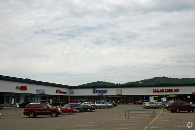
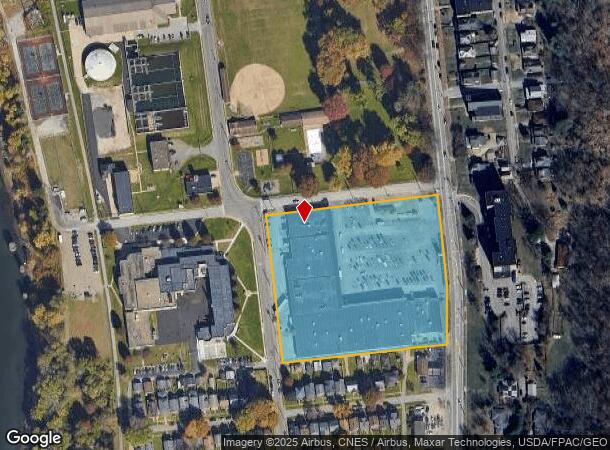
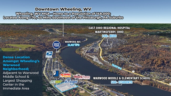
Warwood Ave, Wheeling, WV 26003
NEARBY LISTINGS FOR SALE OR LEASE
Property Detail
Warwood Ave
10-W10-01250000
20 91 0000-00 W10 0125
Communitycenter
5.2415 A OHIO RIVER ROAD
X
Ohio
54051C0025E
West Virginia
2025
5.24 AC
2025
West Virginia North Area
001400
Other Market Areas
55,622 SF
Wheeling, WV-OH
DEMOGRAPHICS near Warwood Ave
1 Mile
3 Mile
5 Mile
2024 Total Population
3,881
19,942
41,880
2029 Population
3,747
19,400
40,906
Pop Growth 2024-2029
(3.45%)
(2.72%)
(2.33%)
Average Age
42
42
43
2024 Total Households
1,684
8,681
18,665
HH Growth 2024-2029
(3.44%)
(2.71%)
(2.33%)
Median Household Inc
$45,793
$48,138
$46,298
Avg Household Size
2.20
2.20
2.10
2024 Avg HH Vehicles
1.00
2.00
2.00
Median Home Value
$83,008
$116,089
$121,501
Median Year Built
1947
1951
1951
Nearby Places
Map Layers
Map Styles
 Street
 Aerial
- Restaurants
- Banks
- Shops
- Fitness
- Groceries
SALE & LEASE HISTORY
LISTING DATE
SALE/LEASE

Sep 21, 2021
For Lease
Mar 01, 2017
For Lease
Apr 01, 2025
For Sale
Nearby Properties
Address
Land Use
TOTAL SIZE
Lot Size
Zoning
Address
Land Use
TOTAL SIZE
Lot Size
Zoning
1,067.71 AC
Address
Land Use
TOTAL SIZE
Lot Size
Zoning
215,102 SF
33.88 AC
Address
Land Use
TOTAL SIZE
Lot Size
Zoning
56.53 AC
Address
Land Use
TOTAL SIZE
Lot Size
Zoning
276,512 SF
5.92 AC
Address
Land Use
TOTAL SIZE
Lot Size
Zoning
167,190 SF
40 AC
Address
Land Use
TOTAL SIZE
Lot Size
Zoning
5.37 AC
Address
Land Use
TOTAL SIZE
Lot Size
Zoning
24,111 SF
0.12 AC
Address
Land Use
TOTAL SIZE
Lot Size
Zoning
Address
Land Use
TOTAL SIZE
Lot Size
Zoning
1.57 AC
Address
Land Use
TOTAL SIZE
Lot Size
Zoning
1.42 AC
Address
Land Use
TOTAL SIZE
Lot Size
Zoning
21.01 AC
Address
Land Use
TOTAL SIZE
Lot Size
Zoning
0.28 AC
Address
Land Use
TOTAL SIZE
Lot Size
Zoning
1,628 SF
35 AC
Address
Land Use
TOTAL SIZE
Lot Size
Zoning
4.84 AC
Address
Land Use
TOTAL SIZE
Lot Size
Zoning
2.26 AC
Address
Land Use
TOTAL SIZE
Lot Size
Zoning
221.23 AC
Address
Land Use
TOTAL SIZE
Lot Size
Zoning
1.25 AC
Address
Land Use
TOTAL SIZE
Lot Size
Zoning
87,334 SF
1.69 AC
Address
Land Use
TOTAL SIZE
Lot Size
Zoning
1.99 AC
Address
Land Use
TOTAL SIZE
Lot Size
Zoning
64.51 AC
Address
Land Use
TOTAL SIZE
Lot Size
Zoning
Address
Land Use
TOTAL SIZE
Lot Size
Zoning
Address
Land Use
TOTAL SIZE
Lot Size
Zoning
2.67 AC
Address
Land Use
TOTAL SIZE
Lot Size
Zoning
91,628 SF
4.57 AC
Address
Land Use
TOTAL SIZE
Lot Size
Zoning
5.09 AC
Address
Land Use
TOTAL SIZE
Lot Size
Zoning
101,250 SF
6.17 AC
Address
Land Use
TOTAL SIZE
Lot Size
Zoning
0.43 AC
Address
Land Use
TOTAL SIZE
Lot Size
Zoning
42.04 AC
Address
Land Use
TOTAL SIZE
Lot Size
Zoning
40.01 AC
The World's #1 Commercial Real Estate Marketplace
Connect with us
© 2026 CoStar Group
The information above has been obtained from sources believed reliable. While we do not doubt its accuracy we have not verified it and make no guarantee, warranty or representation about it. It is your responsibility to independently confirm its accuracy and completeness. Any projections, opinions, assumptions, or estimates used are for example only and do not represent the current or future performance of the property. The value of this transaction to you depends on tax and other factors which should be evaluated by your tax, financial, and legal advisors. You and your advisors should conduct a careful, independent investigation of the property to determine to your satisfaction the suitability of the property for your needs.