Property Record
1200 Avondale Haslet Rd, Haslet, TX 76052
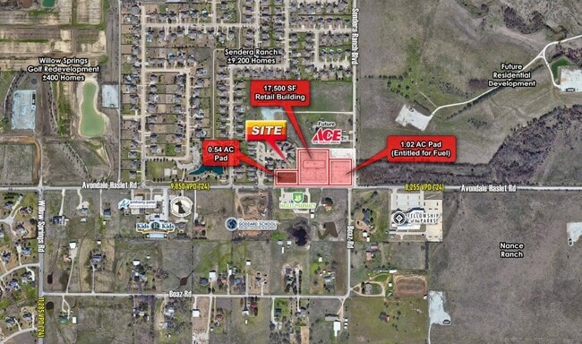

This Property Is For Sale
NEARBY LISTINGS FOR SALE OR LEASE
Property Detail
1200 Avondale Haslet Rd
Dallas-Fort Worth-Arlington, TX
Boyd, Coleman Survey
40529460
BOYD, COLEMAN SURVEY ABSTRACT 212 TRACT 3F ROW
Residentialacreage
Tarrant
X
Texas
48439C0035L
0.33 AC
2023
Alliance
2025
Dallas/Ft Worth
114112
DEMOGRAPHICS near 1200 Avondale Haslet Rd
1 Mile
3 Mile
5 Mile
2024 Total Population
4,146
31,813
67,198
2029 Population
4,521
35,286
73,921
Pop Growth 2024-2029
+ 9.04%
+ 10.92%
+ 10.00%
Average Age
35
35
35
2024 Total Households
1,192
9,840
21,231
HH Growth 2024-2029
+ 9.31%
+ 11.14%
+ 10.13%
Median Household Inc
$170,730
$151,329
$136,452
Avg Household Size
3.30
3.20
3.10
2024 Avg HH Vehicles
3.00
2.00
2.00
Median Home Value
$681,485
$463,032
$413,947
Median Year Built
2008
2010
2010
Nearby Places
Map Layers
Map Styles
 Street
 Aerial
- Restaurants
- Banks
- Shops
- Fitness
- Groceries
PUBLIC TRANSPORTATION
AIRPORT
Dallas-Fort Worth International
DRIVE
WALK
Distance
Dallas-Fort Worth International
35 min
26.0 mi
Freight Ports
Port of Shreveport
DRIVE
WALK
Distance
Port of Shreveport
263 min
239.5 mi
Nearby Properties
Address
Land Use
TOTAL SIZE
Lot Size
Zoning
Address
Land Use
TOTAL SIZE
Lot Size
Zoning
348,270 SF
39.34 AC
Address
Land Use
TOTAL SIZE
Lot Size
Zoning
830,399 SF
11.02 AC
Address
Land Use
TOTAL SIZE
Lot Size
Zoning
553,605 SF
81.10 AC
Address
Land Use
TOTAL SIZE
Lot Size
Zoning
305,697 SF
42.24 AC
Address
Land Use
TOTAL SIZE
Lot Size
Zoning
1,141,133 SF
67.79 AC
Address
Land Use
TOTAL SIZE
Lot Size
Zoning
422,682 SF
22.66 AC
Address
Land Use
TOTAL SIZE
Lot Size
Zoning
504,000 SF
26.39 AC
Address
Land Use
TOTAL SIZE
Lot Size
Zoning
882,565 SF
56.65 AC
Address
Land Use
TOTAL SIZE
Lot Size
Zoning
807,229 SF
46.10 AC
Address
Land Use
TOTAL SIZE
Lot Size
Zoning
562,500 SF
29.64 AC
Address
Land Use
TOTAL SIZE
Lot Size
Zoning
184,400 SF
19.75 AC
Address
Land Use
TOTAL SIZE
Lot Size
Zoning
436,589 SF
32.43 AC
Address
Land Use
TOTAL SIZE
Lot Size
Zoning
74,825 SF
13.41 AC
Address
Land Use
TOTAL SIZE
Lot Size
Zoning
436,589 SF
32.33 AC
Address
Land Use
TOTAL SIZE
Lot Size
Zoning
46,464 SF
15.24 AC
Address
Land Use
TOTAL SIZE
Lot Size
Zoning
288,191 SF
16.57 AC
Address
Land Use
TOTAL SIZE
Lot Size
Zoning
247,070 SF
5.79 AC
Address
Land Use
TOTAL SIZE
Lot Size
Zoning
72,713 SF
10.88 AC
Address
Land Use
TOTAL SIZE
Lot Size
Zoning
181,074 SF
14 AC
Address
Land Use
TOTAL SIZE
Lot Size
Zoning
54,510 SF
5 AC
Address
Land Use
TOTAL SIZE
Lot Size
Zoning
53,619 SF
14.34 AC
Address
Land Use
TOTAL SIZE
Lot Size
Zoning
147,806 SF
21.60 AC
Address
Land Use
TOTAL SIZE
Lot Size
Zoning
212,388 SF
28.94 AC
Address
Land Use
TOTAL SIZE
Lot Size
Zoning
115,723 SF
21.64 AC
Address
Land Use
TOTAL SIZE
Lot Size
Zoning
55,000 SF
13.80 AC
Address
Land Use
TOTAL SIZE
Lot Size
Zoning
111,532 SF
6.75 AC
Address
Land Use
TOTAL SIZE
Lot Size
Zoning
8,707 SF
6.23 AC
Address
Land Use
TOTAL SIZE
Lot Size
Zoning
53,064 SF
27.41 AC
Address
Land Use
TOTAL SIZE
Lot Size
Zoning
30,788 SF
3.29 AC
Address
Land Use
TOTAL SIZE
Lot Size
Zoning
43,231 SF
25.44 AC
The World's #1 Commercial Real Estate Marketplace
Connect with us
© 2025 CoStar Group
The information above has been obtained from sources believed reliable. While we do not doubt its accuracy we have not verified it and make no guarantee, warranty or representation about it. It is your responsibility to independently confirm its accuracy and completeness. Any projections, opinions, assumptions, or estimates used are for example only and do not represent the current or future performance of the property. The value of this transaction to you depends on tax and other factors which should be evaluated by your tax, financial, and legal advisors. You and your advisors should conduct a careful, independent investigation of the property to determine to your satisfaction the suitability of the property for your needs.