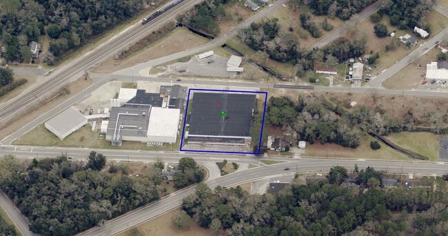
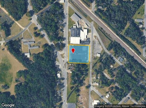
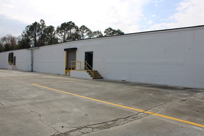
Property Record
1200 Brunel St, Waycross, GA 31501
NEARBY LISTINGS FOR SALE OR LEASE
-
-
View all Waycross listings for lease on LoopNet.com
Property Detail
1200 Brunel St
WA1205-064-A
Zachary
Warehouse
BRUNEL ST 1200 BC L9-13,18-22
AE
Ware
13229C0280D
Georgia
2025
1.66 AC
2025
Georgia South Area
950900
Other Market Areas
45,576 SF
Waycross, GA
DEMOGRAPHICS near 1200 Brunel St
1 Mile
3 Mile
5 Mile
2024 Total Population
4,298
20,986
28,962
2029 Population
4,404
21,001
28,943
Pop Growth 2024-2029
+ 2.47%
+ 0.07%
(0.07%)
Average Age
37
40
40
2024 Total Households
1,645
8,424
11,435
HH Growth 2024-2029
+ 2.31%
(0.17%)
(0.26%)
Median Household Inc
$32,758
$34,983
$38,364
Avg Household Size
2.50
2.40
2.40
2024 Avg HH Vehicles
1.00
1.00
2.00
Median Home Value
$59,660
$77,200
$92,701
Median Year Built
1967
1971
1976
Nearby Places
Map Layers
Map Styles
 Street
 Aerial
- Restaurants
- Banks
- Shops
- Fitness
- Groceries
SALE & LEASE HISTORY
LISTING DATE
SALE/LEASE

Dec 17, 2021
For Lease
Nearby Properties
Address
Land Use
TOTAL SIZE
Lot Size
Zoning
Address
Land Use
TOTAL SIZE
Lot Size
Zoning
3,880 SF
141.42 AC
005
Address
Land Use
TOTAL SIZE
Lot Size
Zoning
71.65 AC
006
Address
Land Use
TOTAL SIZE
Lot Size
Zoning
21,671 SF
116.27 AC
005
Address
Land Use
TOTAL SIZE
Lot Size
Zoning
64,745 SF
13.49 AC
001
Address
Land Use
TOTAL SIZE
Lot Size
Zoning
5,474 SF
5.18 AC
005
Address
Land Use
TOTAL SIZE
Lot Size
Zoning
120,700 SF
22.70 AC
001
Address
Land Use
TOTAL SIZE
Lot Size
Zoning
260,001 SF
14.28 AC
009
Address
Land Use
TOTAL SIZE
Lot Size
Zoning
205,040 SF
19.22 AC
002
Address
Land Use
TOTAL SIZE
Lot Size
Zoning
52,943 SF
155.98 AC
006
Address
Land Use
TOTAL SIZE
Lot Size
Zoning
3,250 SF
7.25 AC
005
Address
Land Use
TOTAL SIZE
Lot Size
Zoning
74,500 SF
24.83 AC
006
Address
Land Use
TOTAL SIZE
Lot Size
Zoning
145,392 SF
26.93 AC
002
Address
Land Use
TOTAL SIZE
Lot Size
Zoning
74,232 SF
13.77 AC
005
Address
Land Use
TOTAL SIZE
Lot Size
Zoning
36,654 SF
7.50 AC
005
Address
Land Use
TOTAL SIZE
Lot Size
Zoning
61,026 SF
8 AC
006
Address
Land Use
TOTAL SIZE
Lot Size
Zoning
286,172 SF
31.62 AC
002
Address
Land Use
TOTAL SIZE
Lot Size
Zoning
86,525 SF
10.46 AC
002
Address
Land Use
TOTAL SIZE
Lot Size
Zoning
34,125 SF
2.67 AC
005
Address
Land Use
TOTAL SIZE
Lot Size
Zoning
37,800 SF
3.93 AC
005
Address
Land Use
TOTAL SIZE
Lot Size
Zoning
34,492 SF
0.69 AC
005
Address
Land Use
TOTAL SIZE
Lot Size
Zoning
50,253 SF
7.13 AC
002
Address
Land Use
TOTAL SIZE
Lot Size
Zoning
23,854 SF
14.62 AC
005
Address
Land Use
TOTAL SIZE
Lot Size
Zoning
12,417 SF
10.69 AC
001
Address
Land Use
TOTAL SIZE
Lot Size
Zoning
40,016 SF
15.54 AC
006
Address
Land Use
TOTAL SIZE
Lot Size
Zoning
59,671 SF
7.75 AC
002
Address
Land Use
TOTAL SIZE
Lot Size
Zoning
55,024 SF
1.55 AC
002
Address
Land Use
TOTAL SIZE
Lot Size
Zoning
51,918 SF
7.84 AC
002
Address
Land Use
TOTAL SIZE
Lot Size
Zoning
21,805 SF
2.87 AC
006
Address
Land Use
TOTAL SIZE
Lot Size
Zoning
37,532 SF
1.39 AC
002
Address
Land Use
TOTAL SIZE
Lot Size
Zoning
44,800 SF
7.97 AC
002
The World's #1 Commercial Real Estate Marketplace
Connect with us
© 2026 CoStar Group
The information above has been obtained from sources believed reliable. While we do not doubt its accuracy we have not verified it and make no guarantee, warranty or representation about it. It is your responsibility to independently confirm its accuracy and completeness. Any projections, opinions, assumptions, or estimates used are for example only and do not represent the current or future performance of the property. The value of this transaction to you depends on tax and other factors which should be evaluated by your tax, financial, and legal advisors. You and your advisors should conduct a careful, independent investigation of the property to determine to your satisfaction the suitability of the property for your needs.