Property Record
1040 E 3Rd St, Siler City, NC 27344
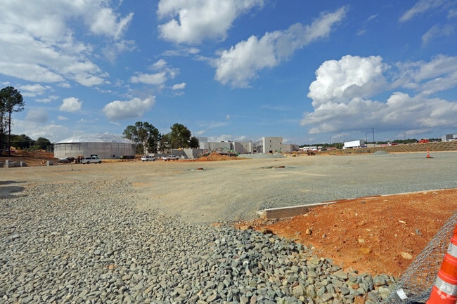

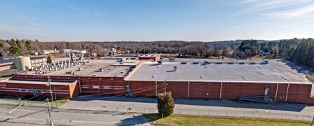
Property Detail
1040 E 3Rd St
16852
SC-118-10-6 AC 24.475 BK 2022 PG 8
Realpropertynec
Chatham
H-I
North Carolina
B and X Area of moderate flood hazard, usually the area between the limits of the 100-year and 500-year floods.
24.48 AC
2025
Chatham County
2025
Raleigh/Durham
020402
Durham-Chapel Hill, NC
10,280 SF
NEARBY LISTINGS FOR SALE OR LEASE
DEMOGRAPHICS near 1040 E 3Rd St
1 mile
3 mile
5 mile
2025 Total Population
4,341
11,860
14,764
2030 Population
4,667
12,792
15,969
Pop Growth 2025-2030
+ 7.51%
+ 7.86%
+ 8.16%
Average Age
38
39
40
2025 Total Households
1,610
4,278
5,473
HH Growth 2025-2030
+ 7.83%
+ 8.13%
+ 8.46%
Median Household Inc
$49,014
$57,551
$58,987
Avg Household Size
2.70
2.70
2.60
2025 Avg HH Vehicles
2.00
2.00
2.00
Median Home Value
$165,636
$185,219
$212,522
Median Year Built
1974
1981
1984
Nearby Places
Map Layers
Map Styles
 Street
 Aerial
Transit
 Traffic
 Biking
Places
Listings with unknown addresses are not visible on the map
- Restaurants
- Banks
- Shops
- Fitness
- Groceries
SALE & LEASE HISTORY
LISTING DATE
SALE/LEASE

Sep 25, 2016
For Lease
Dec 22, 2016
For Lease
Nearby Properties
Address
Land Use
TOTAL SIZE
Lot Size
Zoning
Address
Land Use
TOTAL SIZE
Lot Size
Zoning
225,615 SF
11.05 AC
H-I
Address
Land Use
TOTAL SIZE
Lot Size
Zoning
2,145 SF
28.16 AC
O-I
Address
Land Use
TOTAL SIZE
Lot Size
Zoning
364,431 SF
45.55 AC
H-I
Address
Land Use
TOTAL SIZE
Lot Size
Zoning
15.14 AC
O-I
Address
Land Use
TOTAL SIZE
Lot Size
Zoning
152,677 SF
18.78 AC
H-C
Address
Land Use
TOTAL SIZE
Lot Size
Zoning
149,304 SF
18.18 AC
R-10
Address
Land Use
TOTAL SIZE
Lot Size
Zoning
22,416 SF
11.20 AC
R-6
Address
Land Use
TOTAL SIZE
Lot Size
Zoning
136,366 SF
15.85 AC
H-C
Address
Land Use
TOTAL SIZE
Lot Size
Zoning
47,727 SF
10.71 AC
H-C
Address
Land Use
TOTAL SIZE
Lot Size
Zoning
7,280 SF
10.14 AC
R-10
Address
Land Use
TOTAL SIZE
Lot Size
Zoning
69,176 SF
41.23 AC
A-R
Address
Land Use
TOTAL SIZE
Lot Size
Zoning
1,176 SF
8.01 AC
R-10
Address
Land Use
TOTAL SIZE
Lot Size
Zoning
24,034 SF
75.66 AC
A-R
Address
Land Use
TOTAL SIZE
Lot Size
Zoning
2,480 SF
10.01 AC
SCETJ
Address
Land Use
TOTAL SIZE
Lot Size
Zoning
24,134 SF
41.42 AC
O-I
Address
Land Use
TOTAL SIZE
Lot Size
Zoning
30,660 SF
18.64 AC
L-I
Address
Land Use
TOTAL SIZE
Lot Size
Zoning
14,704 SF
1.61 AC
H-C
Address
Land Use
TOTAL SIZE
Lot Size
Zoning
65.59 AC
A-R
Address
Land Use
TOTAL SIZE
Lot Size
Zoning
8,923 SF
20.75 AC
SCETJ
Address
Land Use
TOTAL SIZE
Lot Size
Zoning
28,330 SF
9.90 AC
H-I
Address
Land Use
TOTAL SIZE
Lot Size
Zoning
72,499 SF
5.53 AC
L-I
Address
Land Use
TOTAL SIZE
Lot Size
Zoning
43,927 SF
6.64 AC
O-I
Address
Land Use
TOTAL SIZE
Lot Size
Zoning
31,436 SF
5.36 AC
O-I
Address
Land Use
TOTAL SIZE
Lot Size
Zoning
19,384 SF
14.95 AC
R-20
Address
Land Use
TOTAL SIZE
Lot Size
Zoning
11,934 SF
24.12 AC
L-I
Address
Land Use
TOTAL SIZE
Lot Size
Zoning
85,596 SF
35.13 AC
H-I
Address
Land Use
TOTAL SIZE
Lot Size
Zoning
10,125 SF
1.79 AC
H-C
Address
Land Use
TOTAL SIZE
Lot Size
Zoning
119,044 SF
8.31 AC
L-I
Address
Land Use
TOTAL SIZE
Lot Size
Zoning
32,000 SF
4.01 AC
H-C
The World's #1 Commercial Real Estate Marketplace
Connect with us
© 2026 CoStar Group
The information above has been obtained from sources believed reliable. While we do not doubt its accuracy we have not verified it and make no guarantee, warranty or representation about it. It is your responsibility to independently confirm its accuracy and completeness. Any projections, opinions, assumptions, or estimates used are for example only and do not represent the current or future performance of the property. The value of this transaction to you depends on tax and other factors which should be evaluated by your tax, financial, and legal advisors. You and your advisors should conduct a careful, independent investigation of the property to determine to your satisfaction the suitability of the property for your needs.