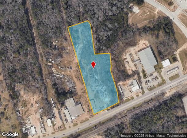
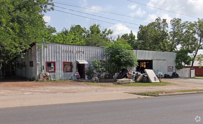
Property Record
1200 E Davis St, Conroe, TX 77301

NEARBY LISTINGS FOR SALE OR LEASE
Property Detail
1200 E Davis St
0526-01-00700
Smith Lemuel
Commercialnec
A0526 - SMITH LEMUEL, TRACT 7, 49, ACRES 0.4806
AE
Montgomery
48339C0380G
Texas
2024
0.48 AC
2025
Montgomery County
693903
Houston
7,424 SF
Houston-Pasadena-The Woodlands, TX
DEMOGRAPHICS near 1200 E Davis St
1 Mile
3 Mile
5 Mile
2024 Total Population
9,238
56,456
89,235
2029 Population
11,306
68,797
109,335
Pop Growth 2024-2029
+ 22.39%
+ 21.86%
+ 22.52%
Average Age
34
35
36
2024 Total Households
2,793
19,588
31,267
HH Growth 2024-2029
+ 22.48%
+ 22.71%
+ 23.12%
Median Household Inc
$42,602
$53,675
$65,571
Avg Household Size
3.10
2.70
2.70
2024 Avg HH Vehicles
2.00
2.00
2.00
Median Home Value
$89,988
$200,703
$250,816
Median Year Built
1983
1995
2000
Nearby Places
Map Layers
Map Styles
 Street
 Aerial
- Restaurants
- Banks
- Shops
- Fitness
- Groceries
PUBLIC TRANSPORTATION
AIRPORT
George Bush Intcntl/Houston
DRIVE
WALK
Distance
George Bush Intcntl/Houston
41 min
32.7 mi
Freight Ports
Port of Houston
DRIVE
WALK
Distance
Port of Houston
64 min
48.4 mi
SALE & LEASE HISTORY
LISTING DATE
SALE/LEASE

Nov 17, 2016
For Lease
Nearby Properties
Address
Land Use
TOTAL SIZE
Lot Size
Zoning
Address
Land Use
TOTAL SIZE
Lot Size
Zoning
322,082 SF
36.56 AC
1
Address
Land Use
TOTAL SIZE
Lot Size
Zoning
398,842 SF
23.75 AC
1
Address
Land Use
TOTAL SIZE
Lot Size
Zoning
470,259 SF
27.98 AC
1
Address
Land Use
TOTAL SIZE
Lot Size
Zoning
619,770 SF
81.76 AC
Address
Land Use
TOTAL SIZE
Lot Size
Zoning
354,000 SF
13.81 AC
Address
Land Use
TOTAL SIZE
Lot Size
Zoning
361,388 SF
16.32 AC
Address
Land Use
TOTAL SIZE
Lot Size
Zoning
191,700 SF
19.41 AC
1
Address
Land Use
TOTAL SIZE
Lot Size
Zoning
284,451 SF
13.66 AC
1
Address
Land Use
TOTAL SIZE
Lot Size
Zoning
326,478 SF
20.22 AC
Address
Land Use
TOTAL SIZE
Lot Size
Zoning
366,709 SF
27.72 AC
Address
Land Use
TOTAL SIZE
Lot Size
Zoning
258,100 SF
12.04 AC
1
Address
Land Use
TOTAL SIZE
Lot Size
Zoning
195,956 SF
1.76 AC
1
Address
Land Use
TOTAL SIZE
Lot Size
Zoning
206,008 SF
107.61 AC
Address
Land Use
TOTAL SIZE
Lot Size
Zoning
211,275 SF
12.58 AC
Address
Land Use
TOTAL SIZE
Lot Size
Zoning
191,006 SF
9.19 AC
Address
Land Use
TOTAL SIZE
Lot Size
Zoning
142,800 SF
7.82 AC
Address
Land Use
TOTAL SIZE
Lot Size
Zoning
136,300 SF
9.08 AC
1
Address
Land Use
TOTAL SIZE
Lot Size
Zoning
89,298 SF
9.22 AC
Address
Land Use
TOTAL SIZE
Lot Size
Zoning
590,471 SF
32.21 AC
Address
Land Use
TOTAL SIZE
Lot Size
Zoning
197,533 SF
58.31 AC
Address
Land Use
TOTAL SIZE
Lot Size
Zoning
175,476 SF
8.03 AC
1
Address
Land Use
TOTAL SIZE
Lot Size
Zoning
171,124 SF
9.03 AC
1
Address
Land Use
TOTAL SIZE
Lot Size
Zoning
75,048 SF
10.59 AC
Address
Land Use
TOTAL SIZE
Lot Size
Zoning
376,980 SF
24.37 AC
1
Address
Land Use
TOTAL SIZE
Lot Size
Zoning
242,944 SF
179.58 AC
Address
Land Use
TOTAL SIZE
Lot Size
Zoning
70,010 SF
8.89 AC
Address
Land Use
TOTAL SIZE
Lot Size
Zoning
174,324 SF
6.66 AC
1
Address
Land Use
TOTAL SIZE
Lot Size
Zoning
94,950 SF
7.41 AC
1
Address
Land Use
TOTAL SIZE
Lot Size
Zoning
148,906 SF
7.05 AC
1
Address
Land Use
TOTAL SIZE
Lot Size
Zoning
332,274 SF
40 AC
The World's #1 Commercial Real Estate Marketplace
Connect with us
© 2026 CoStar Group
The information above has been obtained from sources believed reliable. While we do not doubt its accuracy we have not verified it and make no guarantee, warranty or representation about it. It is your responsibility to independently confirm its accuracy and completeness. Any projections, opinions, assumptions, or estimates used are for example only and do not represent the current or future performance of the property. The value of this transaction to you depends on tax and other factors which should be evaluated by your tax, financial, and legal advisors. You and your advisors should conduct a careful, independent investigation of the property to determine to your satisfaction the suitability of the property for your needs.