Property Record
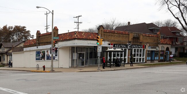
1200 E Oklahoma Ave, Milwaukee, WI 53207


Property Detail
1200 E Oklahoma Ave
504-0108-000-4
CHARLOTTES SUBD IN SE 1/4 SEC 9-6-22 BLOCK 1 LOTS 8 & 9 & W 8 LOT 7
Storemultistory
MILWAUKEE
LB2
Wisconsin
B and X Area of moderate flood hazard, usually the area between the limits of the 100-year and 500-year floods.
8,9,7
2024
0.25 AC
2024
Milwaukee SE
018300
Milwaukee/Madison
5,960 SF
Milwaukee-Waukesha, WI
NEARBY LISTINGS FOR SALE OR LEASE
DEMOGRAPHICS near 1200 E Oklahoma Ave
1 mile
3 mile
5 mile
2025 Total Population
18,355
112,783
286,739
2030 Population
17,921
109,866
282,932
Pop Growth 2025-2030
(2.36%)
(2.59%)
(1.33%)
Average Age
40
37
37
2025 Total Households
9,008
45,454
123,956
HH Growth 2025-2030
(2.48%)
(2.34%)
(1.02%)
Median Household Inc
$91,708
$61,092
$59,014
Avg Household Size
2.00
2.40
2.20
2025 Avg HH Vehicles
2.00
2.00
1.00
Median Home Value
$273,227
$206,163
$217,263
Median Year Built
1946
1948
1953
Nearby Places
Map Layers
Map Styles
 Street
 Aerial
Layers
 Traffic
 Biking
Places
Listings with unknown addresses are not visible on the map
- Restaurants
- Banks
- Shops
- Fitness
- Groceries
PUBLIC TRANSPORTATION
COMMUTER RAIL
Drive
Walk
Distance
12 min
4.4 mi
Drive
Walk
Distance
9 min
4.9 mi
AIRPORT
General Mitchell International
Drive
Walk
Distance
General Mitchell International
10 min
3.7 mi
SALE & LEASE HISTORY
LISTING DATE
SALE/LEASE

Sep 25, 2016
For Lease
Jan 14, 2019
For Sale
Jan 12, 2018
For Sale
Dec 19, 2017
For Lease
Nearby Properties
Address
Land Use
TOTAL SIZE
Lot Size
Zoning
Address
Land Use
TOTAL SIZE
Lot Size
Zoning
41.05 AC
IO2
Address
Land Use
TOTAL SIZE
Lot Size
Zoning
319,559 SF
6.29 AC
PD
Address
Land Use
TOTAL SIZE
Lot Size
Zoning
179 AC
IH
Address
Land Use
TOTAL SIZE
Lot Size
Zoning
Address
Land Use
TOTAL SIZE
Lot Size
Zoning
11.09 AC
Address
Land Use
TOTAL SIZE
Lot Size
Zoning
204,809 SF
1.04 AC
IM
Address
Land Use
TOTAL SIZE
Lot Size
Zoning
245,485 SF
6.30 AC
IM
Address
Land Use
TOTAL SIZE
Lot Size
Zoning
12.02 AC
IO2
Address
Land Use
TOTAL SIZE
Lot Size
Zoning
48.34 AC
IO1
Address
Land Use
TOTAL SIZE
Lot Size
Zoning
2,610 SF
1.04 AC
IM
Address
Land Use
TOTAL SIZE
Lot Size
Zoning
2.85 AC
C9G
Address
Land Use
TOTAL SIZE
Lot Size
Zoning
86.13 AC
IH
Address
Land Use
TOTAL SIZE
Lot Size
Zoning
11.38 AC
TL
Address
Land Use
TOTAL SIZE
Lot Size
Zoning
120,000 SF
1.10 AC
IM
Address
Land Use
TOTAL SIZE
Lot Size
Zoning
222,100 SF
1.29 AC
PD
Address
Land Use
TOTAL SIZE
Lot Size
Zoning
197,354 SF
18 AC
CS
Address
Land Use
TOTAL SIZE
Lot Size
Zoning
0.43 AC
RT3
Address
Land Use
TOTAL SIZE
Lot Size
Zoning
183,291 SF
11.48 AC
IM
Address
Land Use
TOTAL SIZE
Lot Size
Zoning
95,788 SF
1.04 AC
IM
Address
Land Use
TOTAL SIZE
Lot Size
Zoning
Address
Land Use
TOTAL SIZE
Lot Size
Zoning
122,602 SF
0.89 AC
IM
Address
Land Use
TOTAL SIZE
Lot Size
Zoning
216,289 SF
1.06 AC
IM
Address
Land Use
TOTAL SIZE
Lot Size
Zoning
83,827 SF
2.07 AC
PD
Address
Land Use
TOTAL SIZE
Lot Size
Zoning
76.97 AC
IH
Address
Land Use
TOTAL SIZE
Lot Size
Zoning
360,000 SF
14.60 AC
IL1
Address
Land Use
TOTAL SIZE
Lot Size
Zoning
118,419 SF
0.88 AC
IM
Address
Land Use
TOTAL SIZE
Lot Size
Zoning
20.49 AC
TL
Address
Land Use
TOTAL SIZE
Lot Size
Zoning
85,200 SF
1.74 AC
IM
Address
Land Use
TOTAL SIZE
Lot Size
Zoning
152,130 SF
7.68 AC
PD
Address
Land Use
TOTAL SIZE
Lot Size
Zoning
205,632 SF
18 AC
PD
The World's #1 Commercial Real Estate Marketplace
Connect with us
© 2026 CoStar Group
The information above has been obtained from sources believed reliable. While we do not doubt its accuracy we have not verified it and make no guarantee, warranty or representation about it. It is your responsibility to independently confirm its accuracy and completeness. Any projections, opinions, assumptions, or estimates used are for example only and do not represent the current or future performance of the property. The value of this transaction to you depends on tax and other factors which should be evaluated by your tax, financial, and legal advisors. You and your advisors should conduct a careful, independent investigation of the property to determine to your satisfaction the suitability of the property for your needs.