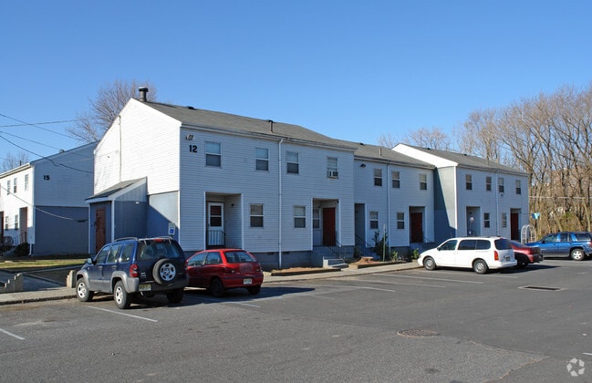
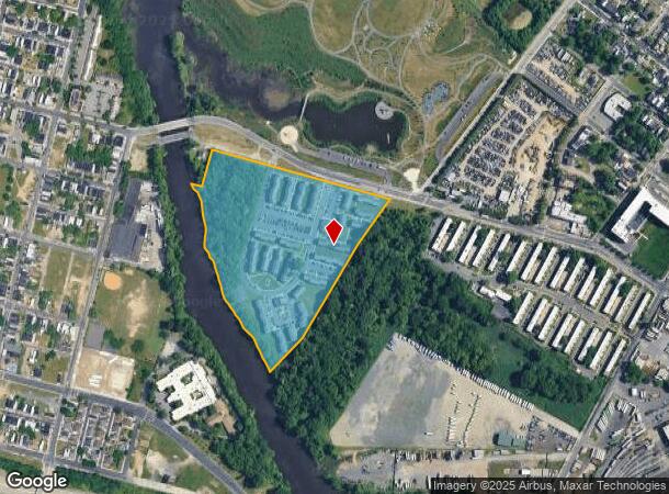
Property Record
1200 E State St, Camden, NJ 08105


NEARBY LISTINGS FOR SALE OR LEASE
Property Detail
1200 E State St
Philadelphia-Camden-Wilmington, PA-NJ-DE-MD
ADDITIONAL LOTS: CENTENNIAL VILLAGE
08-00807-0000-00006
Camden
Apartment
New Jersey
AE
6
34007C0028F
26.59 AC
2024
Cramer Hill
2025
Philadelphia
601101
DEMOGRAPHICS near 1200 E State St
1 Mile
3 Mile
5 Mile
2024 Total Population
17,776
275,236
829,577
2029 Population
17,996
272,868
815,772
Pop Growth 2024-2029
+ 1.24%
(0.86%)
(1.66%)
Average Age
35
37
37
2024 Total Households
5,862
116,551
342,636
HH Growth 2024-2029
+ 1.26%
(1.22%)
(1.93%)
Median Household Inc
$28,568
$68,664
$59,377
Avg Household Size
2.70
2.20
2.30
2024 Avg HH Vehicles
1.00
1.00
1.00
Median Home Value
$127,397
$288,247
$258,301
Median Year Built
1948
1950
1948
Nearby Places
Map Layers
Map Styles
 Street
 Aerial
- Restaurants
- Banks
- Shops
- Fitness
- Groceries
PUBLIC TRANSPORTATION
COMMUTER RAIL
Market East (R1 - Southeastern Pennsylvania Transportation Authority Regional Rail (SEPTA Regional Rail), R2 - Southeastern Pennsylvania Transportation Authority Regional Rail (SEPTA Regional Rail), R3 - Southeastern Pennsylvania Transportation Authority Regional Rail (SEPTA Regional Rail), R5 - Southeastern Pennsylvania Transportation Authority Regional Rail (SEPTA Regional Rail), R6 - Southeastern Pennsylvania Transportation Authority Regional Rail (SEPTA Regional Rail), R7 - Southeastern Pennsylvania Transportation Authority Regional Rail (SEPTA Regional Rail), R8 - Southeastern Pennsylvania Transportation Authority Regional Rail (SEPTA Regional Rail))
DRIVE
WALK
Distance
Market East (R1 - Southeastern Pennsylvania Transportation Authority Regional Rail (SEPTA Regional Rail), R2 - Southeastern Pennsylvania Transportation Authority Regional Rail (SEPTA Regional Rail), R3 - Southeastern Pennsylvania Transportation Authority Regional Rail (SEPTA Regional Rail), R5 - Southeastern Pennsylvania Transportation Authority Regional Rail (SEPTA Regional Rail), R6 - Southeastern Pennsylvania Transportation Authority Regional Rail (SEPTA Regional Rail), R7 - Southeastern Pennsylvania Transportation Authority Regional Rail (SEPTA Regional Rail), R8 - Southeastern Pennsylvania Transportation Authority Regional Rail (SEPTA Regional Rail))
7 min
3.4 mi
Pennsauken Transit Center (Atlantic City Rail Line - NJ TRANSIT RAIL)
DRIVE
WALK
Distance
Pennsauken Transit Center (Atlantic City Rail Line - NJ TRANSIT RAIL)
7 min
3.8 mi
AIRPORT
Philadelphia International
DRIVE
WALK
Distance
Philadelphia International
25 min
14.7 mi
Trenton Mercer
DRIVE
WALK
Distance
Trenton Mercer
52 min
35.3 mi
Freight Ports
South Jersey Port
DRIVE
WALK
Distance
South Jersey Port
5 min
2.2 mi
Nearby Properties
Address
Land Use
TOTAL SIZE
Lot Size
Zoning
Address
Land Use
TOTAL SIZE
Lot Size
Zoning
1,296,804 SF
2.71 AC
I2
Address
Land Use
TOTAL SIZE
Lot Size
Zoning
880,950 SF
27.71 AC
SPENT
Address
Land Use
TOTAL SIZE
Lot Size
Zoning
624,696 SF
5.79 AC
CMX4
Address
Land Use
TOTAL SIZE
Lot Size
Zoning
1,075,580 SF
2.65 AC
CMX5
Address
Land Use
TOTAL SIZE
Lot Size
Zoning
1.17 AC
Address
Land Use
TOTAL SIZE
Lot Size
Zoning
7.17 AC
Address
Land Use
TOTAL SIZE
Lot Size
Zoning
1,102,992 SF
2.14 AC
CMX5
Address
Land Use
TOTAL SIZE
Lot Size
Zoning
665,742 SF
0.98 AC
CMX4
Address
Land Use
TOTAL SIZE
Lot Size
Zoning
124.13 AC
Address
Land Use
TOTAL SIZE
Lot Size
Zoning
1,011,079 SF
5.82 AC
CMX5
Address
Land Use
TOTAL SIZE
Lot Size
Zoning
728,244 SF
5.56 AC
CMX4
Address
Land Use
TOTAL SIZE
Lot Size
Zoning
63,402 SF
0.71 AC
CMX4
Address
Land Use
TOTAL SIZE
Lot Size
Zoning
804,000 SF
4.29 AC
CMX3
Address
Land Use
TOTAL SIZE
Lot Size
Zoning
723,780 SF
1.15 AC
CMX5
Address
Land Use
TOTAL SIZE
Lot Size
Zoning
891,135 SF
7.59 AC
CMX5
Address
Land Use
TOTAL SIZE
Lot Size
Zoning
747,200 SF
0.69 AC
CMX5
Address
Land Use
TOTAL SIZE
Lot Size
Zoning
363,801 SF
2.59 AC
CMX4
Address
Land Use
TOTAL SIZE
Lot Size
Zoning
12.53 AC
Address
Land Use
TOTAL SIZE
Lot Size
Zoning
139,992 SF
5.64 AC
SPPOA
Address
Land Use
TOTAL SIZE
Lot Size
Zoning
322,000 SF
7.44 AC
CMX3
Address
Land Use
TOTAL SIZE
Lot Size
Zoning
816,208 SF
2.98 AC
CMX4
Address
Land Use
TOTAL SIZE
Lot Size
Zoning
449,820 SF
0.42 AC
CMX5
Address
Land Use
TOTAL SIZE
Lot Size
Zoning
213,823 SF
2.01 AC
CMX5
Address
Land Use
TOTAL SIZE
Lot Size
Zoning
728,244 SF
5.57 AC
CMX4
Address
Land Use
TOTAL SIZE
Lot Size
Zoning
1.62 AC
Address
Land Use
TOTAL SIZE
Lot Size
Zoning
224,000 SF
0.90 AC
CMX4
Address
Land Use
TOTAL SIZE
Lot Size
Zoning
332,444 SF
1.32 AC
CMX3
Address
Land Use
TOTAL SIZE
Lot Size
Zoning
169,220 SF
2.01 AC
SPINS
Address
Land Use
TOTAL SIZE
Lot Size
Zoning
256,688 SF
1.46 AC
RMX3
Address
Land Use
TOTAL SIZE
Lot Size
Zoning
447,070 SF
0.78 AC
CMX5
The World's #1 Commercial Real Estate Marketplace
Connect with us
© 2025 CoStar Group
The information above has been obtained from sources believed reliable. While we do not doubt its accuracy we have not verified it and make no guarantee, warranty or representation about it. It is your responsibility to independently confirm its accuracy and completeness. Any projections, opinions, assumptions, or estimates used are for example only and do not represent the current or future performance of the property. The value of this transaction to you depends on tax and other factors which should be evaluated by your tax, financial, and legal advisors. You and your advisors should conduct a careful, independent investigation of the property to determine to your satisfaction the suitability of the property for your needs.