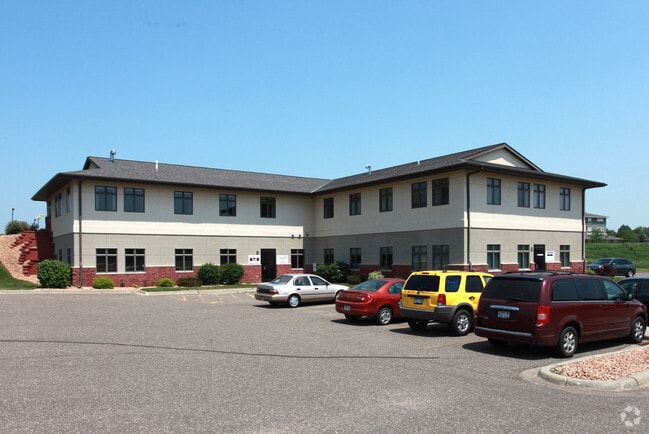
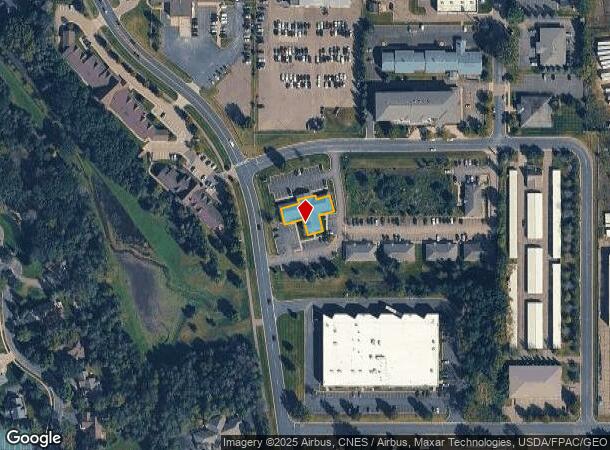
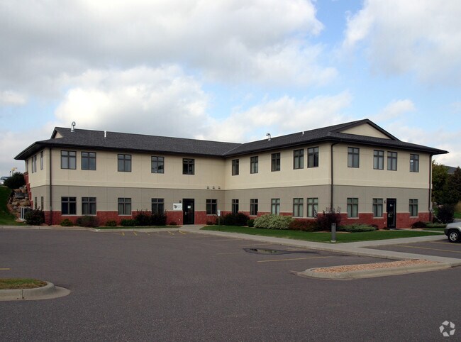
Property Record
1200 Hosford St, Hudson, WI 54016
Current Lease Availabilities
NEARBY LISTINGS FOR SALE OR LEASE
Property Detail
1200 Hosford St
Minneapolis-St. Paul-Bloomington, MN-WI
River Ridge Professional Center Condomin
236-1761-01-023
UNIT 4 RIVER RIDGE PROFESSIONAL CENTER CONDOMINIUM
Commercialnec
St Croix
X
Wisconsin
55093C0025E
4
2025
1.65 AC
2024
St Croix County
120905
Minneapolis/St Paul
2,061 SF
DEMOGRAPHICS near 1200 Hosford St
1 Mile
3 Mile
5 Mile
2024 Total Population
6,447
25,128
41,098
2029 Population
6,937
27,072
44,379
Pop Growth 2024-2029
+ 7.60%
+ 7.74%
+ 7.98%
Average Age
40
42
42
2024 Total Households
2,765
10,309
16,152
HH Growth 2024-2029
+ 7.67%
+ 7.78%
+ 8.02%
Median Household Inc
$81,037
$98,574
$112,323
Avg Household Size
2.30
2.40
2.50
2024 Avg HH Vehicles
2.00
2.00
2.00
Median Home Value
$292,158
$348,925
$385,008
Median Year Built
1994
1993
1992
Nearby Places
Map Layers
Map Styles
 Street
 Aerial
- Restaurants
- Banks
- Shops
- Fitness
- Groceries
PUBLIC TRANSPORTATION
AIRPORT
Minneapolis-St Paul International/Wold-Chamberlain
DRIVE
WALK
Distance
Minneapolis-St Paul International/Wold-Chamberlain
38 min
27.8 mi
Nearby Properties
Address
Land Use
TOTAL SIZE
Lot Size
Zoning
Address
Land Use
TOTAL SIZE
Lot Size
Zoning
10.90 AC
Address
Land Use
TOTAL SIZE
Lot Size
Zoning
404,968 SF
29.93 AC
I-1
Address
Land Use
TOTAL SIZE
Lot Size
Zoning
3.78 AC
Address
Land Use
TOTAL SIZE
Lot Size
Zoning
255,000 SF
16.74 AC
I-1
Address
Land Use
TOTAL SIZE
Lot Size
Zoning
7.66 AC
Address
Land Use
TOTAL SIZE
Lot Size
Zoning
124,739 SF
10.26 AC
B-2
Address
Land Use
TOTAL SIZE
Lot Size
Zoning
12,271 SF
8.56 AC
B-2
Address
Land Use
TOTAL SIZE
Lot Size
Zoning
100,892 SF
11.32 AC
I-1
Address
Land Use
TOTAL SIZE
Lot Size
Zoning
66,516 SF
5 AC
PRD-2
Address
Land Use
TOTAL SIZE
Lot Size
Zoning
3.68 AC
Address
Land Use
TOTAL SIZE
Lot Size
Zoning
0.90 AC
Address
Land Use
TOTAL SIZE
Lot Size
Zoning
63,024 SF
4.70 AC
Address
Land Use
TOTAL SIZE
Lot Size
Zoning
20,845 SF
4.01 AC
B-2
Address
Land Use
TOTAL SIZE
Lot Size
Zoning
20,456 SF
13.93 AC
B-2
Address
Land Use
TOTAL SIZE
Lot Size
Zoning
43,342 SF
8.11 AC
B-2
Address
Land Use
TOTAL SIZE
Lot Size
Zoning
92,971 SF
9.56 AC
B-2
Address
Land Use
TOTAL SIZE
Lot Size
Zoning
23,461 SF
9.30 AC
Address
Land Use
TOTAL SIZE
Lot Size
Zoning
28,805 SF
1.67 AC
B-2
Address
Land Use
TOTAL SIZE
Lot Size
Zoning
12,612 SF
4 AC
RM-1
Address
Land Use
TOTAL SIZE
Lot Size
Zoning
86,279 SF
8.46 AC
B-2
Address
Land Use
TOTAL SIZE
Lot Size
Zoning
41,976 SF
2.43 AC
B-2
Address
Land Use
TOTAL SIZE
Lot Size
Zoning
580 SF
1.72 AC
B-2
Address
Land Use
TOTAL SIZE
Lot Size
Zoning
55,072 SF
6.33 AC
B-2
Address
Land Use
TOTAL SIZE
Lot Size
Zoning
18,848 SF
4.41 AC
RM-1
Address
Land Use
TOTAL SIZE
Lot Size
Zoning
Address
Land Use
TOTAL SIZE
Lot Size
Zoning
25,272 SF
3.60 AC
RM-1
Address
Land Use
TOTAL SIZE
Lot Size
Zoning
11,576 SF
3.86 AC
B-2
Address
Land Use
TOTAL SIZE
Lot Size
Zoning
22,788 SF
3.38 AC
Address
Land Use
TOTAL SIZE
Lot Size
Zoning
34,676 SF
2.96 AC
Address
Land Use
TOTAL SIZE
Lot Size
Zoning
18,160 SF
3.38 AC
OFC
The World's #1 Commercial Real Estate Marketplace
Connect with us
© 2026 CoStar Group
The information above has been obtained from sources believed reliable. While we do not doubt its accuracy we have not verified it and make no guarantee, warranty or representation about it. It is your responsibility to independently confirm its accuracy and completeness. Any projections, opinions, assumptions, or estimates used are for example only and do not represent the current or future performance of the property. The value of this transaction to you depends on tax and other factors which should be evaluated by your tax, financial, and legal advisors. You and your advisors should conduct a careful, independent investigation of the property to determine to your satisfaction the suitability of the property for your needs.