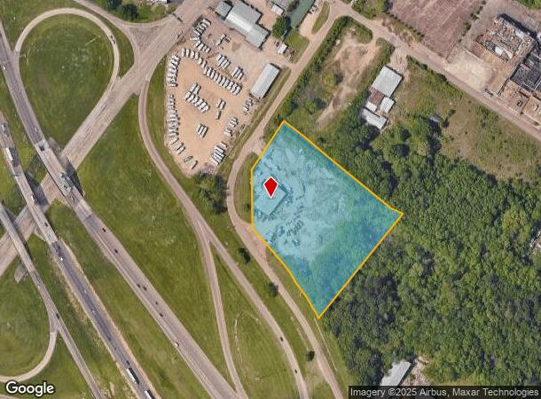
Property Record
1200 I 20 Frontage Rd, Jackson, MS 39204

NEARBY LISTINGS FOR SALE OR LEASE
Property Detail
1200 I 20 Frontage Rd
Jackson, MS
Wilmington Subdivision
0201-0095-000
LEASEHOLD INT IN THE FOLLOWING: BEG SW COR LOT 21 WILMINGTON SUBN NW/LY 860.5 FT TO POB W/LY 53.23 FT NW/LY 488.2 FT SW/LY 85.38 FT NW/LY 2.2 FT SW/LY 137.63 FT S 193.4 FT SE/LY 376.45 FT S/LY 100.72 FT NE/LY 508.7 FT TO POB PT NW 1/4 SEC 16 T5N R1E
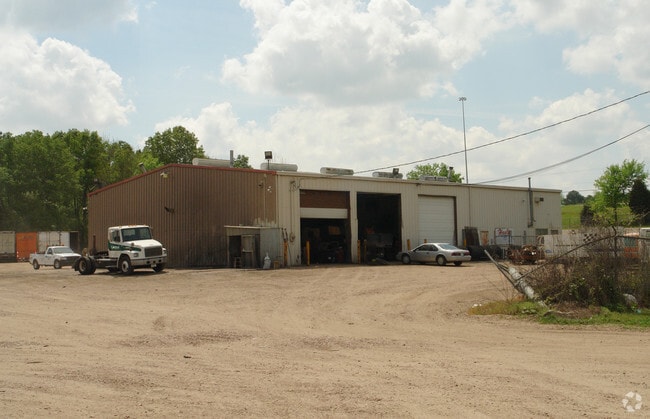
Autorepair
Hinds
X
Mississippi
28121C0164G
21
2024
4 AC
2025
South Jackson
003000
Jackson
7,313 SF
DEMOGRAPHICS near 1200 I 20 Frontage Rd
1 Mile
3 Mile
5 Mile
2024 Total Population
5,324
47,069
93,327
2029 Population
5,259
46,033
90,745
Pop Growth 2024-2029
(1.22%)
(2.20%)
(2.77%)
Average Age
35
36
37
2024 Total Households
1,959
18,845
38,456
HH Growth 2024-2029
(0.92%)
(2.23%)
(2.89%)
Median Household Inc
$32,016
$29,001
$30,815
Avg Household Size
2.50
2.30
2.30
2024 Avg HH Vehicles
2.00
2.00
2.00
Median Home Value
$55,240
$60,250
$71,522
Median Year Built
1957
1965
1967
Nearby Places
Map Layers
Map Styles
 Street
 Aerial
- Restaurants
- Banks
- Shops
- Fitness
- Groceries
PUBLIC TRANSPORTATION
COMMUTER RAIL
DRIVE
WALK
Distance
5 min
2.1 mi
AIRPORT
Jackson-Medgar Wiley Evers International
DRIVE
WALK
Distance
Jackson-Medgar Wiley Evers International
19 min
12.1 mi
Nearby Properties
Address
Land Use
TOTAL SIZE
Lot Size
Zoning
Address
Land Use
TOTAL SIZE
Lot Size
Zoning
435,199 SF
1 AC
Address
Land Use
TOTAL SIZE
Lot Size
Zoning
74,923 SF
0.01 AC
Address
Land Use
TOTAL SIZE
Lot Size
Zoning
191,128 SF
29.57 AC
Address
Land Use
TOTAL SIZE
Lot Size
Zoning
9,650 SF
0.55 AC
Address
Land Use
TOTAL SIZE
Lot Size
Zoning
7.60 AC
Address
Land Use
TOTAL SIZE
Lot Size
Zoning
Address
Land Use
TOTAL SIZE
Lot Size
Zoning
145,789 SF
6 AC
Address
Land Use
TOTAL SIZE
Lot Size
Zoning
192,048 SF
23.70 AC
Address
Land Use
TOTAL SIZE
Lot Size
Zoning
413,174 SF
2 AC
Address
Land Use
TOTAL SIZE
Lot Size
Zoning
96,444 SF
0.88 AC
Address
Land Use
TOTAL SIZE
Lot Size
Zoning
45,186 SF
0.15 AC
Address
Land Use
TOTAL SIZE
Lot Size
Zoning
115,200 SF
0.35 AC
Address
Land Use
TOTAL SIZE
Lot Size
Zoning
46,958 SF
0.77 AC
Address
Land Use
TOTAL SIZE
Lot Size
Zoning
2,190,610 SF
2 AC
Address
Land Use
TOTAL SIZE
Lot Size
Zoning
545,127 SF
36 AC
Address
Land Use
TOTAL SIZE
Lot Size
Zoning
62,857 SF
4.79 AC
Address
Land Use
TOTAL SIZE
Lot Size
Zoning
47,885 SF
0.01 AC
Address
Land Use
TOTAL SIZE
Lot Size
Zoning
69,034 SF
0.64 AC
Address
Land Use
TOTAL SIZE
Lot Size
Zoning
9,081 SF
0.73 AC
Address
Land Use
TOTAL SIZE
Lot Size
Zoning
55,591 SF
1 AC
Address
Land Use
TOTAL SIZE
Lot Size
Zoning
42,520 SF
0.22 AC
Address
Land Use
TOTAL SIZE
Lot Size
Zoning
0.01 AC
Address
Land Use
TOTAL SIZE
Lot Size
Zoning
Address
Land Use
TOTAL SIZE
Lot Size
Zoning
72,000 SF
0.01 AC
Address
Land Use
TOTAL SIZE
Lot Size
Zoning
38,189 SF
1 AC
Address
Land Use
TOTAL SIZE
Lot Size
Zoning
Address
Land Use
TOTAL SIZE
Lot Size
Zoning
76,780 SF
4 AC
Address
Land Use
TOTAL SIZE
Lot Size
Zoning
8.37 AC
Address
Land Use
TOTAL SIZE
Lot Size
Zoning
Address
Land Use
TOTAL SIZE
Lot Size
Zoning
The World's #1 Commercial Real Estate Marketplace
Connect with us
© 2026 CoStar Group
The information above has been obtained from sources believed reliable. While we do not doubt its accuracy we have not verified it and make no guarantee, warranty or representation about it. It is your responsibility to independently confirm its accuracy and completeness. Any projections, opinions, assumptions, or estimates used are for example only and do not represent the current or future performance of the property. The value of this transaction to you depends on tax and other factors which should be evaluated by your tax, financial, and legal advisors. You and your advisors should conduct a careful, independent investigation of the property to determine to your satisfaction the suitability of the property for your needs.