Property Record
1200 Matthew St, Watsontown, PA 17777

NEARBY LISTINGS FOR SALE OR LEASE
-
-
View all Watsontown listings for lease on LoopNet.com
Property Detail
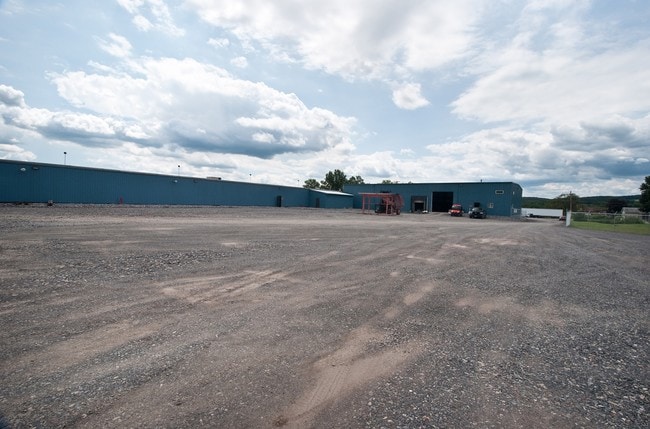
1200 Matthew St
Sunbury, PA
Plot #4 Of The L M Fromme Addition
061-00-010-003-A
19.821 AC
Industrialgeneral
Northumberland
AE
Pennsylvania
42097C0105D
19.82 AC
2025
Pennsylvania Central Area
2025
Other Market Areas
080200
DEMOGRAPHICS near 1200 Matthew St
1 Mile
3 Mile
5 Mile
2024 Total Population
3,234
6,403
15,960
2029 Population
3,123
6,167
15,566
Pop Growth 2024-2029
(3.43%)
(3.69%)
(2.47%)
Average Age
44
44
44
2024 Total Households
1,383
2,649
5,233
HH Growth 2024-2029
(3.62%)
(3.96%)
(3.23%)
Median Household Inc
$48,349
$51,480
$53,219
Avg Household Size
2.30
2.30
2.40
2024 Avg HH Vehicles
2.00
2.00
2.00
Median Home Value
$167,615
$178,120
$182,130
Median Year Built
1956
1966
1970
Nearby Places
Map Layers
Map Styles
 Street
 Aerial
- Restaurants
- Banks
- Shops
- Fitness
- Groceries
SALE & LEASE HISTORY
LISTING DATE
SALE/LEASE

Sep 25, 2016
For Lease
Nearby Properties
Address
Land Use
TOTAL SIZE
Lot Size
Zoning
Address
Land Use
TOTAL SIZE
Lot Size
Zoning
4,844 AC
Address
Land Use
TOTAL SIZE
Lot Size
Zoning
34 AC
CM
Address
Land Use
TOTAL SIZE
Lot Size
Zoning
69.64 AC
CM
Address
Land Use
TOTAL SIZE
Lot Size
Zoning
38.17 AC
CM
Address
Land Use
TOTAL SIZE
Lot Size
Zoning
43.16 AC
Address
Land Use
TOTAL SIZE
Lot Size
Zoning
9.88 AC
CM
Address
Land Use
TOTAL SIZE
Lot Size
Zoning
21.91 AC
Address
Land Use
TOTAL SIZE
Lot Size
Zoning
10.70 AC
CM
Address
Land Use
TOTAL SIZE
Lot Size
Zoning
23 AC
CM
Address
Land Use
TOTAL SIZE
Lot Size
Zoning
16.94 AC
Address
Land Use
TOTAL SIZE
Lot Size
Zoning
13 AC
CM
Address
Land Use
TOTAL SIZE
Lot Size
Zoning
6.30 AC
Address
Land Use
TOTAL SIZE
Lot Size
Zoning
Address
Land Use
TOTAL SIZE
Lot Size
Zoning
3.01 AC
Address
Land Use
TOTAL SIZE
Lot Size
Zoning
13.43 AC
Address
Land Use
TOTAL SIZE
Lot Size
Zoning
16.55 AC
Address
Land Use
TOTAL SIZE
Lot Size
Zoning
Address
Land Use
TOTAL SIZE
Lot Size
Zoning
53.50 AC
Address
Land Use
TOTAL SIZE
Lot Size
Zoning
42.38 AC
Address
Land Use
TOTAL SIZE
Lot Size
Zoning
0.35 AC
Address
Land Use
TOTAL SIZE
Lot Size
Zoning
Address
Land Use
TOTAL SIZE
Lot Size
Zoning
34.36 AC
Address
Land Use
TOTAL SIZE
Lot Size
Zoning
3.50 AC
CM
Address
Land Use
TOTAL SIZE
Lot Size
Zoning
16.18 AC
V
Address
Land Use
TOTAL SIZE
Lot Size
Zoning
1.57 AC
C
Address
Land Use
TOTAL SIZE
Lot Size
Zoning
29.73 AC
Address
Land Use
TOTAL SIZE
Lot Size
Zoning
2.79 AC
C
Address
Land Use
TOTAL SIZE
Lot Size
Zoning
4.92 AC
CM
Address
Land Use
TOTAL SIZE
Lot Size
Zoning
2.04 AC
C
Address
Land Use
TOTAL SIZE
Lot Size
Zoning
28.33 AC
The World's #1 Commercial Real Estate Marketplace
Connect with us
© 2026 CoStar Group
The information above has been obtained from sources believed reliable. While we do not doubt its accuracy we have not verified it and make no guarantee, warranty or representation about it. It is your responsibility to independently confirm its accuracy and completeness. Any projections, opinions, assumptions, or estimates used are for example only and do not represent the current or future performance of the property. The value of this transaction to you depends on tax and other factors which should be evaluated by your tax, financial, and legal advisors. You and your advisors should conduct a careful, independent investigation of the property to determine to your satisfaction the suitability of the property for your needs.