Property Record
1200 Military Rd, Benton, AR 72015


NEARBY LISTINGS FOR SALE OR LEASE
Property Detail
1200 Military Rd
805-15201-000
PT SWSE2004-30764
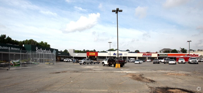
Regionalshoppingcenterormallwithanchorstore
Saline
X
Arkansas
05125C0355E
2.46 AC
2025
Saline County
2025
Little Rock/N Little Rock
010601
Little Rock-North Little Rock-Conway, AR
38,008 SF
DEMOGRAPHICS near 1200 Military Rd
1 Mile
3 Mile
5 Mile
2024 Total Population
6,353
33,973
51,947
2029 Population
6,872
36,737
56,171
Pop Growth 2024-2029
+ 8.17%
+ 8.14%
+ 8.13%
Average Age
38
39
39
2024 Total Households
2,532
13,458
20,727
HH Growth 2024-2029
+ 8.33%
+ 8.29%
+ 8.23%
Median Household Inc
$62,770
$65,049
$66,686
Avg Household Size
2.40
2.50
2.50
2024 Avg HH Vehicles
2.00
2.00
2.00
Median Home Value
$137,531
$174,453
$190,480
Median Year Built
1970
1990
1993
Nearby Places
Map Layers
Map Styles
 Street
 Aerial
- Restaurants
- Banks
- Shops
- Fitness
- Groceries
PUBLIC TRANSPORTATION
AIRPORT
Bill and Hillary Clinton Ntl/Adams Field
DRIVE
WALK
Distance
Bill and Hillary Clinton Ntl/Adams Field
31 min
24.6 mi
SALE & LEASE HISTORY
LISTING DATE
SALE/LEASE

Sep 30, 2016
For Lease
Sep 23, 2016
For Sale
Dec 29, 2017
For Lease
Nearby Properties
Address
Land Use
TOTAL SIZE
Lot Size
Zoning
Address
Land Use
TOTAL SIZE
Lot Size
Zoning
32,067 SF
26.67 AC
Address
Land Use
TOTAL SIZE
Lot Size
Zoning
297,680 SF
16.96 AC
Address
Land Use
TOTAL SIZE
Lot Size
Zoning
137,445 SF
28.75 AC
Address
Land Use
TOTAL SIZE
Lot Size
Zoning
98,702 SF
0.67 AC
Address
Land Use
TOTAL SIZE
Lot Size
Zoning
75,795 SF
9.39 AC
Address
Land Use
TOTAL SIZE
Lot Size
Zoning
90,200 SF
17.30 AC
Address
Land Use
TOTAL SIZE
Lot Size
Zoning
60,030 SF
6.51 AC
Address
Land Use
TOTAL SIZE
Lot Size
Zoning
43,055 SF
3.94 AC
Address
Land Use
TOTAL SIZE
Lot Size
Zoning
78,845 SF
15.44 AC
Address
Land Use
TOTAL SIZE
Lot Size
Zoning
63,870 SF
7.97 AC
Address
Land Use
TOTAL SIZE
Lot Size
Zoning
12,354 SF
6.35 AC
Address
Land Use
TOTAL SIZE
Lot Size
Zoning
99,812 SF
11.36 AC
Address
Land Use
TOTAL SIZE
Lot Size
Zoning
47,958 SF
1.54 AC
Address
Land Use
TOTAL SIZE
Lot Size
Zoning
7,236 SF
17.93 AC
Address
Land Use
TOTAL SIZE
Lot Size
Zoning
10,211 SF
12.73 AC
Address
Land Use
TOTAL SIZE
Lot Size
Zoning
92,420 SF
11.55 AC
Address
Land Use
TOTAL SIZE
Lot Size
Zoning
190,100 SF
215.53 AC
Address
Land Use
TOTAL SIZE
Lot Size
Zoning
14,760 SF
2.55 AC
Address
Land Use
TOTAL SIZE
Lot Size
Zoning
19,265 SF
2.06 AC
Address
Land Use
TOTAL SIZE
Lot Size
Zoning
40,650 SF
5.88 AC
Address
Land Use
TOTAL SIZE
Lot Size
Zoning
90,176 SF
7.32 AC
Address
Land Use
TOTAL SIZE
Lot Size
Zoning
10,017 SF
0.96 AC
Address
Land Use
TOTAL SIZE
Lot Size
Zoning
102,000 SF
4.93 AC
Address
Land Use
TOTAL SIZE
Lot Size
Zoning
1,416 SF
6.71 AC
Address
Land Use
TOTAL SIZE
Lot Size
Zoning
27,840 SF
5.62 AC
Address
Land Use
TOTAL SIZE
Lot Size
Zoning
29,260 SF
4.02 AC
Address
Land Use
TOTAL SIZE
Lot Size
Zoning
10,366 SF
2.30 AC
Address
Land Use
TOTAL SIZE
Lot Size
Zoning
126,466 SF
7.03 AC
Address
Land Use
TOTAL SIZE
Lot Size
Zoning
7,949 SF
2.22 AC
Address
Land Use
TOTAL SIZE
Lot Size
Zoning
29,612 SF
2.78 AC
The World's #1 Commercial Real Estate Marketplace
Connect with us
© 2025 CoStar Group
The information above has been obtained from sources believed reliable. While we do not doubt its accuracy we have not verified it and make no guarantee, warranty or representation about it. It is your responsibility to independently confirm its accuracy and completeness. Any projections, opinions, assumptions, or estimates used are for example only and do not represent the current or future performance of the property. The value of this transaction to you depends on tax and other factors which should be evaluated by your tax, financial, and legal advisors. You and your advisors should conduct a careful, independent investigation of the property to determine to your satisfaction the suitability of the property for your needs.