Property Record
1200 Northstar Dr, Bismarck, ND 58503

NEARBY LISTINGS FOR SALE OR LEASE
-
-
View all Bismarck listings for sale on LoopNet.com
Property Detail
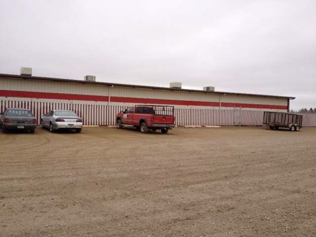
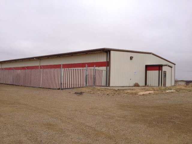
1200 Northstar Dr
Bismarck, ND
North Star Commercial Park Iii
31-139-80-68-01-040
TWN: 139 RNG: 80 SUB: 311398068 BLK: 01 NORTHSTAR COMM PARK 3RD BLOCK 01 LOT 4 804413 804414
Recyclingfacility
Burleigh
X
North Dakota
38015C0595E
4-80441
2024
2.33 AC
2024
North Bismarck
011001
Other Market Areas
14,000 SF
DEMOGRAPHICS near 1200 Northstar Dr
1 Mile
3 Mile
5 Mile
2024 Total Population
536
22,670
62,697
2029 Population
560
23,412
64,661
Pop Growth 2024-2029
+ 4.48%
+ 3.27%
+ 3.13%
Average Age
38
41
41
2024 Total Households
191
8,954
25,933
HH Growth 2024-2029
+ 4.19%
+ 3.32%
+ 3.15%
Median Household Inc
$110,546
$87,488
$72,183
Avg Household Size
2.70
2.40
2.30
2024 Avg HH Vehicles
2.00
2.00
2.00
Median Home Value
$363,333
$344,310
$283,890
Median Year Built
2010
2007
1990
Nearby Places
Map Layers
Map Styles
 Street
 Aerial
- Restaurants
- Banks
- Shops
- Fitness
- Groceries
PUBLIC TRANSPORTATION
AIRPORT
Bismarck Municipal
DRIVE
WALK
Distance
Bismarck Municipal
23 min
9.6 mi
Freight Ports
Port Milwaukee
DRIVE
WALK
Distance
Port Milwaukee
826 min
766.7 mi
Nearby Properties
Address
Land Use
TOTAL SIZE
Lot Size
Zoning
Address
Land Use
TOTAL SIZE
Lot Size
Zoning
76,233 SF
14.71 AC
RM20
Address
Land Use
TOTAL SIZE
Lot Size
Zoning
28.06 AC
CG
Address
Land Use
TOTAL SIZE
Lot Size
Zoning
18.70 AC
RM15
Address
Land Use
TOTAL SIZE
Lot Size
Zoning
27.48 AC
CG
Address
Land Use
TOTAL SIZE
Lot Size
Zoning
7.67 AC
CG
Address
Land Use
TOTAL SIZE
Lot Size
Zoning
31,202 SF
9.05 AC
RM30
Address
Land Use
TOTAL SIZE
Lot Size
Zoning
20.87 AC
CG
Address
Land Use
TOTAL SIZE
Lot Size
Zoning
65,001 SF
9.88 AC
RT
Address
Land Use
TOTAL SIZE
Lot Size
Zoning
16.12 AC
CG
Address
Land Use
TOTAL SIZE
Lot Size
Zoning
38,275 SF
10.53 AC
RM30
Address
Land Use
TOTAL SIZE
Lot Size
Zoning
39,771 SF
9.65 AC
CG
Address
Land Use
TOTAL SIZE
Lot Size
Zoning
27,639 SF
4.28 AC
RT
Address
Land Use
TOTAL SIZE
Lot Size
Zoning
7.83 AC
RM20
Address
Land Use
TOTAL SIZE
Lot Size
Zoning
52,710 SF
7.13 AC
RM30
Address
Land Use
TOTAL SIZE
Lot Size
Zoning
52,718 SF
2.67 AC
RM15
Address
Land Use
TOTAL SIZE
Lot Size
Zoning
74,564 SF
6.67 AC
RT
Address
Land Use
TOTAL SIZE
Lot Size
Zoning
8,685 SF
12.51 AC
CG
Address
Land Use
TOTAL SIZE
Lot Size
Zoning
40,647 SF
2.67 AC
PUD
Address
Land Use
TOTAL SIZE
Lot Size
Zoning
25,831 SF
17.10 AC
CG
Address
Land Use
TOTAL SIZE
Lot Size
Zoning
3.90 AC
RM30
Address
Land Use
TOTAL SIZE
Lot Size
Zoning
74,250 SF
5.63 AC
PUD
Address
Land Use
TOTAL SIZE
Lot Size
Zoning
25.59 AC
CG
Address
Land Use
TOTAL SIZE
Lot Size
Zoning
7,560 SF
4.39 AC
PUD
Address
Land Use
TOTAL SIZE
Lot Size
Zoning
6.86 AC
CG
Address
Land Use
TOTAL SIZE
Lot Size
Zoning
4.18 AC
RT
Address
Land Use
TOTAL SIZE
Lot Size
Zoning
27,639 SF
4.28 AC
RT
Address
Land Use
TOTAL SIZE
Lot Size
Zoning
44,694 SF
5.76 AC
RM30
Address
Land Use
TOTAL SIZE
Lot Size
Zoning
60,510 SF
7.48 AC
CG
Address
Land Use
TOTAL SIZE
Lot Size
Zoning
40,280 SF
4.17 AC
CG
Address
Land Use
TOTAL SIZE
Lot Size
Zoning
5,658 SF
7.28 AC
CG
The World's #1 Commercial Real Estate Marketplace
Connect with us
© 2025 CoStar Group
The information above has been obtained from sources believed reliable. While we do not doubt its accuracy we have not verified it and make no guarantee, warranty or representation about it. It is your responsibility to independently confirm its accuracy and completeness. Any projections, opinions, assumptions, or estimates used are for example only and do not represent the current or future performance of the property. The value of this transaction to you depends on tax and other factors which should be evaluated by your tax, financial, and legal advisors. You and your advisors should conduct a careful, independent investigation of the property to determine to your satisfaction the suitability of the property for your needs.