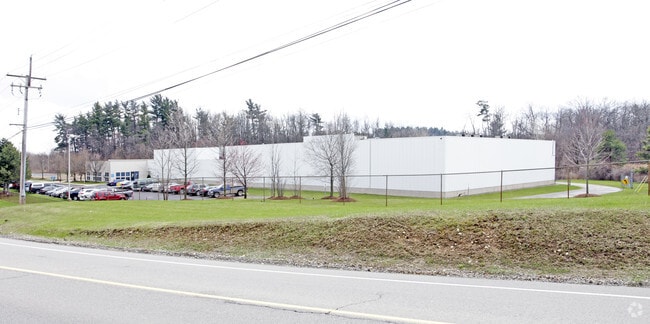
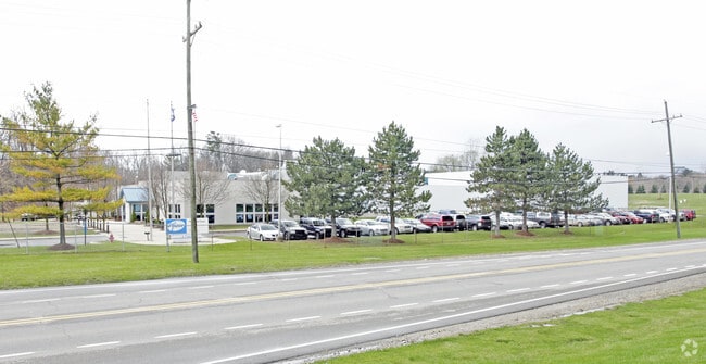
Property Record
1200 Parkdale Rd, Rochester, MI 48307


NEARBY LISTINGS FOR SALE OR LEASE
Property Detail
1200 Parkdale Rd
15-12-351-006
T3N, R11E, SEC 12 PART OF SW 1/4 BEG AT PT DIST S 00-35-54 E 824.08 FT & N 76-23-36 E 755.69 FT & N 68-40-46 E 1206.78 FT & N
Warehouse
Oakland
X
Michigan
26099C0211G
21.60 AC
2024
Auburn Hills, Pontiac & Rochester
2025
Detroit
191200
Detroit-Warren-Dearborn, MI
69,871 SF
DEMOGRAPHICS near 1200 Parkdale Rd
1 Mile
3 Mile
5 Mile
2024 Total Population
8,491
64,001
153,560
2029 Population
8,411
63,473
152,200
Pop Growth 2024-2029
(0.94%)
(0.82%)
(0.89%)
Average Age
42
42
42
2024 Total Households
3,474
26,173
61,113
HH Growth 2024-2029
(0.95%)
(0.75%)
(0.86%)
Median Household Inc
$116,246
$99,058
$99,412
Avg Household Size
2.40
2.40
2.50
2024 Avg HH Vehicles
2.00
2.00
2.00
Median Home Value
$436,103
$358,414
$352,754
Median Year Built
1991
1982
1983
Nearby Places
Map Layers
Map Styles
 Street
 Aerial
- Restaurants
- Banks
- Shops
- Fitness
- Groceries
PUBLIC TRANSPORTATION
AIRPORT
Windsor International
DRIVE
WALK
Distance
Windsor International
64 min
37.5 mi
Nearby Properties
Address
Land Use
TOTAL SIZE
Lot Size
Zoning
Address
Land Use
TOTAL SIZE
Lot Size
Zoning
444,087 SF
83.19 AC
II
Address
Land Use
TOTAL SIZE
Lot Size
Zoning
3,529 SF
29.19 AC
BI
Address
Land Use
TOTAL SIZE
Lot Size
Zoning
57.84 AC
AV
Address
Land Use
TOTAL SIZE
Lot Size
Zoning
389,465 SF
30.24 AC
II
Address
Land Use
TOTAL SIZE
Lot Size
Zoning
Address
Land Use
TOTAL SIZE
Lot Size
Zoning
195,413 SF
4.43 AC
Address
Land Use
TOTAL SIZE
Lot Size
Zoning
35.60 AC
R-12
Address
Land Use
TOTAL SIZE
Lot Size
Zoning
257,878 SF
30 AC
Address
Land Use
TOTAL SIZE
Lot Size
Zoning
22.09 AC
AI
Address
Land Use
TOTAL SIZE
Lot Size
Zoning
134,904 SF
5 AC
Address
Land Use
TOTAL SIZE
Lot Size
Zoning
29,394 SF
33.83 AC
CK MAP
Address
Land Use
TOTAL SIZE
Lot Size
Zoning
19.47 AC
R-8
Address
Land Use
TOTAL SIZE
Lot Size
Zoning
119.30 AC
Address
Land Use
TOTAL SIZE
Lot Size
Zoning
21.52 AC
AI
Address
Land Use
TOTAL SIZE
Lot Size
Zoning
Address
Land Use
TOTAL SIZE
Lot Size
Zoning
10.28 AC
CK MAP
Address
Land Use
TOTAL SIZE
Lot Size
Zoning
9.47 AC
R-9
Address
Land Use
TOTAL SIZE
Lot Size
Zoning
51.98 AC
MHP
Address
Land Use
TOTAL SIZE
Lot Size
Zoning
62,495 SF
2.49 AC
MM
Address
Land Use
TOTAL SIZE
Lot Size
Zoning
89,450 SF
0.41 AC
BI
Address
Land Use
TOTAL SIZE
Lot Size
Zoning
26.25 AC
AI
Address
Land Use
TOTAL SIZE
Lot Size
Zoning
96,460 SF
17.50 AC
Address
Land Use
TOTAL SIZE
Lot Size
Zoning
55,651 SF
23.39 AC
II
Address
Land Use
TOTAL SIZE
Lot Size
Zoning
191.40 AC
AI
Address
Land Use
TOTAL SIZE
Lot Size
Zoning
112,300 SF
25.04 AC
The World's #1 Commercial Real Estate Marketplace
Connect with us
© 2026 CoStar Group
The information above has been obtained from sources believed reliable. While we do not doubt its accuracy we have not verified it and make no guarantee, warranty or representation about it. It is your responsibility to independently confirm its accuracy and completeness. Any projections, opinions, assumptions, or estimates used are for example only and do not represent the current or future performance of the property. The value of this transaction to you depends on tax and other factors which should be evaluated by your tax, financial, and legal advisors. You and your advisors should conduct a careful, independent investigation of the property to determine to your satisfaction the suitability of the property for your needs.