Property Record
1200 Simpson Rd, Kissimmee, FL 34744


NEARBY LISTINGS FOR SALE OR LEASE
Property Detail
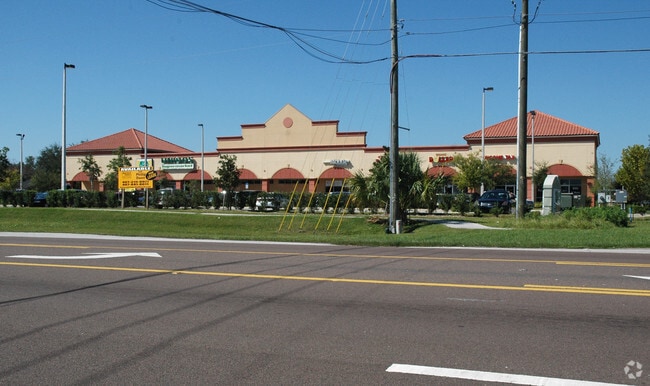
1200 Simpson Rd
Orlando-Kissimmee-Sanford, FL
Owen Replat
19-25-30-1879-0001-0030
OWEN SUBBDIVISION REPLAT PB 17 PG 173 LOT 3 LESS BEG AT NE COR OF LOT 3, S00-21-32E 200.09 FT, N06-44-22W 108.83 FT TO POC, CONC E, RAD 1002 FT, CENT ANG 01 DEG, (CH BEARING N06-02-21W 24.50 FT), NLY ALONG CURVE 24.50 FT, N84-39-41E 1 FT TO NON-TAN C
Storebuilding
Osceola
X
Florida
12095C0650G
3
2024
1.73 AC
2025
Osceola Outlying
042905
Orlando
17,600 SF
DEMOGRAPHICS near 1200 Simpson Rd
1 Mile
3 Mile
5 Mile
2024 Total Population
10,822
73,079
176,608
2029 Population
12,790
86,888
204,606
Pop Growth 2024-2029
+ 18.19%
+ 18.90%
+ 15.85%
Average Age
39
38
38
2024 Total Households
3,370
23,545
57,818
HH Growth 2024-2029
+ 17.92%
+ 18.81%
+ 15.97%
Median Household Inc
$50,577
$55,453
$55,373
Avg Household Size
3.00
3.00
3.00
2024 Avg HH Vehicles
2.00
2.00
2.00
Median Home Value
$238,771
$255,896
$266,911
Median Year Built
1995
1995
1997
Nearby Places
Map Layers
Map Styles
 Street
 Aerial
- Restaurants
- Banks
- Shops
- Fitness
- Groceries
PUBLIC TRANSPORTATION
COMMUTER RAIL
Kissimmee Amtrak Station (Silver Meteor - Amtrak, Silver Star - Amtrak, SunRail - Amtrak)
DRIVE
WALK
Distance
Kissimmee Amtrak Station (Silver Meteor - Amtrak, Silver Star - Amtrak, SunRail - Amtrak)
9 min
4.4 mi
Tupperware (SunRail - Florida Department of Transportation)
DRIVE
WALK
Distance
Tupperware (SunRail - Florida Department of Transportation)
12 min
5.6 mi
AIRPORT
Orlando International
DRIVE
WALK
Distance
Orlando International
19 min
11.7 mi
Freight Ports
Port Canaveral
DRIVE
WALK
Distance
Port Canaveral
67 min
53.4 mi
Nearby Properties
Address
Land Use
TOTAL SIZE
Lot Size
Zoning
Address
Land Use
TOTAL SIZE
Lot Size
Zoning
457,374 SF
30.93 AC
OCT
Address
Land Use
TOTAL SIZE
Lot Size
Zoning
402,010 SF
22.33 AC
OCR
Address
Land Use
TOTAL SIZE
Lot Size
Zoning
334,569 SF
11.82 AC
Address
Land Use
TOTAL SIZE
Lot Size
Zoning
416,762 SF
99.87 AC
KCF
Address
Land Use
TOTAL SIZE
Lot Size
Zoning
343,107 SF
16.26 AC
OEC
Address
Land Use
TOTAL SIZE
Lot Size
Zoning
379,943 SF
14.07 AC
OCT
Address
Land Use
TOTAL SIZE
Lot Size
Zoning
142,570 SF
20.16 AC
OPD
Address
Land Use
TOTAL SIZE
Lot Size
Zoning
351,537 SF
44.58 AC
OPD
Address
Land Use
TOTAL SIZE
Lot Size
Zoning
437,037 SF
34.76 AC
OPUD
Address
Land Use
TOTAL SIZE
Lot Size
Zoning
188,719 SF
10.81 AC
Address
Land Use
TOTAL SIZE
Lot Size
Zoning
203,711 SF
10.27 AC
Address
Land Use
TOTAL SIZE
Lot Size
Zoning
374,081 SF
36.66 AC
KRC1
Address
Land Use
TOTAL SIZE
Lot Size
Zoning
187,302 SF
20.85 AC
Address
Land Use
TOTAL SIZE
Lot Size
Zoning
152,370 SF
14.05 AC
OCR
Address
Land Use
TOTAL SIZE
Lot Size
Zoning
343,593 SF
49.46 AC
OAC
Address
Land Use
TOTAL SIZE
Lot Size
Zoning
145,028 SF
6.85 AC
Address
Land Use
TOTAL SIZE
Lot Size
Zoning
57,939 SF
80.04 AC
OPD
Address
Land Use
TOTAL SIZE
Lot Size
Zoning
309,075 SF
16.94 AC
OPUD
Address
Land Use
TOTAL SIZE
Lot Size
Zoning
304,494 SF
15.67 AC
Address
Land Use
TOTAL SIZE
Lot Size
Zoning
258,588 SF
119.70 AC
OAC
Address
Land Use
TOTAL SIZE
Lot Size
Zoning
73,910 SF
4.61 AC
OCT
Address
Land Use
TOTAL SIZE
Lot Size
Zoning
113,079 SF
8.96 AC
OCT
Address
Land Use
TOTAL SIZE
Lot Size
Zoning
170,800 SF
44.94 AC
KCF
Address
Land Use
TOTAL SIZE
Lot Size
Zoning
105,918 SF
13.34 AC
KHC
Address
Land Use
TOTAL SIZE
Lot Size
Zoning
63,524 SF
10.88 AC
OCR
Address
Land Use
TOTAL SIZE
Lot Size
Zoning
42,528 SF
17 AC
ORM3
Address
Land Use
TOTAL SIZE
Lot Size
Zoning
113,362 SF
40.78 AC
OPUD
Address
Land Use
TOTAL SIZE
Lot Size
Zoning
66,171 SF
8.42 AC
OCR
Address
Land Use
TOTAL SIZE
Lot Size
Zoning
91,320 SF
1.90 AC
OCR
Address
Land Use
TOTAL SIZE
Lot Size
Zoning
107,790 SF
4.09 AC
OAC
The World's #1 Commercial Real Estate Marketplace
Connect with us
© 2026 CoStar Group
The information above has been obtained from sources believed reliable. While we do not doubt its accuracy we have not verified it and make no guarantee, warranty or representation about it. It is your responsibility to independently confirm its accuracy and completeness. Any projections, opinions, assumptions, or estimates used are for example only and do not represent the current or future performance of the property. The value of this transaction to you depends on tax and other factors which should be evaluated by your tax, financial, and legal advisors. You and your advisors should conduct a careful, independent investigation of the property to determine to your satisfaction the suitability of the property for your needs.