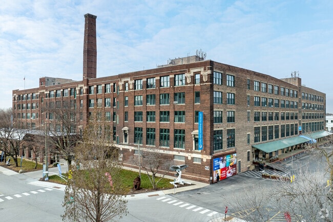
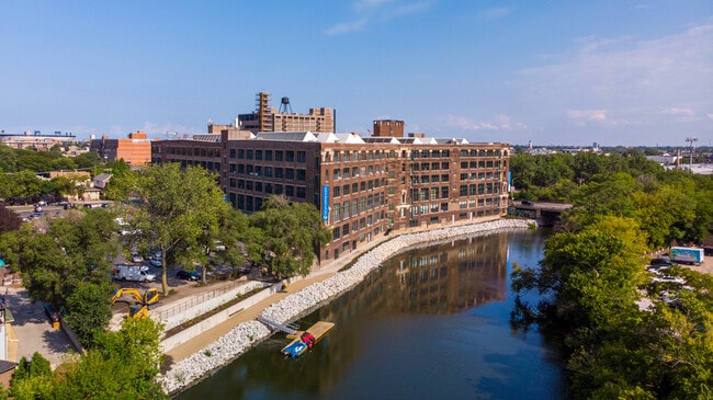
Property Record
1200 W 35Th St, Chicago, IL 60609

Current Lease Availabilities
NEARBY LISTINGS FOR SALE OR LEASE
Property Detail
1200 W 35Th St
17-32-116-008-0000
T C Hammonds Sub Of Lt 34 Of Assessors
Commercialnec
Cook
A
Illinois
17031C0508J
4
2023
2.62 AC
2024
South Chicago
839700
Chicago
460,333 SF
Chicago-Naperville-Elgin, IL-IN-WI
DEMOGRAPHICS near 1200 W 35Th St
1 Mile
3 Mile
5 Mile
2024 Total Population
29,235
290,536
843,582
2029 Population
27,111
272,936
806,555
Pop Growth 2024-2029
(7.27%)
(6.06%)
(4.39%)
Average Age
39
37
37
2024 Total Households
11,161
112,413
355,438
HH Growth 2024-2029
(7.76%)
(5.89%)
(3.91%)
Median Household Inc
$68,402
$53,417
$64,540
Avg Household Size
2.50
2.40
2.20
2024 Avg HH Vehicles
1.00
1.00
1.00
Median Home Value
$351,991
$305,362
$320,294
Median Year Built
1947
1954
1963
Nearby Places
Map Layers
Map Styles
 Street
 Aerial
- Restaurants
- Banks
- Shops
- Fitness
- Groceries
PUBLIC TRANSPORTATION
TRANSIT/SUBWAY
Ashland Station (Orange Line) (Orange Line - Chicago Transit Authority "L" Trains (The "L"))
DRIVE
WALK
Distance
Ashland Station (Orange Line) (Orange Line - Chicago Transit Authority "L" Trains (The "L"))
3 min
20 min
1.1 mi
COMMUTER RAIL
35Th St. - Lou Jones (Rock Island - Metra)
DRIVE
WALK
Distance
35Th St. - Lou Jones (Rock Island - Metra)
3 min
1.5 mi
Halsted Station (Burlington Northern-Santa Fe Railway Line - Northeast Illinois Regional Commuter Railroad (Metra))
DRIVE
WALK
Distance
Halsted Station (Burlington Northern-Santa Fe Railway Line - Northeast Illinois Regional Commuter Railroad (Metra))
6 min
2.7 mi
AIRPORT
Chicago Midway International
DRIVE
WALK
Distance
Chicago Midway International
12 min
6.3 mi
Chicago O'Hare International
DRIVE
WALK
Distance
Chicago O'Hare International
34 min
21.1 mi
Freight Ports
Port Milwaukee
DRIVE
WALK
Distance
Port Milwaukee
112 min
89.3 mi
Nearby Properties
Address
Land Use
TOTAL SIZE
Lot Size
Zoning
Address
Land Use
TOTAL SIZE
Lot Size
Zoning
1,215,367 SF
3.76 AC
PD 675
Address
Land Use
TOTAL SIZE
Lot Size
Zoning
1.44 AC
PD 30
Address
Land Use
TOTAL SIZE
Lot Size
Zoning
474,979 SF
29.67 AC
PD 553
Address
Land Use
TOTAL SIZE
Lot Size
Zoning
979,674 SF
6.01 AC
PD 924
Address
Land Use
TOTAL SIZE
Lot Size
Zoning
662,088 SF
4.91 AC
PD 504
Address
Land Use
TOTAL SIZE
Lot Size
Zoning
590,844 SF
0.80 AC
PD 26
Address
Land Use
TOTAL SIZE
Lot Size
Zoning
408,203 SF
2.02 AC
DS-5
Address
Land Use
TOTAL SIZE
Lot Size
Zoning
0.85 AC
DS-3
Address
Land Use
TOTAL SIZE
Lot Size
Zoning
325,558 SF
Address
Land Use
TOTAL SIZE
Lot Size
Zoning
4.11 AC
M2-3
Address
Land Use
TOTAL SIZE
Lot Size
Zoning
611,160 SF
2.36 AC
PD 523
Address
Land Use
TOTAL SIZE
Lot Size
Zoning
134,800 SF
2.53 AC
PD 1273
Address
Land Use
TOTAL SIZE
Lot Size
Zoning
0.35 AC
PD 1317
Address
Land Use
TOTAL SIZE
Lot Size
Zoning
548,210 SF
1.11 AC
PD 681
Address
Land Use
TOTAL SIZE
Lot Size
Zoning
508,816 SF
1.11 AC
DX-7,PD 49
Address
Land Use
TOTAL SIZE
Lot Size
Zoning
111,322 SF
1 AC
DS-5
Address
Land Use
TOTAL SIZE
Lot Size
Zoning
1.82 AC
PD 30
Address
Land Use
TOTAL SIZE
Lot Size
Zoning
1,000 SF
0.33 AC
PD 1326
Address
Land Use
TOTAL SIZE
Lot Size
Zoning
250,040 SF
15.70 AC
PD 1169
Address
Land Use
TOTAL SIZE
Lot Size
Zoning
542,503 SF
7.78 AC
PD 523
Address
Land Use
TOTAL SIZE
Lot Size
Zoning
13.54 AC
Address
Land Use
TOTAL SIZE
Lot Size
Zoning
136,720 SF
0.54 AC
PD 1
Address
Land Use
TOTAL SIZE
Lot Size
Zoning
121,250 SF
0.84 AC
PD 30
Address
Land Use
TOTAL SIZE
Lot Size
Zoning
225,784 SF
0.69 AC
DS-3
Address
Land Use
TOTAL SIZE
Lot Size
Zoning
264,800 SF
0.61 AC
DX-7
Address
Land Use
TOTAL SIZE
Lot Size
Zoning
169,435 SF
11.35 AC
PD 307
Address
Land Use
TOTAL SIZE
Lot Size
Zoning
103,442 SF
1.43 AC
DS-5
Address
Land Use
TOTAL SIZE
Lot Size
Zoning
313,559 SF
PD 1318
Address
Land Use
TOTAL SIZE
Lot Size
Zoning
630,837 SF
0.25 AC
PD 1317
Address
Land Use
TOTAL SIZE
Lot Size
Zoning
307,277 SF
9.90 AC
PMD 11
The World's #1 Commercial Real Estate Marketplace
Connect with us
© 2025 CoStar Group
The information above has been obtained from sources believed reliable. While we do not doubt its accuracy we have not verified it and make no guarantee, warranty or representation about it. It is your responsibility to independently confirm its accuracy and completeness. Any projections, opinions, assumptions, or estimates used are for example only and do not represent the current or future performance of the property. The value of this transaction to you depends on tax and other factors which should be evaluated by your tax, financial, and legal advisors. You and your advisors should conduct a careful, independent investigation of the property to determine to your satisfaction the suitability of the property for your needs.