Property Record
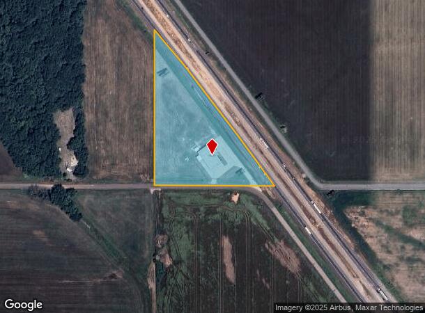
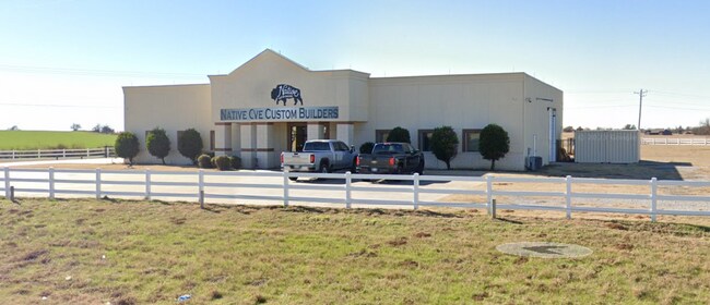
1200 W Interstate Dr, Norman, OK 73072

NEARBY LISTINGS FOR SALE OR LEASE
Property Detail
1200 W Interstate Dr
00001408N03W002800
333 Purcell
Warehouse
BEG AT SW/C OF SW SE E 479.03 TO HWY ROW TH NW 792.17 THEN S 632.4 TO POB LEGAL 2254/676
X
Mcclain
40027C0290H
Oklahoma
2024
3.50 AC
2025
Southwest Outlying
400204
Oklahoma City
6,380 SF
Oklahoma City, OK
DEMOGRAPHICS near 1200 W Interstate Dr
1 Mile
3 Mile
5 Mile
2024 Total Population
838
10,870
74,227
2029 Population
1,010
11,888
78,213
Pop Growth 2024-2029
+ 20.53%
+ 9.37%
+ 5.37%
Average Age
40
40
35
2024 Total Households
281
4,604
29,112
HH Growth 2024-2029
+ 20.64%
+ 8.58%
+ 5.61%
Median Household Inc
$93,181
$58,348
$50,295
Avg Household Size
2.90
2.30
2.20
2024 Avg HH Vehicles
3.00
2.00
2.00
Median Home Value
$312,000
$265,144
$228,528
Median Year Built
2000
1985
1984
Nearby Places
Map Layers
Map Styles
 Street
 Aerial
- Restaurants
- Banks
- Shops
- Fitness
- Groceries
PUBLIC TRANSPORTATION
COMMUTER RAIL
Norman Amtrak Station (Heartland Flyer - Amtrak)
DRIVE
WALK
Distance
Norman Amtrak Station (Heartland Flyer - Amtrak)
16 min
8.8 mi
AIRPORT
Will Rogers World
DRIVE
WALK
Distance
Will Rogers World
41 min
26.8 mi
Freight Ports
Tulsa Port Of Catoosa
DRIVE
WALK
Distance
Tulsa Port Of Catoosa
162 min
146.0 mi
SALE & LEASE HISTORY
LISTING DATE
SALE/LEASE

Apr 30, 2021
For Lease
Nearby Properties
Address
Land Use
TOTAL SIZE
Lot Size
Zoning
Address
Land Use
TOTAL SIZE
Lot Size
Zoning
Address
Land Use
TOTAL SIZE
Lot Size
Zoning
Address
Land Use
TOTAL SIZE
Lot Size
Zoning
Address
Land Use
TOTAL SIZE
Lot Size
Zoning
65,350 SF
8.79 AC
Address
Land Use
TOTAL SIZE
Lot Size
Zoning
168,028 SF
8.14 AC
RM
Address
Land Use
TOTAL SIZE
Lot Size
Zoning
Address
Land Use
TOTAL SIZE
Lot Size
Zoning
1,568 SF
5.48 AC
Address
Land Use
TOTAL SIZE
Lot Size
Zoning
109,851 SF
5.30 AC
C2
Address
Land Use
TOTAL SIZE
Lot Size
Zoning
7.59 AC
Address
Land Use
TOTAL SIZE
Lot Size
Zoning
135,487 SF
4.85 AC
Address
Land Use
TOTAL SIZE
Lot Size
Zoning
78,932 SF
3.98 AC
RM
Address
Land Use
TOTAL SIZE
Lot Size
Zoning
5,700 SF
0.61 AC
Address
Land Use
TOTAL SIZE
Lot Size
Zoning
27,102 SF
1.54 AC
Address
Land Use
TOTAL SIZE
Lot Size
Zoning
36,735 SF
3.87 AC
Address
Land Use
TOTAL SIZE
Lot Size
Zoning
506 SF
5.23 AC
RM
Address
Land Use
TOTAL SIZE
Lot Size
Zoning
33,426 SF
4.87 AC
Address
Land Use
TOTAL SIZE
Lot Size
Zoning
58,191 SF
2.73 AC
C2
Address
Land Use
TOTAL SIZE
Lot Size
Zoning
33,046 SF
2.16 AC
C2
Address
Land Use
TOTAL SIZE
Lot Size
Zoning
65,855 SF
3.61 AC
RM
Address
Land Use
TOTAL SIZE
Lot Size
Zoning
24,219 SF
1.27 AC
C2
Address
Land Use
TOTAL SIZE
Lot Size
Zoning
47,632 SF
4.55 AC
Address
Land Use
TOTAL SIZE
Lot Size
Zoning
53,060 SF
4.86 AC
Address
Land Use
TOTAL SIZE
Lot Size
Zoning
8.66 AC
Address
Land Use
TOTAL SIZE
Lot Size
Zoning
4.26 AC
Address
Land Use
TOTAL SIZE
Lot Size
Zoning
1,443 SF
2.60 AC
Address
Land Use
TOTAL SIZE
Lot Size
Zoning
26,144 SF
3.12 AC
The World's #1 Commercial Real Estate Marketplace
Connect with us
© 2025 CoStar Group
The information above has been obtained from sources believed reliable. While we do not doubt its accuracy we have not verified it and make no guarantee, warranty or representation about it. It is your responsibility to independently confirm its accuracy and completeness. Any projections, opinions, assumptions, or estimates used are for example only and do not represent the current or future performance of the property. The value of this transaction to you depends on tax and other factors which should be evaluated by your tax, financial, and legal advisors. You and your advisors should conduct a careful, independent investigation of the property to determine to your satisfaction the suitability of the property for your needs.