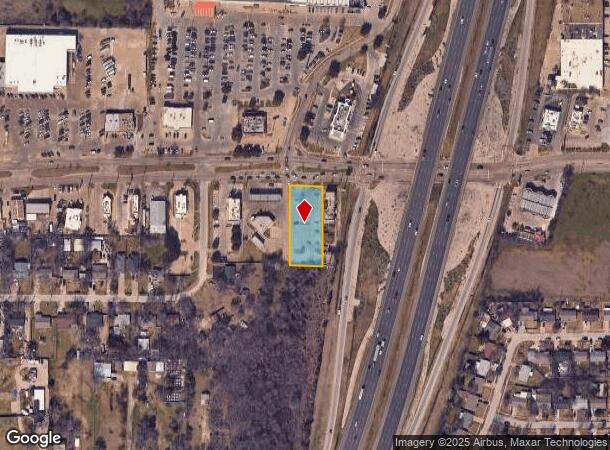
Property Record
12008 Elam Rd, Balch Springs, TX 75180

NEARBY LISTINGS FOR SALE OR LEASE
Property Detail
12008 Elam Rd
Dallas-Fort Worth-Arlington, TX
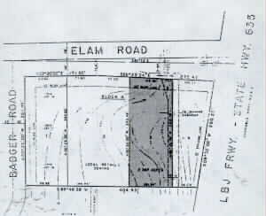
Terup
120820000A0030000
TERUP BLK A LOT 3 INT202200243361 DD08312022 CO-DC 0820000A00300 3CB0820000A
Commercialacreage
Dallas
X
Texas
48257C0150E
3
2024
0.62 AC
2025
Pleasant Gr/SE Dallas
017201
Dallas/Ft Worth
DEMOGRAPHICS near 12008 Elam Rd
1 Mile
3 Mile
5 Mile
2024 Total Population
14,125
92,419
237,306
2029 Population
14,229
91,833
234,726
Pop Growth 2024-2029
+ 0.74%
(0.63%)
(1.09%)
Average Age
33
34
34
2024 Total Households
4,232
26,463
68,721
HH Growth 2024-2029
+ 0.54%
(0.84%)
(1.39%)
Median Household Inc
$51,998
$53,760
$53,263
Avg Household Size
3.20
3.40
3.30
2024 Avg HH Vehicles
2.00
2.00
2.00
Median Home Value
$195,711
$170,262
$168,465
Median Year Built
1983
1982
1981
Nearby Places
Map Layers
Map Styles
 Street
 Aerial
- Restaurants
- Banks
- Shops
- Fitness
- Groceries
PUBLIC TRANSPORTATION
AIRPORT
Dallas Love Field
DRIVE
WALK
Distance
Dallas Love Field
30 min
20.1 mi
Dallas-Fort Worth International
DRIVE
WALK
Distance
Dallas-Fort Worth International
45 min
36.0 mi
Freight Ports
Port of Shreveport
DRIVE
WALK
Distance
Port of Shreveport
199 min
185.3 mi
Nearby Properties
Address
Land Use
TOTAL SIZE
Lot Size
Zoning
Address
Land Use
TOTAL SIZE
Lot Size
Zoning
263,360 SF
42.98 AC
Z237
Address
Land Use
TOTAL SIZE
Lot Size
Zoning
199,246 SF
15.32 AC
Z250
Address
Land Use
TOTAL SIZE
Lot Size
Zoning
257,745 SF
31.54 AC
Z298
Address
Land Use
TOTAL SIZE
Lot Size
Zoning
200,000 SF
8.11 AC
Address
Land Use
TOTAL SIZE
Lot Size
Zoning
255,008 SF
30.39 AC
Z250
Address
Land Use
TOTAL SIZE
Lot Size
Zoning
290,916 SF
8.24 AC
Address
Land Use
TOTAL SIZE
Lot Size
Zoning
257,696 SF
9.62 AC
Address
Land Use
TOTAL SIZE
Lot Size
Zoning
214,853 SF
6.60 AC
Z372
Address
Land Use
TOTAL SIZE
Lot Size
Zoning
364,000 SF
40.25 AC
Z236
Address
Land Use
TOTAL SIZE
Lot Size
Zoning
298,150 SF
20.01 AC
Z14
Address
Land Use
TOTAL SIZE
Lot Size
Zoning
267,011 SF
11.11 AC
Z250
Address
Land Use
TOTAL SIZE
Lot Size
Zoning
141,566 SF
23 AC
Z298
Address
Land Use
TOTAL SIZE
Lot Size
Zoning
86,875 SF
6.57 AC
Z376
Address
Land Use
TOTAL SIZE
Lot Size
Zoning
166,846 SF
6.78 AC
Z59
Address
Land Use
TOTAL SIZE
Lot Size
Zoning
64,404 SF
19.79 AC
Z250
Address
Land Use
TOTAL SIZE
Lot Size
Zoning
238,728 SF
12.31 AC
Z184
Address
Land Use
TOTAL SIZE
Lot Size
Zoning
234,459 SF
9.71 AC
Z138
Address
Land Use
TOTAL SIZE
Lot Size
Zoning
123,499 SF
8.32 AC
Z239
Address
Land Use
TOTAL SIZE
Lot Size
Zoning
91,871 SF
8.44 AC
Z05
Address
Land Use
TOTAL SIZE
Lot Size
Zoning
190,150 SF
13.39 AC
Z236
Address
Land Use
TOTAL SIZE
Lot Size
Zoning
215 SF
29.95 AC
A
Address
Land Use
TOTAL SIZE
Lot Size
Zoning
118,237 SF
5.56 AC
Z183
Address
Land Use
TOTAL SIZE
Lot Size
Zoning
92,104 SF
8.13 AC
Z372
Address
Land Use
TOTAL SIZE
Lot Size
Zoning
123,790 SF
6.68 AC
Z183
Address
Land Use
TOTAL SIZE
Lot Size
Zoning
143,713 SF
9.29 AC
Z59
Address
Land Use
TOTAL SIZE
Lot Size
Zoning
248 SF
32.79 AC
MFA
Address
Land Use
TOTAL SIZE
Lot Size
Zoning
160,000 SF
9.60 AC
Z250
Address
Land Use
TOTAL SIZE
Lot Size
Zoning
183 SF
23.14 AC
Z06
Address
Land Use
TOTAL SIZE
Lot Size
Zoning
70,000 SF
25.26 AC
Z06
Address
Land Use
TOTAL SIZE
Lot Size
Zoning
143,880 SF
43.64 AC
Z35
The World's #1 Commercial Real Estate Marketplace
Connect with us
© 2025 CoStar Group
The information above has been obtained from sources believed reliable. While we do not doubt its accuracy we have not verified it and make no guarantee, warranty or representation about it. It is your responsibility to independently confirm its accuracy and completeness. Any projections, opinions, assumptions, or estimates used are for example only and do not represent the current or future performance of the property. The value of this transaction to you depends on tax and other factors which should be evaluated by your tax, financial, and legal advisors. You and your advisors should conduct a careful, independent investigation of the property to determine to your satisfaction the suitability of the property for your needs.