Property Record
12009 Foundation Pl, Gold River, CA 95670
Current Lease Availabilities
NEARBY LISTINGS FOR SALE OR LEASE
Property Detail
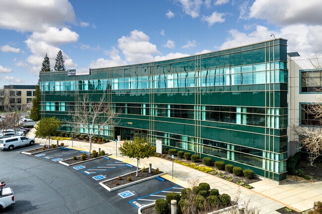
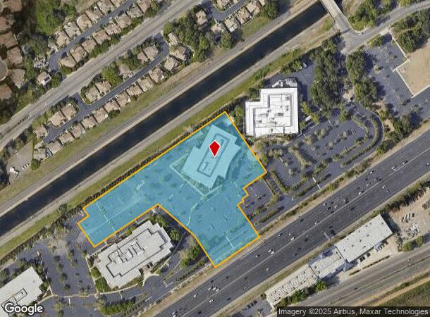
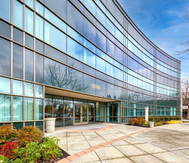
12009 Foundation Pl
Sacramento--Roseville--Arden-Arcade, CA
Gold Point Office Park
069-0260-017
GOLD POINT OFFICE PARK, LOT 4
Officebuilding
Sacramento
X
California
06067C0113H
4
2024
5.79 AC
2025
Highway 50 Corridor
008703
Sacramento
110,000 SF
DEMOGRAPHICS near 12009 Foundation Pl
1 Mile
3 Mile
5 Mile
2024 Total Population
3,537
42,830
181,328
2029 Population
3,530
43,030
182,619
Pop Growth 2024-2029
(0.20%)
+ 0.47%
+ 0.71%
Average Age
47
46
42
2024 Total Households
1,614
18,002
71,284
HH Growth 2024-2029
(0.19%)
+ 0.46%
+ 0.69%
Median Household Inc
$121,505
$107,391
$94,173
Avg Household Size
2.10
2.30
2.50
2024 Avg HH Vehicles
2.00
2.00
2.00
Median Home Value
$695,473
$639,583
$541,049
Median Year Built
1988
1981
1979
Nearby Places
Map Layers
Map Styles
 Street
 Aerial
- Restaurants
- Banks
- Shops
- Fitness
- Groceries
PUBLIC TRANSPORTATION
TRANSIT/SUBWAY
Hazel (Gold Line - Sacramento Regional Transit District Light Rail (The RT))
DRIVE
WALK
Distance
Hazel (Gold Line - Sacramento Regional Transit District Light Rail (The RT))
3 min
20 min
1.1 mi
AIRPORT
Sacramento International
DRIVE
WALK
Distance
Sacramento International
40 min
30.3 mi
Freight Ports
Port of Stockton
DRIVE
WALK
Distance
Port of Stockton
76 min
63.9 mi
Nearby Properties
Address
Land Use
TOTAL SIZE
Lot Size
Zoning
Address
Land Use
TOTAL SIZE
Lot Size
Zoning
SPA (ASPA)
Address
Land Use
TOTAL SIZE
Lot Size
Zoning
304,607 SF
14.70 AC
LC
Address
Land Use
TOTAL SIZE
Lot Size
Zoning
287,131 SF
32.53 AC
C-3 (PD)
Address
Land Use
TOTAL SIZE
Lot Size
Zoning
7.94 AC
RD-25
Address
Land Use
TOTAL SIZE
Lot Size
Zoning
202,776 SF
12.17 AC
RD-25 (PC)
Address
Land Use
TOTAL SIZE
Lot Size
Zoning
269,928 SF
246.95 AC
SPA
Address
Land Use
TOTAL SIZE
Lot Size
Zoning
2,146.73 AC
SPA
Address
Land Use
TOTAL SIZE
Lot Size
Zoning
241,672 SF
18.54 AC
SC
Address
Land Use
TOTAL SIZE
Lot Size
Zoning
14.54 AC
SPA (ASPA)
Address
Land Use
TOTAL SIZE
Lot Size
Zoning
166,216 SF
10.77 AC
M-2
Address
Land Use
TOTAL SIZE
Lot Size
Zoning
55,579 SF
44.38 AC
M-2
Address
Land Use
TOTAL SIZE
Lot Size
Zoning
84,387 SF
3.52 AC
LC
Address
Land Use
TOTAL SIZE
Lot Size
Zoning
99,568 SF
10.92 AC
RD-5
Address
Land Use
TOTAL SIZE
Lot Size
Zoning
52,992 SF
4.07 AC
M-1 (PD)
Address
Land Use
TOTAL SIZE
Lot Size
Zoning
112,244 SF
3.55 AC
GC
Address
Land Use
TOTAL SIZE
Lot Size
Zoning
104,750 SF
5.66 AC
RD-20
Address
Land Use
TOTAL SIZE
Lot Size
Zoning
218,823 SF
10.77 AC
HDR
Address
Land Use
TOTAL SIZE
Lot Size
Zoning
939,277 SF
58.75 AC
SPA
Address
Land Use
TOTAL SIZE
Lot Size
Zoning
85,320 SF
4 AC
SPA
Address
Land Use
TOTAL SIZE
Lot Size
Zoning
2,646.76 AC
SPA
Address
Land Use
TOTAL SIZE
Lot Size
Zoning
105,703 SF
4.75 AC
RD-30 BP
Address
Land Use
TOTAL SIZE
Lot Size
Zoning
195,702 SF
3.66 AC
GC
Address
Land Use
TOTAL SIZE
Lot Size
Zoning
2.43 AC
GC
Address
Land Use
TOTAL SIZE
Lot Size
Zoning
97,920 SF
10.25 AC
SPA
Address
Land Use
TOTAL SIZE
Lot Size
Zoning
124,339 SF
10.28 AC
RD-20
Address
Land Use
TOTAL SIZE
Lot Size
Zoning
4 AC
M-2 (NPA)
Address
Land Use
TOTAL SIZE
Lot Size
Zoning
57,465 SF
3 AC
RD-5
Address
Land Use
TOTAL SIZE
Lot Size
Zoning
79,488 SF
6.60 AC
M-1 (PD)
Address
Land Use
TOTAL SIZE
Lot Size
Zoning
67,724 SF
9.73 AC
SPA
Address
Land Use
TOTAL SIZE
Lot Size
Zoning
130,708 SF
8.85 AC
RD-30
The World's #1 Commercial Real Estate Marketplace
Connect with us
© 2025 CoStar Group
The information above has been obtained from sources believed reliable. While we do not doubt its accuracy we have not verified it and make no guarantee, warranty or representation about it. It is your responsibility to independently confirm its accuracy and completeness. Any projections, opinions, assumptions, or estimates used are for example only and do not represent the current or future performance of the property. The value of this transaction to you depends on tax and other factors which should be evaluated by your tax, financial, and legal advisors. You and your advisors should conduct a careful, independent investigation of the property to determine to your satisfaction the suitability of the property for your needs.