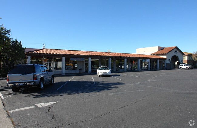
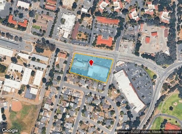
Property Record
1211 Maricopa Hwy, Ojai, CA 93023
NEARBY LISTINGS FOR SALE OR LEASE
Property Detail
1211 Maricopa Hwy
Oxnard-Thousand Oaks-Ventura, CA
Ojai Terrace
017-0-302-105
LOT: 157 REF: 022MR 024
Regionalshoppingcenterormallwithanchorstore
Ventura
X
California
06111C0559F
157
2024
2.31 AC
2025
Ojai/NW County
001002
Los Angeles
660 SF
DEMOGRAPHICS near 1211 Maricopa Hwy
1 Mile
3 Mile
5 Mile
2024 Total Population
4,112
19,458
25,156
2029 Population
4,063
19,124
24,715
Pop Growth 2024-2029
(1.19%)
(1.72%)
(1.75%)
Average Age
48
46
46
2024 Total Households
1,677
7,707
9,834
HH Growth 2024-2029
(1.31%)
(1.87%)
(1.91%)
Median Household Inc
$79,392
$87,820
$89,613
Avg Household Size
2.40
2.40
2.50
2024 Avg HH Vehicles
2.00
2.00
2.00
Median Home Value
$730,295
$790,703
$797,009
Median Year Built
1972
1966
1966
Nearby Places
Map Layers
Map Styles
 Street
 Aerial
- Restaurants
- Banks
- Shops
- Fitness
- Groceries
SALE & LEASE HISTORY
LISTING DATE
SALE/LEASE

Feb 18, 2020
For Lease
Dec 02, 2017
For Lease
Nearby Properties
Address
Land Use
TOTAL SIZE
Lot Size
Zoning
Address
Land Use
TOTAL SIZE
Lot Size
Zoning
182.91 AC
Address
Land Use
TOTAL SIZE
Lot Size
Zoning
6.23 AC
Address
Land Use
TOTAL SIZE
Lot Size
Zoning
2.01 AC
C1
Address
Land Use
TOTAL SIZE
Lot Size
Zoning
37,790 SF
5.13 AC
RPD-10U
Address
Land Use
TOTAL SIZE
Lot Size
Zoning
25,301 SF
1.74 AC
BP
Address
Land Use
TOTAL SIZE
Lot Size
Zoning
28.32 AC
RE20
Address
Land Use
TOTAL SIZE
Lot Size
Zoning
5.05 AC
CR
Address
Land Use
TOTAL SIZE
Lot Size
Zoning
534.56 AC
OS40AC
Address
Land Use
TOTAL SIZE
Lot Size
Zoning
1.93 AC
CPD
Address
Land Use
TOTAL SIZE
Lot Size
Zoning
Address
Land Use
TOTAL SIZE
Lot Size
Zoning
126.17 AC
OS20AC
Address
Land Use
TOTAL SIZE
Lot Size
Zoning
12.68 AC
PL
Address
Land Use
TOTAL SIZE
Lot Size
Zoning
1,440 SF
98.32 AC
AE
Address
Land Use
TOTAL SIZE
Lot Size
Zoning
1,028 SF
4.87 AC
Address
Land Use
TOTAL SIZE
Lot Size
Zoning
54,259 SF
2.56 AC
M1
Address
Land Use
TOTAL SIZE
Lot Size
Zoning
2,690 SF
0.80 AC
Address
Land Use
TOTAL SIZE
Lot Size
Zoning
9.70 AC
Address
Land Use
TOTAL SIZE
Lot Size
Zoning
15,668 SF
1.46 AC
CPD
Address
Land Use
TOTAL SIZE
Lot Size
Zoning
494 SF
8.72 AC
OS20AC
Address
Land Use
TOTAL SIZE
Lot Size
Zoning
35,318 SF
2.59 AC
BP
Address
Land Use
TOTAL SIZE
Lot Size
Zoning
29,708 SF
2.08 AC
M1
Address
Land Use
TOTAL SIZE
Lot Size
Zoning
3,452 SF
21.55 AC
AE
Address
Land Use
TOTAL SIZE
Lot Size
Zoning
100 SF
0.61 AC
C1
Address
Land Use
TOTAL SIZE
Lot Size
Zoning
36.30 AC
RA20AC
Address
Land Use
TOTAL SIZE
Lot Size
Zoning
7.09 AC
Address
Land Use
TOTAL SIZE
Lot Size
Zoning
2,395 SF
44.63 AC
Address
Land Use
TOTAL SIZE
Lot Size
Zoning
14,812 SF
1.86 AC
MULT
Address
Land Use
TOTAL SIZE
Lot Size
Zoning
0.67 AC
Address
Land Use
TOTAL SIZE
Lot Size
Zoning
76 AC
OS40AC
Address
Land Use
TOTAL SIZE
Lot Size
Zoning
404.15 AC
OS40AC
The World's #1 Commercial Real Estate Marketplace
Connect with us
© 2025 CoStar Group
The information above has been obtained from sources believed reliable. While we do not doubt its accuracy we have not verified it and make no guarantee, warranty or representation about it. It is your responsibility to independently confirm its accuracy and completeness. Any projections, opinions, assumptions, or estimates used are for example only and do not represent the current or future performance of the property. The value of this transaction to you depends on tax and other factors which should be evaluated by your tax, financial, and legal advisors. You and your advisors should conduct a careful, independent investigation of the property to determine to your satisfaction the suitability of the property for your needs.