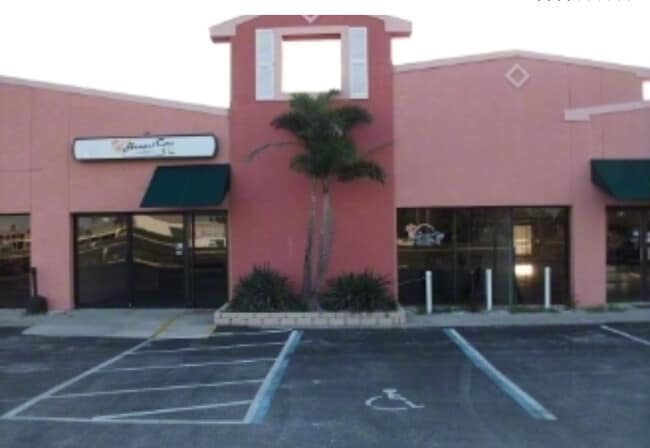
Property Record
1201 Us Highway 19, Holiday, FL 34691


Current Lease Availabilities
NEARBY LISTINGS FOR SALE OR LEASE
Property Detail
1201 Us Highway 19
Tampa-St. Petersburg-Clearwater, FL
Pappas - Colony - Subdivision
31-26-16-0120-00A00-0100
PAPPAS COLONY SUB PB 5 PG 4 THE SOUTH 140.00 FT OF THE FOLLOWING DESC: BEG AT SW COR OF LOT 9 BLOCK A TH ALG WLY BDY LINE OF PAPAS COLONY SUBDIVISION ALSO BEING THE ELY BDY LINE OF PAPAS COLONY SUBDIVISION SECOND ADDITION PB 4 PG 62 TH N01DEG 2142E 2
Commercialacreage
Pasco
X
Florida
12103C0036H
1
2024
0.09 AC
2026
Pasco County
030412
Tampa/St Petersburg
7,875 SF
DEMOGRAPHICS near 1201 Us Highway 19
1 Mile
3 Mile
5 Mile
2024 Total Population
11,803
73,352
150,919
2029 Population
13,794
85,172
173,177
Pop Growth 2024-2029
+ 16.87%
+ 16.11%
+ 14.75%
Average Age
44
44
45
2024 Total Households
5,192
31,444
65,244
HH Growth 2024-2029
+ 17.80%
+ 16.07%
+ 14.68%
Median Household Inc
$38,042
$45,262
$51,137
Avg Household Size
2.20
2.30
2.30
2024 Avg HH Vehicles
2.00
2.00
2.00
Median Home Value
$94,460
$162,803
$222,598
Median Year Built
1975
1977
1980
Nearby Places
Map Layers
Map Styles
 Street
 Aerial
- Restaurants
- Banks
- Shops
- Fitness
- Groceries
PUBLIC TRANSPORTATION
AIRPORT
Tampa International
DRIVE
WALK
Distance
Tampa International
41 min
24.6 mi
St Pete-Clearwater International
DRIVE
WALK
Distance
St Pete-Clearwater International
41 min
24.7 mi
Freight Ports
Port of Tampa Bay
DRIVE
WALK
Distance
Port of Tampa Bay
55 min
33.0 mi
Nearby Properties
Address
Land Use
TOTAL SIZE
Lot Size
Zoning
Address
Land Use
TOTAL SIZE
Lot Size
Zoning
314,948 SF
55.04 AC
MPUD
Address
Land Use
TOTAL SIZE
Lot Size
Zoning
202,954 SF
49.22 AC
AR
Address
Land Use
TOTAL SIZE
Lot Size
Zoning
333,044 SF
25.64 AC
R4
Address
Land Use
TOTAL SIZE
Lot Size
Zoning
154,033 SF
15.86 AC
Address
Land Use
TOTAL SIZE
Lot Size
Zoning
157,476 SF
27.47 AC
MPUD
Address
Land Use
TOTAL SIZE
Lot Size
Zoning
264.64 AC
AC
Address
Land Use
TOTAL SIZE
Lot Size
Zoning
151,825 SF
18.01 AC
Address
Land Use
TOTAL SIZE
Lot Size
Zoning
145,216 SF
7.58 AC
MF3
Address
Land Use
TOTAL SIZE
Lot Size
Zoning
131,819 SF
11.24 AC
Address
Land Use
TOTAL SIZE
Lot Size
Zoning
81,053 SF
9.52 AC
Address
Land Use
TOTAL SIZE
Lot Size
Zoning
121,869 SF
4.72 AC
C2
Address
Land Use
TOTAL SIZE
Lot Size
Zoning
43,469 SF
11.48 AC
MPUD
Address
Land Use
TOTAL SIZE
Lot Size
Zoning
141,763 SF
12.96 AC
Address
Land Use
TOTAL SIZE
Lot Size
Zoning
81,045 SF
16.34 AC
PUD
Address
Land Use
TOTAL SIZE
Lot Size
Zoning
77,900 SF
10.52 AC
C2
Address
Land Use
TOTAL SIZE
Lot Size
Zoning
80,212 SF
6.64 AC
Address
Land Use
TOTAL SIZE
Lot Size
Zoning
77,716 SF
2.54 AC
Address
Land Use
TOTAL SIZE
Lot Size
Zoning
203,135 SF
41.04 AC
C2
Address
Land Use
TOTAL SIZE
Lot Size
Zoning
143,430 SF
8.68 AC
Address
Land Use
TOTAL SIZE
Lot Size
Zoning
74,641 SF
9.20 AC
C2
Address
Land Use
TOTAL SIZE
Lot Size
Zoning
87,794 SF
7.97 AC
Address
Land Use
TOTAL SIZE
Lot Size
Zoning
70,901 SF
5.70 AC
Address
Land Use
TOTAL SIZE
Lot Size
Zoning
44,321 SF
9.65 AC
Address
Land Use
TOTAL SIZE
Lot Size
Zoning
59,196 SF
4.41 AC
Address
Land Use
TOTAL SIZE
Lot Size
Zoning
77,384 SF
6.32 AC
Address
Land Use
TOTAL SIZE
Lot Size
Zoning
22,216 SF
7.20 AC
C2
Address
Land Use
TOTAL SIZE
Lot Size
Zoning
72,796 SF
2.62 AC
MF3
Address
Land Use
TOTAL SIZE
Lot Size
Zoning
65,939 SF
7.23 AC
C2
Address
Land Use
TOTAL SIZE
Lot Size
Zoning
90,892 SF
8.80 AC
Address
Land Use
TOTAL SIZE
Lot Size
Zoning
40.42 AC
The World's #1 Commercial Real Estate Marketplace
Connect with us
© 2026 CoStar Group
The information above has been obtained from sources believed reliable. While we do not doubt its accuracy we have not verified it and make no guarantee, warranty or representation about it. It is your responsibility to independently confirm its accuracy and completeness. Any projections, opinions, assumptions, or estimates used are for example only and do not represent the current or future performance of the property. The value of this transaction to you depends on tax and other factors which should be evaluated by your tax, financial, and legal advisors. You and your advisors should conduct a careful, independent investigation of the property to determine to your satisfaction the suitability of the property for your needs.