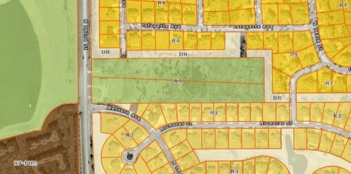
Property Record
1201 N 192Nd St, Elkhorn, NE 68022
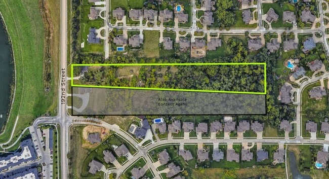
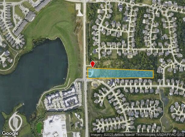
This Property Is For Sale
NEARBY LISTINGS FOR SALE OR LEASE
Property Detail
1201 N 192Nd St
Omaha-Council Bluffs, NE-IA
Lands
1894-0003-01
Douglas
Sfr
Nebraska
X
4.90 AC
31055C0189J
Suburban West Dodge
1,368 SF
Omaha/Council Bluffs
DEMOGRAPHICS near 1201 N 192Nd St
1 Mile
3 Mile
5 Mile
2024 Total Population
7,059
62,299
144,388
2029 Population
7,254
63,275
146,670
Pop Growth 2024-2029
+ 2.76%
+ 1.57%
+ 1.58%
Average Age
37
38
38
2024 Total Households
2,990
22,385
52,589
HH Growth 2024-2029
+ 2.64%
+ 1.59%
+ 1.52%
Median Household Inc
$119,035
$129,436
$117,185
Avg Household Size
2.30
2.70
2.70
2024 Avg HH Vehicles
2.00
2.00
2.00
Median Home Value
$428,013
$354,859
$312,094
Median Year Built
2010
2004
2000
Nearby Places
- Restaurants
- Banks
- Shops
- Fitness
- Groceries
PUBLIC TRANSPORTATION
AIRPORT
Eppley Airfield
DRIVE
WALK
Distance
Eppley Airfield
36 min
19.1 mi
Freight Ports
Tulsa Port Of Catoosa
DRIVE
WALK
Distance
Tulsa Port Of Catoosa
483 min
433.5 mi
Nearby Properties
Address
Land Use
TOTAL SIZE
Lot Size
Zoning
Address
Land Use
TOTAL SIZE
Lot Size
Zoning
443,045 SF
22.82 AC
Address
Land Use
TOTAL SIZE
Lot Size
Zoning
486,568 SF
51.70 AC
ELKHORN
Address
Land Use
TOTAL SIZE
Lot Size
Zoning
420,483 SF
18.51 AC
R6
Address
Land Use
TOTAL SIZE
Lot Size
Zoning
449,891 SF
11.32 AC
Address
Land Use
TOTAL SIZE
Lot Size
Zoning
362,573 SF
2.01 AC
Address
Land Use
TOTAL SIZE
Lot Size
Zoning
223,975 SF
11.91 AC
Address
Land Use
TOTAL SIZE
Lot Size
Zoning
299,172 SF
13.80 AC
R7
Address
Land Use
TOTAL SIZE
Lot Size
Zoning
114,840 SF
4.50 AC
Address
Land Use
TOTAL SIZE
Lot Size
Zoning
104,473 SF
0.78 AC
MU
Address
Land Use
TOTAL SIZE
Lot Size
Zoning
240,630 SF
5.38 AC
Address
Land Use
TOTAL SIZE
Lot Size
Zoning
241,312 SF
14.51 AC
Address
Land Use
TOTAL SIZE
Lot Size
Zoning
226,792 SF
8.97 AC
GO
Address
Land Use
TOTAL SIZE
Lot Size
Zoning
88,928 SF
6.17 AC
Address
Land Use
TOTAL SIZE
Lot Size
Zoning
226,780 SF
8.23 AC
Address
Land Use
TOTAL SIZE
Lot Size
Zoning
341,379 SF
18.08 AC
Address
Land Use
TOTAL SIZE
Lot Size
Zoning
232,559 SF
13.53 AC
R6
Address
Land Use
TOTAL SIZE
Lot Size
Zoning
215,645 SF
5.19 AC
Address
Land Use
TOTAL SIZE
Lot Size
Zoning
233,520 SF
15.39 AC
Address
Land Use
TOTAL SIZE
Lot Size
Zoning
355,421 SF
18.66 AC
Address
Land Use
TOTAL SIZE
Lot Size
Zoning
121,017 SF
13.23 AC
Address
Land Use
TOTAL SIZE
Lot Size
Zoning
168,896 SF
8.79 AC
MU
Address
Land Use
TOTAL SIZE
Lot Size
Zoning
222,090 SF
7.74 AC
R6
Address
Land Use
TOTAL SIZE
Lot Size
Zoning
137,800 SF
6.69 AC
Address
Land Use
TOTAL SIZE
Lot Size
Zoning
143,817 SF
12.27 AC
Address
Land Use
TOTAL SIZE
Lot Size
Zoning
149,113 SF
7.64 AC
R6
Address
Land Use
TOTAL SIZE
Lot Size
Zoning
99,347 SF
4.50 AC
Address
Land Use
TOTAL SIZE
Lot Size
Zoning
96,764 SF
5.48 AC
MU
Address
Land Use
TOTAL SIZE
Lot Size
Zoning
108,211 SF
6.53 AC
Address
Land Use
TOTAL SIZE
Lot Size
Zoning
107,052 SF
5.55 AC
Address
Land Use
TOTAL SIZE
Lot Size
Zoning
149,976 SF
7.15 AC
The World's #1 Commercial Real Estate Marketplace
Connect with us
© 2025 CoStar Group
The information above has been obtained from sources believed reliable. While we do not doubt its accuracy we have not verified it and make no guarantee, warranty or representation about it. It is your responsibility to independently confirm its accuracy and completeness. Any projections, opinions, assumptions, or estimates used are for example only and do not represent the current or future performance of the property. The value of this transaction to you depends on tax and other factors which should be evaluated by your tax, financial, and legal advisors. You and your advisors should conduct a careful, independent investigation of the property to determine to your satisfaction the suitability of the property for your needs.