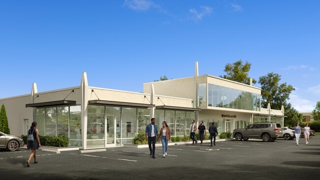
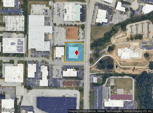
Property Record
1201 N Warson Rd, Saint Louis, MO 63132
Current Lease Availabilities
NEARBY LISTINGS FOR SALE OR LEASE
-
-
No Photo
-
-
-
-
-
-
View all Saint Louis listings for lease on LoopNet.com
Property Detail
1201 N Warson Rd
St. Louis, MO-IL
Lindbergh Warson Ind Center Addn No 1
16M-24-0241
LINDBERGH WARSON IND CENTER ADDN NO 1 SECS 2 THRU 4 RESUB LOT PTS 6 & 8 W LN WARSON RD & N LN GATE WAY BLVD
Officebuilding
St. Louis
X
Missouri
29189C0192K
6,8
2024
1.23 AC
2025
Innerbelt W of 170
215600
St. Louis
18,817 SF
DEMOGRAPHICS near 1201 N Warson Rd
1 Mile
3 Mile
5 Mile
2024 Total Population
9,189
78,505
218,793
2029 Population
9,065
77,253
215,544
Pop Growth 2024-2029
(1.35%)
(1.59%)
(1.48%)
Average Age
40
41
41
2024 Total Households
4,158
34,054
94,396
HH Growth 2024-2029
(1.54%)
(1.60%)
(1.51%)
Median Household Inc
$66,750
$65,180
$71,716
Avg Household Size
2.20
2.20
2.20
2024 Avg HH Vehicles
2.00
2.00
2.00
Median Home Value
$250,764
$223,251
$243,084
Median Year Built
1970
1962
1962
Nearby Places
- Restaurants
- Banks
- Shops
- Fitness
- Groceries
PUBLIC TRANSPORTATION
COMMUTER RAIL
Clayton (Shrewsbury-Lansdowne I-44 Emerson Park - St. Louis MetroLink (MetroLink))
DRIVE
WALK
Distance
Clayton (Shrewsbury-Lansdowne I-44 Emerson Park - St. Louis MetroLink (MetroLink))
9 min
5.0 mi
Forsyth (Shrewsbury-Lansdowne I-44 Emerson Park - St. Louis MetroLink (MetroLink))
DRIVE
WALK
Distance
Forsyth (Shrewsbury-Lansdowne I-44 Emerson Park - St. Louis MetroLink (MetroLink))
12 min
6.3 mi
AIRPORT
St Louis Lambert International
DRIVE
WALK
Distance
St Louis Lambert International
15 min
8.7 mi
Freight Ports
Port Milwaukee
DRIVE
WALK
Distance
Port Milwaukee
436 min
383.2 mi
Nearby Properties
Address
Land Use
TOTAL SIZE
Lot Size
Zoning
Address
Land Use
TOTAL SIZE
Lot Size
Zoning
1,053,686 SF
31.40 AC
43M-1
Address
Land Use
TOTAL SIZE
Lot Size
Zoning
52.13 AC
42PA
Address
Land Use
TOTAL SIZE
Lot Size
Zoning
201,879 SF
29.52 AC
82RO
Address
Land Use
TOTAL SIZE
Lot Size
Zoning
56.62 AC
82A
Address
Land Use
TOTAL SIZE
Lot Size
Zoning
1,280,539 SF
151.20 AC
H
Address
Land Use
TOTAL SIZE
Lot Size
Zoning
544,556 SF
95.75 AC
H
Address
Land Use
TOTAL SIZE
Lot Size
Zoning
292,543 SF
10.11 AC
CB
Address
Land Use
TOTAL SIZE
Lot Size
Zoning
26.89 AC
C-8
Address
Land Use
TOTAL SIZE
Lot Size
Zoning
337,354 SF
7.40 AC
82CB
Address
Land Use
TOTAL SIZE
Lot Size
Zoning
46,752 SF
3.67 AC
82CB
Address
Land Use
TOTAL SIZE
Lot Size
Zoning
234,421 SF
2.01 AC
82CB
Address
Land Use
TOTAL SIZE
Lot Size
Zoning
228,816 SF
1.70 AC
82CB
Address
Land Use
TOTAL SIZE
Lot Size
Zoning
290,380 SF
9.97 AC
82CB
Address
Land Use
TOTAL SIZE
Lot Size
Zoning
297,247 SF
5.40 AC
82CB
Address
Land Use
TOTAL SIZE
Lot Size
Zoning
386,784 SF
6.50 AC
57HDR/O
Address
Land Use
TOTAL SIZE
Lot Size
Zoning
288,322 SF
19.72 AC
104PDM
Address
Land Use
TOTAL SIZE
Lot Size
Zoning
249,369 SF
6 AC
57HDR/O
Address
Land Use
TOTAL SIZE
Lot Size
Zoning
160,628 SF
1.47 AC
82R0
Address
Land Use
TOTAL SIZE
Lot Size
Zoning
57,010 SF
2.42 AC
57GC
Address
Land Use
TOTAL SIZE
Lot Size
Zoning
3,154 SF
38.36 AC
33C
Address
Land Use
TOTAL SIZE
Lot Size
Zoning
55.75 AC
33C
Address
Land Use
TOTAL SIZE
Lot Size
Zoning
193,158 SF
3.60 AC
82GC
Address
Land Use
TOTAL SIZE
Lot Size
Zoning
30 AC
82A
Address
Land Use
TOTAL SIZE
Lot Size
Zoning
14,371 SF
22.26 AC
84R-2
Address
Land Use
TOTAL SIZE
Lot Size
Zoning
181,103 SF
7.57 AC
82CB
Address
Land Use
TOTAL SIZE
Lot Size
Zoning
9,360 SF
30.94 AC
FP
Address
Land Use
TOTAL SIZE
Lot Size
Zoning
8,614 SF
61.03 AC
25R-1
Address
Land Use
TOTAL SIZE
Lot Size
Zoning
172,059 SF
25.52 AC
R1
Address
Land Use
TOTAL SIZE
Lot Size
Zoning
2.89 AC
F
Address
Land Use
TOTAL SIZE
Lot Size
Zoning
362,986 SF
30.31 AC
R6
The World's #1 Commercial Real Estate Marketplace
Connect with us
© 2025 CoStar Group
The information above has been obtained from sources believed reliable. While we do not doubt its accuracy we have not verified it and make no guarantee, warranty or representation about it. It is your responsibility to independently confirm its accuracy and completeness. Any projections, opinions, assumptions, or estimates used are for example only and do not represent the current or future performance of the property. The value of this transaction to you depends on tax and other factors which should be evaluated by your tax, financial, and legal advisors. You and your advisors should conduct a careful, independent investigation of the property to determine to your satisfaction the suitability of the property for your needs.