Property Record
1201 4Th St, Port Huron, MI 48060


Save to a Folder
{{folder.Name}}
{{folder.ListingIds.length}} Properties
{{folder.ListingIds.length}} Property
Create a New Folder
Property Detail
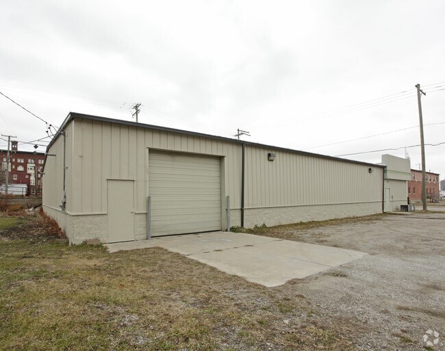
1201 4Th St
06-238-0007-100
LOTS 1, 2, 3 & 4 INCL W 1/2 VAC ALLEY ADJ, LOT 12 INCL VAC ALLEY 10 FT WIDE LYING N OF SAID LOT, LOTS 13, 14 15, 16, 17, 18, 19, 20, 21, & 22 INCL E 1/2 VAC ALLEY ADJ TO LOT 19 THE BANKS SUBDIVISION OF LOTS 28, 29, 31, 33, 34, 36, 38 & 40 OF WHAT IS
Storemultistory
Saint Clair
CBD
Michigan
B and X Area of moderate flood hazard, usually the area between the limits of the 100-year and 500-year floods.
1-4,12
2025
1 AC
2025
St Clair & Lapeer Counties
624000
Detroit
8,160 SF
Detroit-Warren-Dearborn, MI
NEARBY LISTINGS FOR SALE OR LEASE
-
-
-
-
-
-
-
-
-
No Photo
-
View all Port Huron listings for sale on LoopNet.com
DEMOGRAPHICS near 1201 4Th St
1 mile
3 mile
5 mile
2025 Total Population
9,304
29,503
51,297
2030 Population
9,359
29,433
51,116
Pop Growth 2025-2030
+ 0.59%
(0.24%)
(0.35%)
Average Age
39
40
41
2025 Total Households
3,995
12,166
21,341
HH Growth 2025-2030
+ 0.70%
(0.29%)
(0.43%)
Median Household Inc
$37,580
$47,610
$56,083
Avg Household Size
2.20
2.30
2.30
2025 Avg HH Vehicles
1.00
2.00
2.00
Median Home Value
$110,523
$148,004
$175,497
Median Year Built
1949
1955
1966
Nearby Places
Map Layers
Map Styles
 Street
 Aerial
Layers
 Traffic
 Biking
Places
Listings with unknown addresses are not visible on the map
- Restaurants
- Banks
- Shops
- Fitness
- Groceries
PUBLIC TRANSPORTATION
COMMUTER RAIL
Drive
Walk
Distance
4 min
1.8 mi
Drive
Walk
Distance
17 min
7.5 mi
SALE & LEASE HISTORY
LISTING DATE
SALE/LEASE

Sep 24, 2016
For Lease
Sep 24, 2016
For Sale
Sep 13, 2017
For Lease
Jan 26, 2023
For Sale
Apr 16, 2021
For Lease
Nearby Properties
Address
Land Use
TOTAL SIZE
Lot Size
Zoning
Address
Land Use
TOTAL SIZE
Lot Size
Zoning
206,565 SF
22.08 AC
I
Address
Land Use
TOTAL SIZE
Lot Size
Zoning
241,664 SF
50.15 AC
B-3
Address
Land Use
TOTAL SIZE
Lot Size
Zoning
Address
Land Use
TOTAL SIZE
Lot Size
Zoning
88,524 SF
1.41 AC
CBD
Address
Land Use
TOTAL SIZE
Lot Size
Zoning
Address
Land Use
TOTAL SIZE
Lot Size
Zoning
115,172 SF
11.29 AC
A1
Address
Land Use
TOTAL SIZE
Lot Size
Zoning
83,563 SF
7.46 AC
CBD
Address
Land Use
TOTAL SIZE
Lot Size
Zoning
173,584 SF
9.50 AC
M1
Address
Land Use
TOTAL SIZE
Lot Size
Zoning
Address
Land Use
TOTAL SIZE
Lot Size
Zoning
149,732 SF
12.48 AC
M1
Address
Land Use
TOTAL SIZE
Lot Size
Zoning
109,097 SF
6.47 AC
A2
Address
Land Use
TOTAL SIZE
Lot Size
Zoning
40,690 SF
0.89 AC
CBD
Address
Land Use
TOTAL SIZE
Lot Size
Zoning
76,352 SF
4.88 AC
C1
Address
Land Use
TOTAL SIZE
Lot Size
Zoning
137,720 SF
12.04 AC
B-3
Address
Land Use
TOTAL SIZE
Lot Size
Zoning
94,537 SF
12.63 AC
B-3
Address
Land Use
TOTAL SIZE
Lot Size
Zoning
112,566 SF
7.20 AC
B-3
Address
Land Use
TOTAL SIZE
Lot Size
Zoning
73,882 SF
6.50 AC
B-3
Address
Land Use
TOTAL SIZE
Lot Size
Zoning
39,547 SF
A1
Address
Land Use
TOTAL SIZE
Lot Size
Zoning
33,810 SF
0.92 AC
CBD
Address
Land Use
TOTAL SIZE
Lot Size
Zoning
140,230 SF
7.90 AC
M1
Address
Land Use
TOTAL SIZE
Lot Size
Zoning
333,076 SF
23.19 AC
M2
Address
Land Use
TOTAL SIZE
Lot Size
Zoning
85,200 SF
4.23 AC
M1
Address
Land Use
TOTAL SIZE
Lot Size
Zoning
0.32 AC
CBD
Address
Land Use
TOTAL SIZE
Lot Size
Zoning
28,225 SF
3.74 AC
C1
Address
Land Use
TOTAL SIZE
Lot Size
Zoning
45,750 SF
M1
Address
Land Use
TOTAL SIZE
Lot Size
Zoning
26,962 SF
3.03 AC
C1
Address
Land Use
TOTAL SIZE
Lot Size
Zoning
198,647 SF
26.04 AC
B-3
Address
Land Use
TOTAL SIZE
Lot Size
Zoning
168,310 SF
8.90 AC
M1
Address
Land Use
TOTAL SIZE
Lot Size
Zoning
118,606 SF
9.15 AC
A1
Address
Land Use
TOTAL SIZE
Lot Size
Zoning
105,269 SF
6 AC
M1
The World's #1 Commercial Real Estate Marketplace
Connect with us
© 2026 CoStar Group
The information above has been obtained from sources believed reliable. While we do not doubt its accuracy we have not verified it and make no guarantee, warranty or representation about it. It is your responsibility to independently confirm its accuracy and completeness. Any projections, opinions, assumptions, or estimates used are for example only and do not represent the current or future performance of the property. The value of this transaction to you depends on tax and other factors which should be evaluated by your tax, financial, and legal advisors. You and your advisors should conduct a careful, independent investigation of the property to determine to your satisfaction the suitability of the property for your needs.