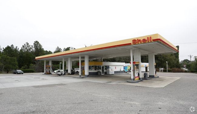
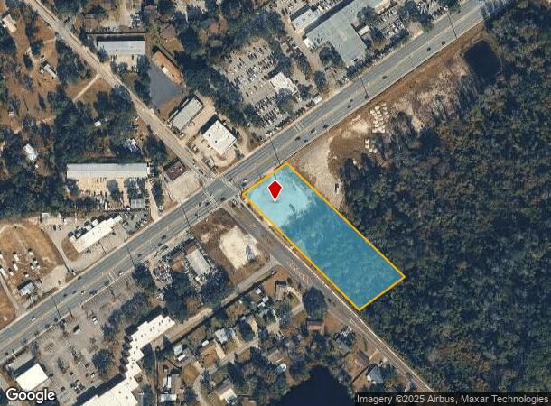
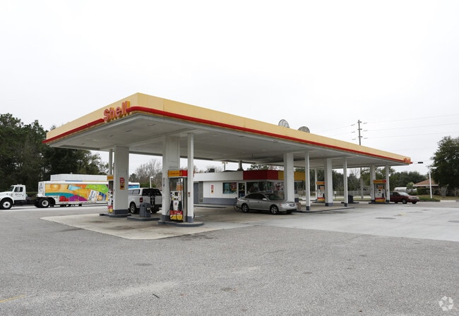
Property Record
1201 Blanding Blvd, Orange Park, FL 32065

NEARBY LISTINGS FOR SALE OR LEASE
Property Detail
1201 Blanding Blvd
Jacksonville, FL
Ridgewood
40-04-25-020895-008-00
PT LOT 8 RIDGEWOOD SEC 24 O.P. AS REC OR 4567 PG 533
Commercialacreage
Clay
X
Florida
12019C0070E
8
2024
2.71 AC
2025
Orange Park/Clay County
030906
Jacksonville (Florida)
1,418 SF
DEMOGRAPHICS near 1201 Blanding Blvd
1 Mile
3 Mile
5 Mile
2024 Total Population
6,946
41,695
125,904
2029 Population
7,495
45,348
136,931
Pop Growth 2024-2029
+ 7.90%
+ 8.76%
+ 8.76%
Average Age
39
40
39
2024 Total Households
2,691
15,194
44,316
HH Growth 2024-2029
+ 8.03%
+ 8.79%
+ 8.77%
Median Household Inc
$72,693
$80,825
$86,370
Avg Household Size
2.60
2.70
2.80
2024 Avg HH Vehicles
2.00
2.00
2.00
Median Home Value
$158,219
$232,816
$260,849
Median Year Built
1984
1988
1995
Nearby Places
- Restaurants
- Banks
- Shops
- Fitness
- Groceries
PUBLIC TRANSPORTATION
AIRPORT
Jacksonville International
DRIVE
WALK
Distance
Jacksonville International
47 min
32.1 mi
Freight Ports
Jacksonville Port
DRIVE
WALK
Distance
Jacksonville Port
41 min
25.9 mi
SALE & LEASE HISTORY
LISTING DATE
SALE/LEASE

Apr 15, 2025
For Sale
Nearby Properties
Address
Land Use
TOTAL SIZE
Lot Size
Zoning
Address
Land Use
TOTAL SIZE
Lot Size
Zoning
340,385 SF
28.98 AC
Address
Land Use
TOTAL SIZE
Lot Size
Zoning
799,320 SF
150.55 AC
Address
Land Use
TOTAL SIZE
Lot Size
Zoning
241,396 SF
37.78 AC
Address
Land Use
TOTAL SIZE
Lot Size
Zoning
257,608 SF
27.17 AC
Address
Land Use
TOTAL SIZE
Lot Size
Zoning
233,551 SF
18.96 AC
PUD
Address
Land Use
TOTAL SIZE
Lot Size
Zoning
148,895 SF
35.72 AC
PO-1
Address
Land Use
TOTAL SIZE
Lot Size
Zoning
297,028 SF
16.78 AC
PUD
Address
Land Use
TOTAL SIZE
Lot Size
Zoning
207,472 SF
13.39 AC
RD-4
Address
Land Use
TOTAL SIZE
Lot Size
Zoning
83,621 SF
26.35 AC
Address
Land Use
TOTAL SIZE
Lot Size
Zoning
141,441 SF
82.05 AC
Address
Land Use
TOTAL SIZE
Lot Size
Zoning
105,657 SF
28.86 AC
Address
Land Use
TOTAL SIZE
Lot Size
Zoning
175,412 SF
14.27 AC
PUD
Address
Land Use
TOTAL SIZE
Lot Size
Zoning
173,163 SF
18.32 AC
BSC
Address
Land Use
TOTAL SIZE
Lot Size
Zoning
174,016 SF
8.12 AC
Address
Land Use
TOTAL SIZE
Lot Size
Zoning
106,486 SF
24.23 AC
PS-1
Address
Land Use
TOTAL SIZE
Lot Size
Zoning
89,513 SF
19.76 AC
Address
Land Use
TOTAL SIZE
Lot Size
Zoning
209,568 SF
24.51 AC
PCD
Address
Land Use
TOTAL SIZE
Lot Size
Zoning
70,640 SF
7.15 AC
Address
Land Use
TOTAL SIZE
Lot Size
Zoning
113,473 SF
14.90 AC
Address
Land Use
TOTAL SIZE
Lot Size
Zoning
59,700 SF
0.58 AC
Address
Land Use
TOTAL SIZE
Lot Size
Zoning
109,200 SF
3.89 AC
BB-3
Address
Land Use
TOTAL SIZE
Lot Size
Zoning
140,280 SF
10.74 AC
Address
Land Use
TOTAL SIZE
Lot Size
Zoning
83,680 SF
7.86 AC
Address
Land Use
TOTAL SIZE
Lot Size
Zoning
110,457 SF
4.07 AC
BB
Address
Land Use
TOTAL SIZE
Lot Size
Zoning
67,862 SF
58 AC
Address
Land Use
TOTAL SIZE
Lot Size
Zoning
114,583 SF
14.83 AC
Address
Land Use
TOTAL SIZE
Lot Size
Zoning
105,513 SF
3.55 AC
Address
Land Use
TOTAL SIZE
Lot Size
Zoning
105,513 SF
3.25 AC
Address
Land Use
TOTAL SIZE
Lot Size
Zoning
125,604 SF
23.77 AC
Address
Land Use
TOTAL SIZE
Lot Size
Zoning
49,712 SF
14.29 AC
PS-1
The World's #1 Commercial Real Estate Marketplace
Connect with us
© 2025 CoStar Group
The information above has been obtained from sources believed reliable. While we do not doubt its accuracy we have not verified it and make no guarantee, warranty or representation about it. It is your responsibility to independently confirm its accuracy and completeness. Any projections, opinions, assumptions, or estimates used are for example only and do not represent the current or future performance of the property. The value of this transaction to you depends on tax and other factors which should be evaluated by your tax, financial, and legal advisors. You and your advisors should conduct a careful, independent investigation of the property to determine to your satisfaction the suitability of the property for your needs.