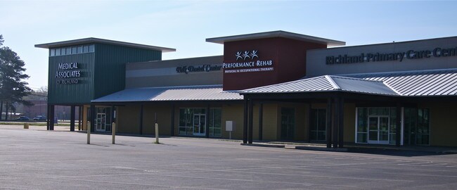
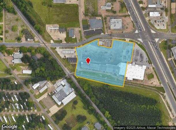
Property Record
1201 Highway 49 S, Richland, MS 39218
NEARBY LISTINGS FOR SALE OR LEASE
Property Detail
1201 Highway 49 S
Jackson, MS
Riverwood Village Revision
D06K-000015-00010
LOT 1 RIVERWOOD VILLAGE REVISION FORMERLY KNOW AS 6.10 A IN S2 SW4 S OF SCARBOROUGH DR W OF H/W 49 E OF RR DB 460 PG 0571 003
Stripcommercialcenter
Rankin
AE
Mississippi
28121C0309F
1
2024
6.10 AC
2024
Outlying Rankin County
020401
Jackson
36,414 SF
DEMOGRAPHICS near 1201 Highway 49 S
1 Mile
3 Mile
5 Mile
2024 Total Population
5,608
11,297
37,789
2029 Population
5,780
11,692
38,600
Pop Growth 2024-2029
+ 3.07%
+ 3.50%
+ 2.15%
Average Age
38
39
39
2024 Total Households
2,104
4,248
13,444
HH Growth 2024-2029
+ 3.14%
+ 3.55%
+ 2.28%
Median Household Inc
$52,853
$49,274
$47,669
Avg Household Size
2.60
2.60
2.50
2024 Avg HH Vehicles
2.00
2.00
2.00
Median Home Value
$126,876
$127,702
$141,328
Median Year Built
1993
1991
1984
Nearby Places
Map Layers
Map Styles
 Street
 Aerial
- Restaurants
- Banks
- Shops
- Fitness
- Groceries
PUBLIC TRANSPORTATION
COMMUTER RAIL
Jackson (City of New Orleans - Amtrak)
DRIVE
WALK
Distance
Jackson (City of New Orleans - Amtrak)
13 min
8.5 mi
AIRPORT
Jackson-Medgar Wiley Evers International
DRIVE
WALK
Distance
Jackson-Medgar Wiley Evers International
20 min
12.4 mi
Freight Ports
Port of Greater Baton Rouge
DRIVE
WALK
Distance
Port of Greater Baton Rouge
203 min
181.2 mi
SALE & LEASE HISTORY
LISTING DATE
SALE/LEASE

Sep 25, 2016
For Lease
Mar 11, 2020
For Lease
Nearby Properties
Address
Land Use
TOTAL SIZE
Lot Size
Zoning
Address
Land Use
TOTAL SIZE
Lot Size
Zoning
58.94 AC
Address
Land Use
TOTAL SIZE
Lot Size
Zoning
253,479 SF
17.08 AC
Address
Land Use
TOTAL SIZE
Lot Size
Zoning
157,034 SF
17.28 AC
Address
Land Use
TOTAL SIZE
Lot Size
Zoning
7,840 SF
10.34 AC
Address
Land Use
TOTAL SIZE
Lot Size
Zoning
24,081 SF
24.48 AC
Address
Land Use
TOTAL SIZE
Lot Size
Zoning
11,796 SF
2.97 AC
Address
Land Use
TOTAL SIZE
Lot Size
Zoning
2,513 SF
7.10 AC
Address
Land Use
TOTAL SIZE
Lot Size
Zoning
7,648 SF
7.10 AC
Address
Land Use
TOTAL SIZE
Lot Size
Zoning
16,095 SF
11.11 AC
Address
Land Use
TOTAL SIZE
Lot Size
Zoning
5,595 SF
7.51 AC
Address
Land Use
TOTAL SIZE
Lot Size
Zoning
12.74 AC
Address
Land Use
TOTAL SIZE
Lot Size
Zoning
9,789 SF
23.22 AC
Address
Land Use
TOTAL SIZE
Lot Size
Zoning
59,724 SF
7.95 AC
Address
Land Use
TOTAL SIZE
Lot Size
Zoning
78,626 SF
3.12 AC
Address
Land Use
TOTAL SIZE
Lot Size
Zoning
24,864 SF
6.10 AC
Address
Land Use
TOTAL SIZE
Lot Size
Zoning
120,296 SF
6.02 AC
Address
Land Use
TOTAL SIZE
Lot Size
Zoning
9,254 SF
18.36 AC
Address
Land Use
TOTAL SIZE
Lot Size
Zoning
38,621 SF
1.88 AC
Address
Land Use
TOTAL SIZE
Lot Size
Zoning
34,329 SF
3 AC
Address
Land Use
TOTAL SIZE
Lot Size
Zoning
1.12 AC
Address
Land Use
TOTAL SIZE
Lot Size
Zoning
981 SF
6 AC
Address
Land Use
TOTAL SIZE
Lot Size
Zoning
67,033 SF
5.84 AC
Address
Land Use
TOTAL SIZE
Lot Size
Zoning
4,810 SF
28.82 AC
Address
Land Use
TOTAL SIZE
Lot Size
Zoning
23,479 SF
4 AC
Address
Land Use
TOTAL SIZE
Lot Size
Zoning
Address
Land Use
TOTAL SIZE
Lot Size
Zoning
9.70 AC
Address
Land Use
TOTAL SIZE
Lot Size
Zoning
42,442 SF
30 AC
Address
Land Use
TOTAL SIZE
Lot Size
Zoning
5,961 SF
14.31 AC
Address
Land Use
TOTAL SIZE
Lot Size
Zoning
22,786 SF
11.92 AC
Address
Land Use
TOTAL SIZE
Lot Size
Zoning
5,150 SF
5.71 AC
The World's #1 Commercial Real Estate Marketplace
Connect with us
© 2026 CoStar Group
The information above has been obtained from sources believed reliable. While we do not doubt its accuracy we have not verified it and make no guarantee, warranty or representation about it. It is your responsibility to independently confirm its accuracy and completeness. Any projections, opinions, assumptions, or estimates used are for example only and do not represent the current or future performance of the property. The value of this transaction to you depends on tax and other factors which should be evaluated by your tax, financial, and legal advisors. You and your advisors should conduct a careful, independent investigation of the property to determine to your satisfaction the suitability of the property for your needs.