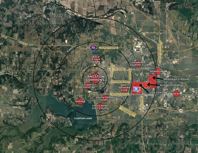
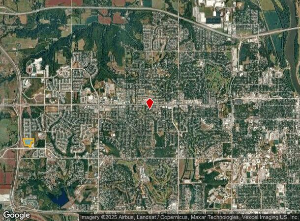
Property Record
1201 Langston Way, Lawrence, KS 66049
This Property Is For Sale
NEARBY LISTINGS FOR SALE OR LEASE
Property Detail
1201 Langston Way
Lawrence, KS
Langston Commons No 2
069-32-0-30-01-002.05-0
LANGSTON COMMONS NO. 3 BLK 1 LOT 2 (REPLAT 2023)
Agriculturalland
Douglas
X
Kansas
20045C0154D
2
2025
11.90 AC
2025
Lawrence
000701
Kansas City
DEMOGRAPHICS near 1201 Langston Way
1 Mile
3 Mile
5 Mile
2024 Total Population
4,445
30,428
76,706
2029 Population
4,565
30,929
78,090
Pop Growth 2024-2029
+ 2.70%
+ 1.65%
+ 1.80%
Average Age
39
39
36
2024 Total Households
1,782
13,585
31,995
HH Growth 2024-2029
+ 2.81%
+ 1.78%
+ 2.00%
Median Household Inc
$106,190
$68,860
$56,149
Avg Household Size
2.50
2.20
2.20
2024 Avg HH Vehicles
2.00
2.00
2.00
Median Home Value
$425,754
$342,167
$274,215
Median Year Built
2008
2001
1990
Nearby Places
Map Layers
Map Styles
 Street
 Aerial
- Restaurants
- Banks
- Shops
- Fitness
- Groceries
PUBLIC TRANSPORTATION
COMMUTER RAIL
Lawrence Amtrak Station (Southwest Chief - Amtrak)
DRIVE
WALK
Distance
Lawrence Amtrak Station (Southwest Chief - Amtrak)
6 min
3.5 mi
Freight Ports
Tulsa Port Of Catoosa
DRIVE
WALK
Distance
Tulsa Port Of Catoosa
258 min
214.2 mi
Nearby Properties
Address
Land Use
TOTAL SIZE
Lot Size
Zoning
Address
Land Use
TOTAL SIZE
Lot Size
Zoning
1,709,524 SF
32.03 AC
RD
Address
Land Use
TOTAL SIZE
Lot Size
Zoning
1,258,819 SF
106.65 AC
RD
Address
Land Use
TOTAL SIZE
Lot Size
Zoning
1,264,810 SF
129.10 AC
RD
Address
Land Use
TOTAL SIZE
Lot Size
Zoning
243,311 SF
20.07 AC
AG
Address
Land Use
TOTAL SIZE
Lot Size
Zoning
63,837 SF
20.79 AC
H
Address
Land Use
TOTAL SIZE
Lot Size
Zoning
335,349 SF
3.17 AC
RD
Address
Land Use
TOTAL SIZE
Lot Size
Zoning
112,168 SF
38.08 AC
RD
Address
Land Use
TOTAL SIZE
Lot Size
Zoning
200,960 SF
9.20 AC
RD
Address
Land Use
TOTAL SIZE
Lot Size
Zoning
190,168 SF
55.04 AC
C2
Address
Land Use
TOTAL SIZE
Lot Size
Zoning
249,773 SF
34.84 AC
RS2
Address
Land Use
TOTAL SIZE
Lot Size
Zoning
336,701 SF
5.20 AC
RD
Address
Land Use
TOTAL SIZE
Lot Size
Zoning
112,500 SF
3.90 AC
RM1
Address
Land Use
TOTAL SIZE
Lot Size
Zoning
47,457 SF
2.58 AC
Address
Land Use
TOTAL SIZE
Lot Size
Zoning
220,557 SF
8.90 AC
RD
Address
Land Use
TOTAL SIZE
Lot Size
Zoning
162,086 SF
3 AC
RD
Address
Land Use
TOTAL SIZE
Lot Size
Zoning
143,279 SF
36.20 AC
RS1
Address
Land Use
TOTAL SIZE
Lot Size
Zoning
67,500 SF
4.03 AC
RM1
Address
Land Use
TOTAL SIZE
Lot Size
Zoning
181,346 SF
21.40 AC
497
Address
Land Use
TOTAL SIZE
Lot Size
Zoning
186,889 SF
3.60 AC
RD
Address
Land Use
TOTAL SIZE
Lot Size
Zoning
92,295 SF
10.40 AC
RS1
Address
Land Use
TOTAL SIZE
Lot Size
Zoning
138,043 SF
26.20 AC
AG
Address
Land Use
TOTAL SIZE
Lot Size
Zoning
11,992 SF
118.15 AC
RS1
Address
Land Use
TOTAL SIZE
Lot Size
Zoning
104,785 SF
105.60 AC
RS1
Address
Land Use
TOTAL SIZE
Lot Size
Zoning
1,034 SF
254.80 AC
AG
Address
Land Use
TOTAL SIZE
Lot Size
Zoning
56,172 SF
14.05 AC
AG
Address
Land Use
TOTAL SIZE
Lot Size
Zoning
92,819 SF
3.10 AC
RO2
Address
Land Use
TOTAL SIZE
Lot Size
Zoning
55,556 SF
24.90 AC
RM1
Address
Land Use
TOTAL SIZE
Lot Size
Zoning
52,000 SF
36 AC
RS1
Address
Land Use
TOTAL SIZE
Lot Size
Zoning
19,985 SF
103.37 AC
RS1
Address
Land Use
TOTAL SIZE
Lot Size
Zoning
337,280 SF
0.60 AC
RD
The World's #1 Commercial Real Estate Marketplace
Connect with us
© 2025 CoStar Group
The information above has been obtained from sources believed reliable. While we do not doubt its accuracy we have not verified it and make no guarantee, warranty or representation about it. It is your responsibility to independently confirm its accuracy and completeness. Any projections, opinions, assumptions, or estimates used are for example only and do not represent the current or future performance of the property. The value of this transaction to you depends on tax and other factors which should be evaluated by your tax, financial, and legal advisors. You and your advisors should conduct a careful, independent investigation of the property to determine to your satisfaction the suitability of the property for your needs.