No Photo
Property Record
1201 N 5Th St, Perkasie, PA 18944


Save to a Folder
{{folder.Name}}
{{folder.ListingIds.length}} Properties
{{folder.ListingIds.length}} Property
Create a New Folder
Property Detail
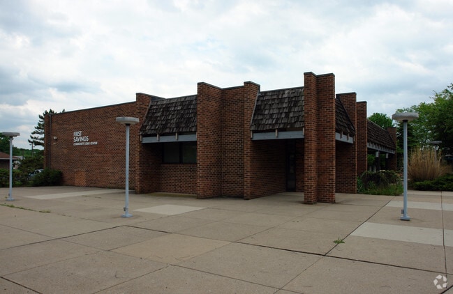
1201 N 5Th St
33-016-032
1.88AC SE COR N FIFTH ST TO BLOOMING GLEN RD
Storebuilding
Bucks
C1
Pennsylvania
B and X Area of moderate flood hazard, usually the area between the limits of the 100-year and 500-year floods.
1.88 AC
2025
Upper Bucks County
2026
Philadelphia
102401
Philadelphia-Camden-Wilmington, PA-NJ-DE-MD
12,788 SF
NEARBY LISTINGS FOR SALE OR LEASE
DEMOGRAPHICS near 1201 N 5Th St
1 mile
3 mile
5 mile
2025 Total Population
5,147
28,850
60,017
2030 Population
5,212
29,084
60,495
Pop Growth 2025-2030
+ 1.26%
+ 0.81%
+ 0.80%
Average Age
41
42
43
2025 Total Households
2,007
11,020
22,998
HH Growth 2025-2030
+ 1.35%
+ 0.79%
+ 0.77%
Median Household Inc
$103,498
$112,216
$106,495
Avg Household Size
2.60
2.60
2.60
2025 Avg HH Vehicles
2.00
2.00
2.00
Median Home Value
$397,399
$410,030
$424,063
Median Year Built
1973
1978
1978
Nearby Places
Map Layers
Map Styles
 Street
 Aerial
Layers
 Traffic
 Biking
Places
Listings with unknown addresses are not visible on the map
- Restaurants
- Banks
- Shops
- Fitness
- Groceries
PUBLIC TRANSPORTATION
COMMUTER RAIL
Chalfont (R5 - Southeastern Pennsylvania Transportation Authority Regional Rail (SEPTA Regional Rail))
Drive
Walk
Distance
Chalfont (R5 - Southeastern Pennsylvania Transportation Authority Regional Rail (SEPTA Regional Rail))
19 min
9.5 mi
AIRPORT
Lehigh Valley International
Drive
Walk
Distance
Lehigh Valley International
47 min
26.6 mi
Trenton Mercer
Drive
Walk
Distance
Trenton Mercer
55 min
32.6 mi
Freight Ports
Port of Philadelphia
Drive
Walk
Distance
Port of Philadelphia
59 min
34.4 mi
Nearby Properties
Address
Land Use
TOTAL SIZE
Lot Size
Zoning
Address
Land Use
TOTAL SIZE
Lot Size
Zoning
256,512 SF
21.31 AC
CR
Address
Land Use
TOTAL SIZE
Lot Size
Zoning
1,261,187 SF
13.86 AC
CR
Address
Land Use
TOTAL SIZE
Lot Size
Zoning
92,018 SF
22.18 AC
I2
Address
Land Use
TOTAL SIZE
Lot Size
Zoning
131,218 SF
14.23 AC
PRD
Address
Land Use
TOTAL SIZE
Lot Size
Zoning
63,433 SF
8.20 AC
CO
Address
Land Use
TOTAL SIZE
Lot Size
Zoning
7.61 AC
CR
Address
Land Use
TOTAL SIZE
Lot Size
Zoning
105,840 SF
2.42 AC
R1B
Address
Land Use
TOTAL SIZE
Lot Size
Zoning
101,920 SF
21.05 AC
R1B
Address
Land Use
TOTAL SIZE
Lot Size
Zoning
39,966 SF
2.78 AC
I2
Address
Land Use
TOTAL SIZE
Lot Size
Zoning
40,000 SF
8.55 AC
I
Address
Land Use
TOTAL SIZE
Lot Size
Zoning
52,819 SF
15.35 AC
CR
Address
Land Use
TOTAL SIZE
Lot Size
Zoning
2,538 SF
4.96 AC
CR
Address
Land Use
TOTAL SIZE
Lot Size
Zoning
12,000 SF
128.21 AC
I1
Address
Land Use
TOTAL SIZE
Lot Size
Zoning
20,106 SF
6.49 AC
A
Address
Land Use
TOTAL SIZE
Lot Size
Zoning
9,680 SF
57.74 AC
Q
Address
Land Use
TOTAL SIZE
Lot Size
Zoning
7,934 SF
11.63 AC
PC1
Address
Land Use
TOTAL SIZE
Lot Size
Zoning
5,525 SF
2.57 AC
PC2
Address
Land Use
TOTAL SIZE
Lot Size
Zoning
14,822 SF
2.95 AC
IS
Address
Land Use
TOTAL SIZE
Lot Size
Zoning
6,810 SF
0.35 AC
R2
Address
Land Use
TOTAL SIZE
Lot Size
Zoning
12,859 SF
2.19 AC
PC2
Address
Land Use
TOTAL SIZE
Lot Size
Zoning
82,313 SF
4.41 AC
R3
Address
Land Use
TOTAL SIZE
Lot Size
Zoning
7,263 SF
0.11 AC
IS
Address
Land Use
TOTAL SIZE
Lot Size
Zoning
33,362 SF
14.97 AC
PI
Address
Land Use
TOTAL SIZE
Lot Size
Zoning
6 AC
I1
Address
Land Use
TOTAL SIZE
Lot Size
Zoning
26,875 SF
3.76 AC
SR
Address
Land Use
TOTAL SIZE
Lot Size
Zoning
10,368 SF
2.02 AC
PC2
Address
Land Use
TOTAL SIZE
Lot Size
Zoning
42,460 SF
5.61 AC
PC2
Address
Land Use
TOTAL SIZE
Lot Size
Zoning
17,766 SF
0.24 AC
C2
Address
Land Use
TOTAL SIZE
Lot Size
Zoning
6,522 SF
0.17 AC
IS
The World's #1 Commercial Real Estate Marketplace
Connect with us
© 2026 CoStar Group
The information above has been obtained from sources believed reliable. While we do not doubt its accuracy we have not verified it and make no guarantee, warranty or representation about it. It is your responsibility to independently confirm its accuracy and completeness. Any projections, opinions, assumptions, or estimates used are for example only and do not represent the current or future performance of the property. The value of this transaction to you depends on tax and other factors which should be evaluated by your tax, financial, and legal advisors. You and your advisors should conduct a careful, independent investigation of the property to determine to your satisfaction the suitability of the property for your needs.