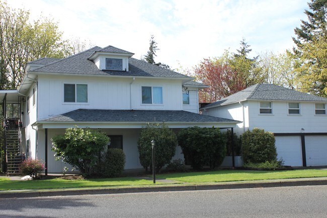
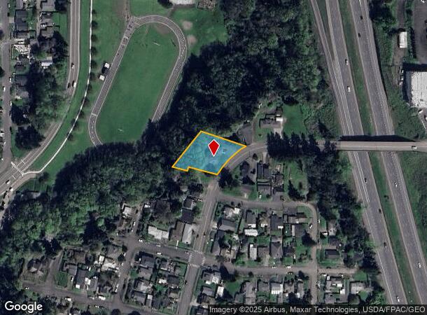
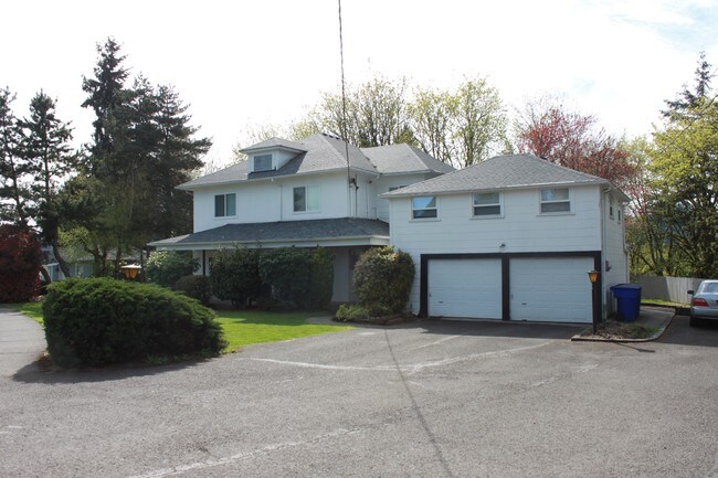
Property Record
1201 N 7Th Ave, Kelso, WA 98626
NEARBY LISTINGS FOR SALE OR LEASE
Property Detail
1201 N 7Th Ave
Longview, WA
Kelso Outlot
2-3813
817 (KELSO OUTLOT) -KEOL -87A, 87B 26 -8N -2W AKA TR ROS 35/66 TR E EXC KEOL 11A FEE 324372 INCL KEOL 87B FEE 3540081 EXC KEOL 87A-1 FEE 3540081.
Apartment
Cowlitz
X
Washington
53015C0519G
87a
2025
0.34 AC
2024
Kelso
001300
Portland
1,192 SF
DEMOGRAPHICS near 1201 N 7Th Ave
1 Mile
3 Mile
5 Mile
2024 Total Population
9,039
42,982
68,576
2029 Population
9,332
44,437
70,984
Pop Growth 2024-2029
+ 3.24%
+ 3.39%
+ 3.51%
Average Age
37
41
41
2024 Total Households
3,481
17,326
27,120
HH Growth 2024-2029
+ 3.36%
+ 3.51%
+ 3.60%
Median Household Inc
$56,790
$64,592
$62,965
Avg Household Size
2.50
2.40
2.50
2024 Avg HH Vehicles
2.00
2.00
2.00
Median Home Value
$300,098
$322,657
$327,115
Median Year Built
1956
1963
1967
Nearby Places
Map Layers
Map Styles
 Street
 Aerial
- Restaurants
- Banks
- Shops
- Fitness
- Groceries
PUBLIC TRANSPORTATION
COMMUTER RAIL
Kelso-Longview (Amtrak Cascades - Amtrak, Coast Starlight - Amtrak)
DRIVE
WALK
Distance
Kelso-Longview (Amtrak Cascades - Amtrak, Coast Starlight - Amtrak)
3 min
19 min
1.0 mi
Freight Ports
Port of Long View, WA
DRIVE
WALK
Distance
Port of Long View, WA
12 min
4.7 mi
SALE & LEASE HISTORY
LISTING DATE
SALE/LEASE

May 18, 2017
For Sale
Jul 27, 2017
For Sale
Nearby Properties
Address
Land Use
TOTAL SIZE
Lot Size
Zoning
Address
Land Use
TOTAL SIZE
Lot Size
Zoning
83,033 SF
27.78 AC
R01
Address
Land Use
TOTAL SIZE
Lot Size
Zoning
40.41 AC
R02
Address
Land Use
TOTAL SIZE
Lot Size
Zoning
10.12 AC
I01
Address
Land Use
TOTAL SIZE
Lot Size
Zoning
139,660 SF
2.76 AC
Address
Land Use
TOTAL SIZE
Lot Size
Zoning
206,926 SF
4.80 AC
C02
Address
Land Use
TOTAL SIZE
Lot Size
Zoning
2.49 AC
Address
Land Use
TOTAL SIZE
Lot Size
Zoning
28.39 AC
M02
Address
Land Use
TOTAL SIZE
Lot Size
Zoning
9.24 AC
C02
Address
Land Use
TOTAL SIZE
Lot Size
Zoning
160,069 SF
20.68 AC
M01
Address
Land Use
TOTAL SIZE
Lot Size
Zoning
48,368 SF
6.32 AC
RF1
Address
Land Use
TOTAL SIZE
Lot Size
Zoning
8.20 AC
C03
Address
Land Use
TOTAL SIZE
Lot Size
Zoning
138,715 SF
7.43 AC
C04
Address
Land Use
TOTAL SIZE
Lot Size
Zoning
157,970 SF
12.36 AC
R01
Address
Land Use
TOTAL SIZE
Lot Size
Zoning
22.50 AC
R01
Address
Land Use
TOTAL SIZE
Lot Size
Zoning
18.59 AC
MH0
Address
Land Use
TOTAL SIZE
Lot Size
Zoning
25.61 AC
R04
Address
Land Use
TOTAL SIZE
Lot Size
Zoning
45,998 SF
1.84 AC
R01
Address
Land Use
TOTAL SIZE
Lot Size
Zoning
129,423 SF
2.34 AC
SR0
Address
Land Use
TOTAL SIZE
Lot Size
Zoning
135,152 SF
0.38 AC
R01
Address
Land Use
TOTAL SIZE
Lot Size
Zoning
193,387 SF
9.65 AC
C03
Address
Land Use
TOTAL SIZE
Lot Size
Zoning
81,854 SF
20 AC
R02
Address
Land Use
TOTAL SIZE
Lot Size
Zoning
100,505 SF
2.06 AC
C03
Address
Land Use
TOTAL SIZE
Lot Size
Zoning
117,312 SF
4.67 AC
R04
Address
Land Use
TOTAL SIZE
Lot Size
Zoning
5.11 AC
R03
Address
Land Use
TOTAL SIZE
Lot Size
Zoning
62,770 SF
6.84 AC
C03
Address
Land Use
TOTAL SIZE
Lot Size
Zoning
70,430 SF
19.88 AC
M1B
Address
Land Use
TOTAL SIZE
Lot Size
Zoning
9,020 SF
114.62 AC
I01
Address
Land Use
TOTAL SIZE
Lot Size
Zoning
2,300 SF
1.12 AC
R03
Address
Land Use
TOTAL SIZE
Lot Size
Zoning
117,064 SF
14.52 AC
M01
The World's #1 Commercial Real Estate Marketplace
Connect with us
© 2025 CoStar Group
The information above has been obtained from sources believed reliable. While we do not doubt its accuracy we have not verified it and make no guarantee, warranty or representation about it. It is your responsibility to independently confirm its accuracy and completeness. Any projections, opinions, assumptions, or estimates used are for example only and do not represent the current or future performance of the property. The value of this transaction to you depends on tax and other factors which should be evaluated by your tax, financial, and legal advisors. You and your advisors should conduct a careful, independent investigation of the property to determine to your satisfaction the suitability of the property for your needs.