Property Record
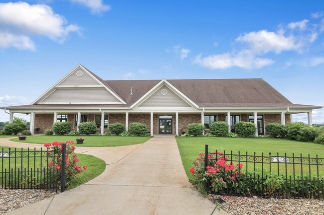
1201 S Benton Ctr Rd, Benton Harbor, MI 49022


NEARBY LISTINGS FOR SALE OR LEASE
Property Detail
1201 S Benton Ctr Rd
Niles-Benton Harbor, MI
BEG AT W1/4 PST SEC 26 T4S R18W TH S88DEG28'27''E 1243.7' TO WLY R/W US 31 TH N17DEG59'29''E ON R/W LN 119.78' TH N ON ARC OF 7366.44' RAD CUR LT 707.84' CHD BRG N03DEG46'10''E 707.56' TH N01DEG01'E 518.13' TH N88DEG28'27''W 1315.90' TO W SEC LN TH S
11-03-0026-0001-03-4
Berrien
Agriculturalland
Michigan
X
707
26021C0107C
40.01 AC
2024
Michigan Southwest Area
2025
Other Market Areas
002100
DEMOGRAPHICS near 1201 S Benton Ctr Rd
1 Mile
3 Mile
5 Mile
2024 Total Population
478
6,368
26,896
2029 Population
463
6,221
26,661
Pop Growth 2024-2029
(3.14%)
(2.31%)
(0.87%)
Average Age
42
39
38
2024 Total Households
190
2,476
10,504
HH Growth 2024-2029
(3.16%)
(2.67%)
(1.29%)
Median Household Inc
$55,294
$36,052
$31,693
Avg Household Size
2.40
2.40
2.40
2024 Avg HH Vehicles
2.00
2.00
1.00
Median Home Value
$178,947
$152,413
$135,868
Median Year Built
1963
1967
1963
Nearby Places
Map Layers
Map Styles
 Street
 Aerial
- Restaurants
- Banks
- Shops
- Fitness
- Groceries
PUBLIC TRANSPORTATION
COMMUTER RAIL
St. Joseph-Benton Harbor Amtrak Station (Pere Marquette - Amtrak)
DRIVE
WALK
Distance
St. Joseph-Benton Harbor Amtrak Station (Pere Marquette - Amtrak)
14 min
8.4 mi
AIRPORT
South Bend International
DRIVE
WALK
Distance
South Bend International
44 min
31.8 mi
Freight Ports
Port Milwaukee
DRIVE
WALK
Distance
Port Milwaukee
221 min
184.4 mi
SALE & LEASE HISTORY
LISTING DATE
SALE/LEASE

Sep 20, 2024
For Sale
Apr 04, 2025
For Sale
Nearby Properties
Address
Land Use
TOTAL SIZE
Lot Size
Zoning
Address
Land Use
TOTAL SIZE
Lot Size
Zoning
200,321 SF
15.47 AC
D1 COMM
Address
Land Use
TOTAL SIZE
Lot Size
Zoning
218,334 SF
25.05 AC
Address
Land Use
TOTAL SIZE
Lot Size
Zoning
66,680 SF
3.42 AC
Address
Land Use
TOTAL SIZE
Lot Size
Zoning
296,788 SF
34 AC
D1 COMM
Address
Land Use
TOTAL SIZE
Lot Size
Zoning
62,800 SF
3.06 AC
Address
Land Use
TOTAL SIZE
Lot Size
Zoning
171,165 SF
15.15 AC
D1 COMM
Address
Land Use
TOTAL SIZE
Lot Size
Zoning
112,503 SF
4.30 AC
C MULTI FA
Address
Land Use
TOTAL SIZE
Lot Size
Zoning
126,127 SF
11.84 AC
D1 COMM
Address
Land Use
TOTAL SIZE
Lot Size
Zoning
204,000 SF
34.08 AC
F HEAVY
Address
Land Use
TOTAL SIZE
Lot Size
Zoning
391,928 SF
40.84 AC
F HEAVY
Address
Land Use
TOTAL SIZE
Lot Size
Zoning
84,732 SF
4.19 AC
C MULTI FA
Address
Land Use
TOTAL SIZE
Lot Size
Zoning
77,703 SF
28.05 AC
F HEAVY
Address
Land Use
TOTAL SIZE
Lot Size
Zoning
88,572 SF
15.70 AC
D1 COMM
Address
Land Use
TOTAL SIZE
Lot Size
Zoning
254,984 SF
25.04 AC
R-A RE
Address
Land Use
TOTAL SIZE
Lot Size
Zoning
70,617 SF
12 AC
E RESTRICT
Address
Land Use
TOTAL SIZE
Lot Size
Zoning
60,188 SF
3.59 AC
D1 COMM
Address
Land Use
TOTAL SIZE
Lot Size
Zoning
23,923 SF
2.40 AC
D1 COMM
Address
Land Use
TOTAL SIZE
Lot Size
Zoning
1,590 SF
33.32 AC
C MULTI
Address
Land Use
TOTAL SIZE
Lot Size
Zoning
36,137 SF
21.40 AC
SPEC US
Address
Land Use
TOTAL SIZE
Lot Size
Zoning
32,066 SF
4.44 AC
Address
Land Use
TOTAL SIZE
Lot Size
Zoning
101,006 SF
2.42 AC
D1 COMM
Address
Land Use
TOTAL SIZE
Lot Size
Zoning
46,584 SF
12.19 AC
D1 COMM
Address
Land Use
TOTAL SIZE
Lot Size
Zoning
1,036 SF
34.40 AC
R-A RE
Address
Land Use
TOTAL SIZE
Lot Size
Zoning
126,880 SF
10 AC
D1 COMM
Address
Land Use
TOTAL SIZE
Lot Size
Zoning
41,412 SF
3.61 AC
D1 COMM
Address
Land Use
TOTAL SIZE
Lot Size
Zoning
23,767 SF
2.90 AC
D1 COMM
Address
Land Use
TOTAL SIZE
Lot Size
Zoning
13,500 SF
3.54 AC
E RESTRICT
Address
Land Use
TOTAL SIZE
Lot Size
Zoning
58,903 SF
DISTRICT A
Address
Land Use
TOTAL SIZE
Lot Size
Zoning
30,269 SF
3.97 AC
D1 COMM
Address
Land Use
TOTAL SIZE
Lot Size
Zoning
33,625 SF
5.09 AC
D1 COMM
The World's #1 Commercial Real Estate Marketplace
Connect with us
© 2025 CoStar Group
The information above has been obtained from sources believed reliable. While we do not doubt its accuracy we have not verified it and make no guarantee, warranty or representation about it. It is your responsibility to independently confirm its accuracy and completeness. Any projections, opinions, assumptions, or estimates used are for example only and do not represent the current or future performance of the property. The value of this transaction to you depends on tax and other factors which should be evaluated by your tax, financial, and legal advisors. You and your advisors should conduct a careful, independent investigation of the property to determine to your satisfaction the suitability of the property for your needs.