Property Record
1201 Network Centre Dr, Effingham, IL 62401
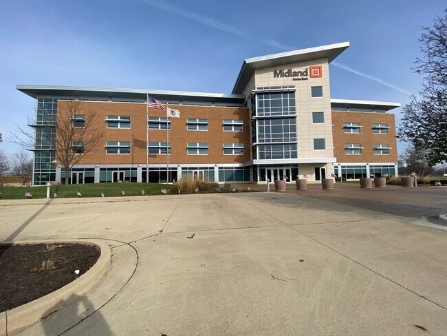

Property Detail
1201 Network Centre Dr
Effingham, IL
REPLAT OF LOT 1 NETWORK CENTRE SUB 2602/1 1110/84 857/117
0311016044
Effingham
Commercialnec
Illinois
B and X Area of moderate flood hazard, usually the area between the limits of the 100-year and 500-year floods.
1
2024
4.69 AC
2024
Effingham/Central Illinois Area
950600
Other Market Areas
68,674 SF
NEARBY LISTINGS FOR SALE OR LEASE
-
-
View all Effingham listings for lease on LoopNet.com
DEMOGRAPHICS near 1201 Network Centre Dr
1 mile
3 mile
5 mile
2025 Total Population
581
12,790
18,159
2030 Population
576
12,829
18,162
Pop Growth 2025-2030
(0.86%)
+ 0.30%
+ 0.02%
Average Age
42
41
41
2025 Total Households
248
5,526
7,659
HH Growth 2025-2030
(0.81%)
+ 0.27%
+ 0.03%
Median Household Inc
$108,750
$73,038
$72,583
Avg Household Size
2.30
2.20
2.30
2025 Avg HH Vehicles
2.00
2.00
2.00
Median Home Value
$225,352
$184,917
$195,678
Median Year Built
1984
1975
1976
Nearby Places
Map Layers
Map Styles
 Street
 Aerial
Transit
 Traffic
 Biking
Places
Listings with unknown addresses are not visible on the map
- Restaurants
- Banks
- Shops
- Fitness
- Groceries
PUBLIC TRANSPORTATION
COMMUTER RAIL
Effingham Amtrak Station (City of New Orleans - Amtrak, Illini - Amtrak, Saluki - Amtrak)
Drive
Walk
Distance
Effingham Amtrak Station (City of New Orleans - Amtrak, Illini - Amtrak, Saluki - Amtrak)
6 min
3.0 mi
Freight Ports
Port Milwaukee
Drive
Walk
Distance
Port Milwaukee
336 min
294.3 mi
SALE & LEASE HISTORY
LISTING DATE
SALE/LEASE

Feb 28, 2023
For Lease
Nearby Properties
Address
Land Use
TOTAL SIZE
Lot Size
Zoning
Address
Land Use
TOTAL SIZE
Lot Size
Zoning
1,241,292 SF
71.55 AC
Address
Land Use
TOTAL SIZE
Lot Size
Zoning
66,544 SF
5.07 AC
Address
Land Use
TOTAL SIZE
Lot Size
Zoning
224,208 SF
19.77 AC
Address
Land Use
TOTAL SIZE
Lot Size
Zoning
19,177 SF
4.25 AC
Address
Land Use
TOTAL SIZE
Lot Size
Zoning
65,800 SF
8.43 AC
Address
Land Use
TOTAL SIZE
Lot Size
Zoning
23,312 SF
14.48 AC
Address
Land Use
TOTAL SIZE
Lot Size
Zoning
80,075 SF
3.26 AC
Address
Land Use
TOTAL SIZE
Lot Size
Zoning
224,578 SF
20.96 AC
Address
Land Use
TOTAL SIZE
Lot Size
Zoning
65,712 SF
2.36 AC
Address
Land Use
TOTAL SIZE
Lot Size
Zoning
15,637 SF
2.19 AC
Address
Land Use
TOTAL SIZE
Lot Size
Zoning
37,248 SF
6.72 AC
Address
Land Use
TOTAL SIZE
Lot Size
Zoning
56,333 SF
6.20 AC
Address
Land Use
TOTAL SIZE
Lot Size
Zoning
56,553 SF
7.13 AC
Address
Land Use
TOTAL SIZE
Lot Size
Zoning
31,577 SF
6.44 AC
Address
Land Use
TOTAL SIZE
Lot Size
Zoning
41,734 SF
2.77 AC
Address
Land Use
TOTAL SIZE
Lot Size
Zoning
52,260 SF
2.20 AC
Address
Land Use
TOTAL SIZE
Lot Size
Zoning
42,439 SF
6.29 AC
Address
Land Use
TOTAL SIZE
Lot Size
Zoning
17,611 SF
15.97 AC
Address
Land Use
TOTAL SIZE
Lot Size
Zoning
426,281 SF
19.55 AC
Address
Land Use
TOTAL SIZE
Lot Size
Zoning
18,290 SF
1.85 AC
Address
Land Use
TOTAL SIZE
Lot Size
Zoning
47,835 SF
4.84 AC
Address
Land Use
TOTAL SIZE
Lot Size
Zoning
41,785 SF
11.20 AC
Address
Land Use
TOTAL SIZE
Lot Size
Zoning
49,524 SF
4.13 AC
Address
Land Use
TOTAL SIZE
Lot Size
Zoning
213,880 SF
45.80 AC
Address
Land Use
TOTAL SIZE
Lot Size
Zoning
20,328 SF
2.65 AC
Address
Land Use
TOTAL SIZE
Lot Size
Zoning
49,376 SF
15.51 AC
Address
Land Use
TOTAL SIZE
Lot Size
Zoning
33,800 SF
6.86 AC
Address
Land Use
TOTAL SIZE
Lot Size
Zoning
58,621 SF
5.02 AC
Address
Land Use
TOTAL SIZE
Lot Size
Zoning
439,686 SF
26.41 AC
The World's #1 Commercial Real Estate Marketplace
Connect with us
© 2026 CoStar Group
The information above has been obtained from sources believed reliable. While we do not doubt its accuracy we have not verified it and make no guarantee, warranty or representation about it. It is your responsibility to independently confirm its accuracy and completeness. Any projections, opinions, assumptions, or estimates used are for example only and do not represent the current or future performance of the property. The value of this transaction to you depends on tax and other factors which should be evaluated by your tax, financial, and legal advisors. You and your advisors should conduct a careful, independent investigation of the property to determine to your satisfaction the suitability of the property for your needs.