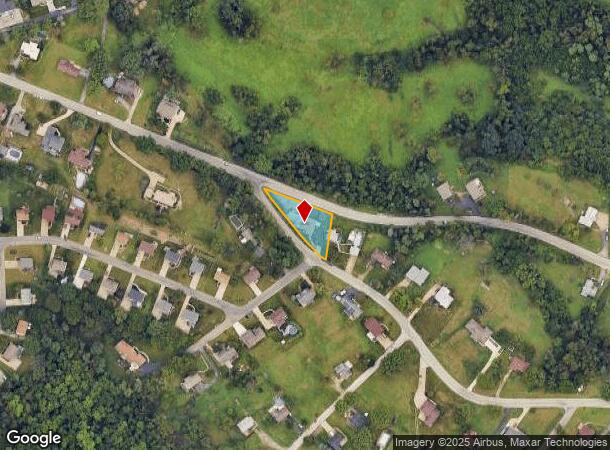
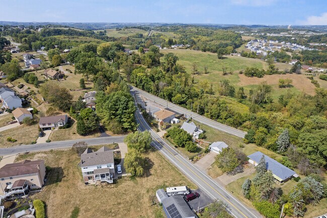
Property Record
1201 Oakridge Rd, Mc Donald, PA 15057
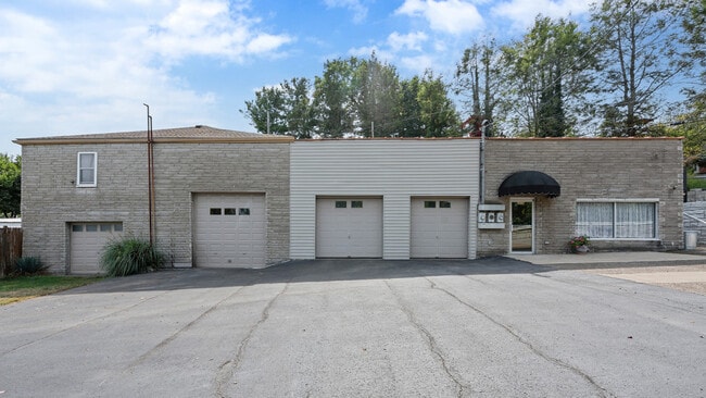
This Property Is For Sale
NEARBY LISTINGS FOR SALE OR LEASE
-
-
View all Mc Donald listings for sale on LoopNet.com
Property Detail
1201 Oakridge Rd
Pittsburgh, PA
Hormel Ethel Plan
0328-K-00005-0000-00
HORMEL ETHEL PLAN #10 IRREG LOT 300X201.60X 376.36 OAKDALE RD 1 STY STN-FAC HSE-ATT-GARS #4499
Retailwithmorethanonenonretailuse
Allegheny
X
Pennsylvania
42003C0318H
5
2024
0.69 AC
2025
South Pittsburgh
456001
Pittsburgh
DEMOGRAPHICS near 1201 Oakridge Rd
1 Mile
3 Mile
5 Mile
2024 Total Population
2,873
20,279
83,150
2029 Population
2,854
20,059
82,379
Pop Growth 2024-2029
(0.66%)
(1.08%)
(0.93%)
Average Age
39
41
43
2024 Total Households
990
7,648
34,722
HH Growth 2024-2029
(0.61%)
(1.20%)
(1.04%)
Median Household Inc
$145,926
$127,363
$98,000
Avg Household Size
2.90
2.60
2.30
2024 Avg HH Vehicles
2.00
2.00
2.00
Median Home Value
$411,981
$376,726
$288,703
Median Year Built
1998
1992
1970
Nearby Places
- Restaurants
- Banks
- Shops
- Fitness
- Groceries
PUBLIC TRANSPORTATION
AIRPORT
Pittsburgh International
DRIVE
WALK
Distance
Pittsburgh International
22 min
13.6 mi
Freight Ports
Port of Toledo
DRIVE
WALK
Distance
Port of Toledo
266 min
233.3 mi
Nearby Properties
Address
Land Use
TOTAL SIZE
Lot Size
Zoning
Address
Land Use
TOTAL SIZE
Lot Size
Zoning
125.59 AC
Address
Land Use
TOTAL SIZE
Lot Size
Zoning
21.38 AC
Address
Land Use
TOTAL SIZE
Lot Size
Zoning
Address
Land Use
TOTAL SIZE
Lot Size
Zoning
Address
Land Use
TOTAL SIZE
Lot Size
Zoning
Address
Land Use
TOTAL SIZE
Lot Size
Zoning
15.53 AC
Address
Land Use
TOTAL SIZE
Lot Size
Zoning
71.84 AC
Address
Land Use
TOTAL SIZE
Lot Size
Zoning
Address
Land Use
TOTAL SIZE
Lot Size
Zoning
12.34 AC
Address
Land Use
TOTAL SIZE
Lot Size
Zoning
Address
Land Use
TOTAL SIZE
Lot Size
Zoning
6.76 AC
Address
Land Use
TOTAL SIZE
Lot Size
Zoning
Address
Land Use
TOTAL SIZE
Lot Size
Zoning
16.30 AC
Address
Land Use
TOTAL SIZE
Lot Size
Zoning
Address
Land Use
TOTAL SIZE
Lot Size
Zoning
7.28 AC
Address
Land Use
TOTAL SIZE
Lot Size
Zoning
Address
Land Use
TOTAL SIZE
Lot Size
Zoning
31.63 AC
Address
Land Use
TOTAL SIZE
Lot Size
Zoning
Address
Land Use
TOTAL SIZE
Lot Size
Zoning
Address
Land Use
TOTAL SIZE
Lot Size
Zoning
Address
Land Use
TOTAL SIZE
Lot Size
Zoning
Address
Land Use
TOTAL SIZE
Lot Size
Zoning
Address
Land Use
TOTAL SIZE
Lot Size
Zoning
1.72 AC
Address
Land Use
TOTAL SIZE
Lot Size
Zoning
11,856 SF
10.37 AC
Address
Land Use
TOTAL SIZE
Lot Size
Zoning
1.15 AC
Address
Land Use
TOTAL SIZE
Lot Size
Zoning
7.51 AC
Address
Land Use
TOTAL SIZE
Lot Size
Zoning
5.20 AC
Address
Land Use
TOTAL SIZE
Lot Size
Zoning
Address
Land Use
TOTAL SIZE
Lot Size
Zoning
Address
Land Use
TOTAL SIZE
Lot Size
Zoning
6.09 AC
The World's #1 Commercial Real Estate Marketplace
Connect with us
© 2025 CoStar Group
The information above has been obtained from sources believed reliable. While we do not doubt its accuracy we have not verified it and make no guarantee, warranty or representation about it. It is your responsibility to independently confirm its accuracy and completeness. Any projections, opinions, assumptions, or estimates used are for example only and do not represent the current or future performance of the property. The value of this transaction to you depends on tax and other factors which should be evaluated by your tax, financial, and legal advisors. You and your advisors should conduct a careful, independent investigation of the property to determine to your satisfaction the suitability of the property for your needs.