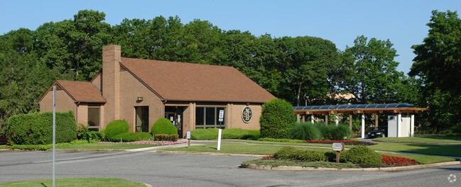
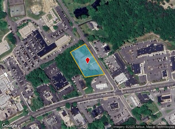
Property Record
1201 Ostrander Ave, Riverhead, NY 11901
NEARBY LISTINGS FOR SALE OR LEASE
Property Detail
1201 Ostrander Ave
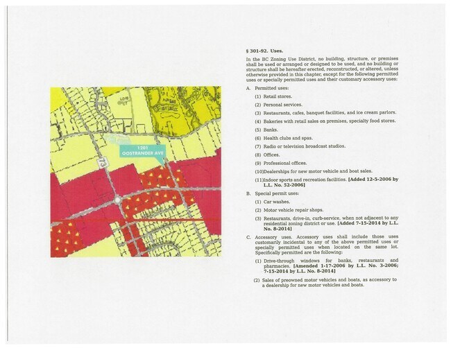
0600-082-00-03-00-007-000
LTS 61-63 PT LTS 59 & 60 1231 OSTRANDER HTS BLK A
Financialbuilding
Suffolk
X
New York
36103C0466H
7
2024
1.50 AC
2024
Eastern Suffolk
169903
Long Island (New York)
2,305 SF
Nassau County-Suffolk County, NY
DEMOGRAPHICS near 1201 Ostrander Ave
1 Mile
3 Mile
5 Mile
2024 Total Population
6,825
25,004
36,548
2029 Population
6,786
24,826
36,431
Pop Growth 2024-2029
(0.57%)
(0.71%)
(0.32%)
Average Age
45
42
43
2024 Total Households
2,605
9,098
13,381
HH Growth 2024-2029
(0.65%)
(0.97%)
(0.49%)
Median Household Inc
$63,333
$65,469
$73,540
Avg Household Size
2.50
2.60
2.60
2024 Avg HH Vehicles
2.00
2.00
2.00
Median Home Value
$436,792
$386,786
$427,978
Median Year Built
1996
1983
1983
Nearby Places
- Restaurants
- Banks
- Shops
- Fitness
- Groceries
PUBLIC TRANSPORTATION
COMMUTER RAIL
Riverhead Station (Greenport Branch - Long Island Rail Road)
DRIVE
WALK
Distance
Riverhead Station (Greenport Branch - Long Island Rail Road)
4 min
1.5 mi
Westhampton Station (Montauk Branch - Long Island Rail Road)
DRIVE
WALK
Distance
Westhampton Station (Montauk Branch - Long Island Rail Road)
15 min
8.2 mi
AIRPORT
Long Island MacArthur
DRIVE
WALK
Distance
Long Island MacArthur
47 min
28.5 mi
SALE & LEASE HISTORY
LISTING DATE
SALE/LEASE

Oct 15, 2020
For Sale
Feb 25, 2020
For Lease
Aug 08, 2018
For Sale
Apr 09, 2018
For Sale
Nearby Properties
Address
Land Use
TOTAL SIZE
Lot Size
Zoning
Address
Land Use
TOTAL SIZE
Lot Size
Zoning
233,668 SF
82.70 AC
CR200
Address
Land Use
TOTAL SIZE
Lot Size
Zoning
450,000 SF
8.50 AC
3
Address
Land Use
TOTAL SIZE
Lot Size
Zoning
252,053 SF
31.60 AC
3
Address
Land Use
TOTAL SIZE
Lot Size
Zoning
42.70 AC
9
Address
Land Use
TOTAL SIZE
Lot Size
Zoning
49,680 SF
1.30 AC
8
Address
Land Use
TOTAL SIZE
Lot Size
Zoning
176,704 SF
34.70 AC
3
Address
Land Use
TOTAL SIZE
Lot Size
Zoning
51.70 AC
R15
Address
Land Use
TOTAL SIZE
Lot Size
Zoning
47.30 AC
9
Address
Land Use
TOTAL SIZE
Lot Size
Zoning
8,100 SF
4.31 AC
LI40
Address
Land Use
TOTAL SIZE
Lot Size
Zoning
127,334 SF
49.72 AC
04
Address
Land Use
TOTAL SIZE
Lot Size
Zoning
17 AC
CR200
Address
Land Use
TOTAL SIZE
Lot Size
Zoning
151,290 SF
6.17 AC
08
Address
Land Use
TOTAL SIZE
Lot Size
Zoning
81.70 AC
R60
Address
Land Use
TOTAL SIZE
Lot Size
Zoning
36,883 SF
14.80 AC
R15
Address
Land Use
TOTAL SIZE
Lot Size
Zoning
23,743 SF
5.80 AC
MTL
Address
Land Use
TOTAL SIZE
Lot Size
Zoning
25,620 SF
7.03 AC
9
Address
Land Use
TOTAL SIZE
Lot Size
Zoning
13.92 AC
04
Address
Land Use
TOTAL SIZE
Lot Size
Zoning
16,699 SF
24.81 AC
03
Address
Land Use
TOTAL SIZE
Lot Size
Zoning
20.72 AC
09
Address
Land Use
TOTAL SIZE
Lot Size
Zoning
29.72 AC
R20
Address
Land Use
TOTAL SIZE
Lot Size
Zoning
68.90 AC
H2O
Address
Land Use
TOTAL SIZE
Lot Size
Zoning
26.39 AC
04
Address
Land Use
TOTAL SIZE
Lot Size
Zoning
108,572 SF
17.30 AC
04
Address
Land Use
TOTAL SIZE
Lot Size
Zoning
13,773 SF
11.65 AC
03
Address
Land Use
TOTAL SIZE
Lot Size
Zoning
36.60 AC
RC
Address
Land Use
TOTAL SIZE
Lot Size
Zoning
108,504 SF
31.20 AC
SC
Address
Land Use
TOTAL SIZE
Lot Size
Zoning
1,435 SF
13.20 AC
Address
Land Use
TOTAL SIZE
Lot Size
Zoning
4,410 SF
1 AC
OD
Address
Land Use
TOTAL SIZE
Lot Size
Zoning
113,634 SF
27.49 AC
04
Address
Land Use
TOTAL SIZE
Lot Size
Zoning
15,819 SF
1.08 AC
HB
The World's #1 Commercial Real Estate Marketplace
Connect with us
© 2025 CoStar Group
The information above has been obtained from sources believed reliable. While we do not doubt its accuracy we have not verified it and make no guarantee, warranty or representation about it. It is your responsibility to independently confirm its accuracy and completeness. Any projections, opinions, assumptions, or estimates used are for example only and do not represent the current or future performance of the property. The value of this transaction to you depends on tax and other factors which should be evaluated by your tax, financial, and legal advisors. You and your advisors should conduct a careful, independent investigation of the property to determine to your satisfaction the suitability of the property for your needs.