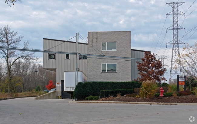
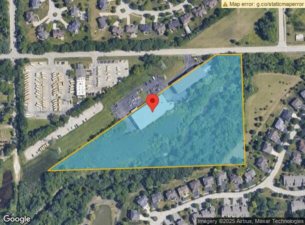
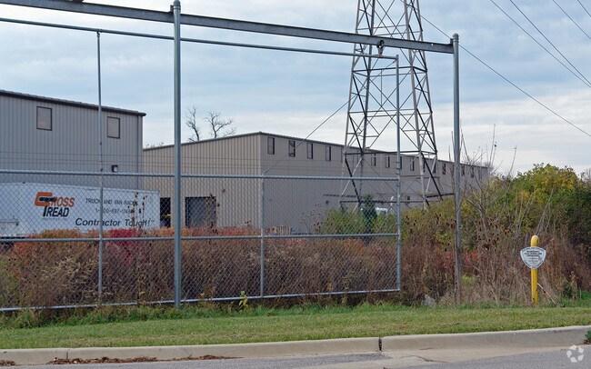
Property Record
12011 91St St, Willow Springs, IL 60480
NEARBY LISTINGS FOR SALE OR LEASE
Property Detail
12011 91St St
Chicago-Naperville-Elgin, IL-IN
H Harringtons Sub Of N Of Des Plaines
23-06-300-006-0000
N2NW4SW4 S06 T37N R12E 3P
Industrialgeneral
Cook
AE
Illinois
17043C0281J
7,8
2023
9.76 AC
2025
South I-55 Corridor
820203
Chicago
51,986 SF
DEMOGRAPHICS near 12011 91St St
1 Mile
3 Mile
5 Mile
2024 Total Population
2,485
27,220
136,759
2029 Population
2,388
26,754
134,112
Pop Growth 2024-2029
(3.90%)
(1.71%)
(1.94%)
Average Age
46
44
43
2024 Total Households
890
10,776
53,840
HH Growth 2024-2029
(4.27%)
(1.87%)
(2.15%)
Median Household Inc
$146,397
$104,491
$89,870
Avg Household Size
2.80
2.50
2.50
2024 Avg HH Vehicles
2.00
2.00
2.00
Median Home Value
$717,370
$447,495
$352,718
Median Year Built
1984
1980
1977
Nearby Places
Map Layers
Map Styles
 Street
 Aerial
- Restaurants
- Banks
- Shops
- Fitness
- Groceries
PUBLIC TRANSPORTATION
COMMUTER RAIL
Willow Springs Station (Heritage Corridor Line - Northeast Illinois Regional Commuter Railroad (Metra))
DRIVE
WALK
Distance
Willow Springs Station (Heritage Corridor Line - Northeast Illinois Regional Commuter Railroad (Metra))
9 min
3.2 mi
Highlands Station (Burlington Northern-Santa Fe Railway Line - Northeast Illinois Regional Commuter Railroad (Metra))
DRIVE
WALK
Distance
Highlands Station (Burlington Northern-Santa Fe Railway Line - Northeast Illinois Regional Commuter Railroad (Metra))
15 min
6.3 mi
AIRPORT
Chicago Midway International
DRIVE
WALK
Distance
Chicago Midway International
23 min
11.0 mi
Chicago O'Hare International
DRIVE
WALK
Distance
Chicago O'Hare International
52 min
24.1 mi
Nearby Properties
Address
Land Use
TOTAL SIZE
Lot Size
Zoning
Address
Land Use
TOTAL SIZE
Lot Size
Zoning
96.60 AC
Address
Land Use
TOTAL SIZE
Lot Size
Zoning
183,080 SF
20.86 AC
C
Address
Land Use
TOTAL SIZE
Lot Size
Zoning
204,824 SF
15.05 AC
Address
Land Use
TOTAL SIZE
Lot Size
Zoning
68.06 AC
Address
Land Use
TOTAL SIZE
Lot Size
Zoning
436,456 SF
59.11 AC
I
Address
Land Use
TOTAL SIZE
Lot Size
Zoning
104,912 SF
6.91 AC
Address
Land Use
TOTAL SIZE
Lot Size
Zoning
289,314 SF
2.79 AC
Address
Land Use
TOTAL SIZE
Lot Size
Zoning
94,064 SF
8.55 AC
Address
Land Use
TOTAL SIZE
Lot Size
Zoning
110,584 SF
5.57 AC
Address
Land Use
TOTAL SIZE
Lot Size
Zoning
195,000 SF
10.18 AC
Address
Land Use
TOTAL SIZE
Lot Size
Zoning
215,631 SF
23.94 AC
I
Address
Land Use
TOTAL SIZE
Lot Size
Zoning
128,283 SF
6.89 AC
C
Address
Land Use
TOTAL SIZE
Lot Size
Zoning
52,887 SF
4.64 AC
C
Address
Land Use
TOTAL SIZE
Lot Size
Zoning
144,840 SF
3.42 AC
Address
Land Use
TOTAL SIZE
Lot Size
Zoning
Address
Land Use
TOTAL SIZE
Lot Size
Zoning
153,000 SF
10.26 AC
Address
Land Use
TOTAL SIZE
Lot Size
Zoning
134,235 SF
7.96 AC
Address
Land Use
TOTAL SIZE
Lot Size
Zoning
105,562 SF
9.64 AC
Address
Land Use
TOTAL SIZE
Lot Size
Zoning
96,758 SF
6.89 AC
Address
Land Use
TOTAL SIZE
Lot Size
Zoning
79,232 SF
3.19 AC
C
Address
Land Use
TOTAL SIZE
Lot Size
Zoning
61,481 SF
3.99 AC
Address
Land Use
TOTAL SIZE
Lot Size
Zoning
14,400 SF
0.80 AC
Address
Land Use
TOTAL SIZE
Lot Size
Zoning
76,701 SF
5.02 AC
C
Address
Land Use
TOTAL SIZE
Lot Size
Zoning
136,618 SF
19.66 AC
I
Address
Land Use
TOTAL SIZE
Lot Size
Zoning
41,600 SF
3.66 AC
C
Address
Land Use
TOTAL SIZE
Lot Size
Zoning
45,684 SF
4.24 AC
C
Address
Land Use
TOTAL SIZE
Lot Size
Zoning
63,231 SF
2.53 AC
Address
Land Use
TOTAL SIZE
Lot Size
Zoning
54,000 SF
5.22 AC
I
Address
Land Use
TOTAL SIZE
Lot Size
Zoning
2,056,254 SF
22.98 AC
Address
Land Use
TOTAL SIZE
Lot Size
Zoning
49,971 SF
3.80 AC
The World's #1 Commercial Real Estate Marketplace
Connect with us
© 2026 CoStar Group
The information above has been obtained from sources believed reliable. While we do not doubt its accuracy we have not verified it and make no guarantee, warranty or representation about it. It is your responsibility to independently confirm its accuracy and completeness. Any projections, opinions, assumptions, or estimates used are for example only and do not represent the current or future performance of the property. The value of this transaction to you depends on tax and other factors which should be evaluated by your tax, financial, and legal advisors. You and your advisors should conduct a careful, independent investigation of the property to determine to your satisfaction the suitability of the property for your needs.