Property Record
12012 Blue Ridge Ext, Grandview, MO 64030


Property Detail
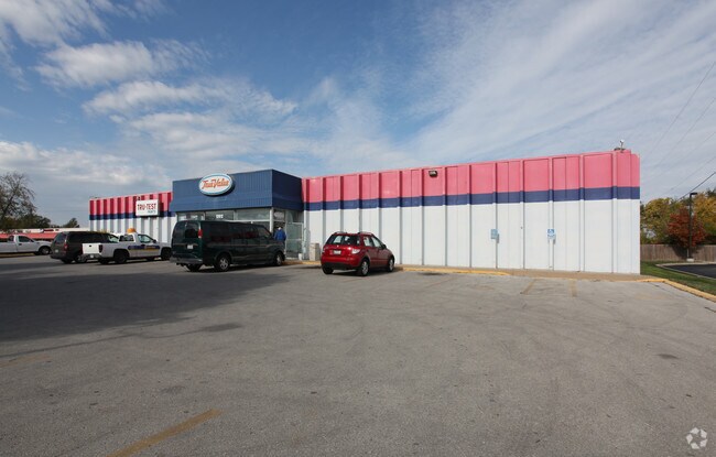
12012 Blue Ridge Ext
64-500-04-58-01-0-00-000
RNG-33 TWP-47 SEC-11 PT NE 1/4 SE 1/4 DAF: BEG AT TH INTERSE C OF TH W ROW LI US HWY 71 & TH NWLY ROW BLUE RIDGE BLVD EXT TH S 45 DEG W ALG SD NWLY ROW BLUE RIDGE BLVD EXT 950 TO T
Storebuilding
Jackson
B and X Area of moderate flood hazard, usually the area between the limits of the 100-year and 500-year floods.
Missouri
2024
1.94 AC
2025
South Kansas City MO
013301
Kansas City
21,291 SF
Kansas City, MO-KS
NEARBY LISTINGS FOR SALE OR LEASE
DEMOGRAPHICS near 12012 Blue Ridge Ext
1 mile
3 mile
5 mile
2025 Total Population
7,448
49,776
109,721
2030 Population
7,545
50,180
110,926
Pop Growth 2025-2030
+ 1.30%
+ 0.81%
+ 1.10%
Average Age
38
38
39
2025 Total Households
3,428
19,934
45,757
HH Growth 2025-2030
+ 1.23%
+ 0.79%
+ 1.06%
Median Household Inc
$39,927
$57,607
$62,157
Avg Household Size
2.10
2.40
2.30
2025 Avg HH Vehicles
1.00
2.00
2.00
Median Home Value
$177,937
$169,486
$219,222
Median Year Built
1974
1968
1972
Nearby Places
Map Layers
Map Styles
 Street
 Aerial
Layers
 Traffic
 Biking
Places
Listings with unknown addresses are not visible on the map
- Restaurants
- Banks
- Shops
- Fitness
- Groceries
PUBLIC TRANSPORTATION
AIRPORT
Kansas City International
Drive
Walk
Distance
Kansas City International
48 min
34.7 mi
Nearby Properties
Address
Land Use
TOTAL SIZE
Lot Size
Zoning
Address
Land Use
TOTAL SIZE
Lot Size
Zoning
547,629 SF
62.41 AC
Address
Land Use
TOTAL SIZE
Lot Size
Zoning
270,862 SF
27.39 AC
Address
Land Use
TOTAL SIZE
Lot Size
Zoning
89,709 SF
13.43 AC
Address
Land Use
TOTAL SIZE
Lot Size
Zoning
875,807 SF
49.32 AC
Address
Land Use
TOTAL SIZE
Lot Size
Zoning
61,903 SF
54.40 AC
Address
Land Use
TOTAL SIZE
Lot Size
Zoning
504,100 SF
39.25 AC
Address
Land Use
TOTAL SIZE
Lot Size
Zoning
628,134 SF
37.62 AC
Address
Land Use
TOTAL SIZE
Lot Size
Zoning
180,271 SF
21.60 AC
Address
Land Use
TOTAL SIZE
Lot Size
Zoning
35,850 SF
41.30 AC
Address
Land Use
TOTAL SIZE
Lot Size
Zoning
94,080 SF
5.83 AC
Address
Land Use
TOTAL SIZE
Lot Size
Zoning
315,314 SF
37.40 AC
Address
Land Use
TOTAL SIZE
Lot Size
Zoning
46,317 SF
9.63 AC
Address
Land Use
TOTAL SIZE
Lot Size
Zoning
253,575 SF
43.62 AC
Address
Land Use
TOTAL SIZE
Lot Size
Zoning
485,993 SF
22.35 AC
Address
Land Use
TOTAL SIZE
Lot Size
Zoning
94,123 SF
37.36 AC
Address
Land Use
TOTAL SIZE
Lot Size
Zoning
441,586 SF
45.68 AC
Address
Land Use
TOTAL SIZE
Lot Size
Zoning
23,257 SF
11.04 AC
Address
Land Use
TOTAL SIZE
Lot Size
Zoning
13,088 SF
25.27 AC
Address
Land Use
TOTAL SIZE
Lot Size
Zoning
23,164 SF
23.60 AC
Address
Land Use
TOTAL SIZE
Lot Size
Zoning
587,871 SF
57.57 AC
Address
Land Use
TOTAL SIZE
Lot Size
Zoning
84,968 SF
9.51 AC
Address
Land Use
TOTAL SIZE
Lot Size
Zoning
128,111 SF
0.32 AC
Address
Land Use
TOTAL SIZE
Lot Size
Zoning
88,800 SF
4.70 AC
Address
Land Use
TOTAL SIZE
Lot Size
Zoning
96,074 SF
9.40 AC
Address
Land Use
TOTAL SIZE
Lot Size
Zoning
104,430 SF
9.86 AC
Address
Land Use
TOTAL SIZE
Lot Size
Zoning
374.20 AC
Address
Land Use
TOTAL SIZE
Lot Size
Zoning
93,747 SF
Address
Land Use
TOTAL SIZE
Lot Size
Zoning
124,785 SF
20 AC
Address
Land Use
TOTAL SIZE
Lot Size
Zoning
241,237 SF
8.52 AC
Address
Land Use
TOTAL SIZE
Lot Size
Zoning
87,367 SF
15.41 AC
The World's #1 Commercial Real Estate Marketplace
Connect with us
© 2026 CoStar Group
The information above has been obtained from sources believed reliable. While we do not doubt its accuracy we have not verified it and make no guarantee, warranty or representation about it. It is your responsibility to independently confirm its accuracy and completeness. Any projections, opinions, assumptions, or estimates used are for example only and do not represent the current or future performance of the property. The value of this transaction to you depends on tax and other factors which should be evaluated by your tax, financial, and legal advisors. You and your advisors should conduct a careful, independent investigation of the property to determine to your satisfaction the suitability of the property for your needs.