Property Record
12016 Hanover Courthouse Rd, Hanover, VA 23069

NEARBY LISTINGS FOR SALE OR LEASE
-
-
View all Hanover listings for lease on LoopNet.com
Property Detail
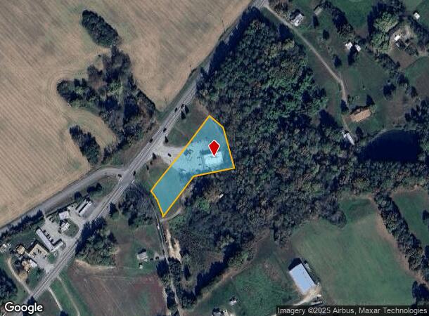
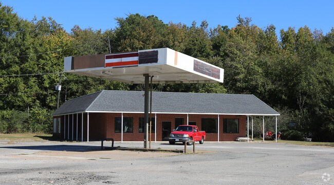
12016 Hanover Courthouse Rd
8719-10-3104
HWY 301 PT ELMORE G CROS S
Commercialnec
Hanover
X
Virginia
51085C0330C
1.33 AC
2025
I-95 Chamberlayne/NE
2025
Richmond VA
320702
Richmond, VA
4,080 SF
DEMOGRAPHICS near 12016 Hanover Courthouse Rd
1 Mile
3 Mile
5 Mile
2024 Total Population
739
4,810
26,477
2029 Population
796
5,158
28,191
Pop Growth 2024-2029
+ 7.71%
+ 7.23%
+ 6.47%
Average Age
41
42
40
2024 Total Households
247
1,674
9,293
HH Growth 2024-2029
+ 7.69%
+ 7.41%
+ 6.61%
Median Household Inc
$138,043
$124,207
$129,358
Avg Household Size
2.80
2.70
2.80
2024 Avg HH Vehicles
3.00
3.00
2.00
Median Home Value
$461,475
$417,220
$367,442
Median Year Built
1992
1988
1993
Nearby Places
Map Layers
Map Styles
 Street
 Aerial
- Restaurants
- Banks
- Shops
- Fitness
- Groceries
PUBLIC TRANSPORTATION
COMMUTER RAIL
DRIVE
WALK
Distance
16 min
9.8 mi
AIRPORT
Richmond International
DRIVE
WALK
Distance
Richmond International
31 min
19.9 mi
Freight Ports
Virginia Port Authority - Richmond
DRIVE
WALK
Distance
Virginia Port Authority - Richmond
36 min
23.3 mi
SALE & LEASE HISTORY
LISTING DATE
SALE/LEASE

Sep 25, 2016
For Lease
Nov 19, 2018
For Lease
Nearby Properties
Address
Land Use
TOTAL SIZE
Lot Size
Zoning
Address
Land Use
TOTAL SIZE
Lot Size
Zoning
95.24 AC
A-1
Address
Land Use
TOTAL SIZE
Lot Size
Zoning
105,471 SF
34.80 AC
A-1
Address
Land Use
TOTAL SIZE
Lot Size
Zoning
34.69 AC
A-1
Address
Land Use
TOTAL SIZE
Lot Size
Zoning
93,198 SF
18.88 AC
B-3
Address
Land Use
TOTAL SIZE
Lot Size
Zoning
1,741.33 AC
A-1
Address
Land Use
TOTAL SIZE
Lot Size
Zoning
37,136 SF
85.22 AC
B-O
Address
Land Use
TOTAL SIZE
Lot Size
Zoning
43,096 SF
5.77 AC
A-1
Address
Land Use
TOTAL SIZE
Lot Size
Zoning
18,723 SF
3.93 AC
B-O
Address
Land Use
TOTAL SIZE
Lot Size
Zoning
143.77 AC
A-1
Address
Land Use
TOTAL SIZE
Lot Size
Zoning
19,175 SF
327.74 AC
A-1
Address
Land Use
TOTAL SIZE
Lot Size
Zoning
36,074 SF
2.39 AC
A-1
Address
Land Use
TOTAL SIZE
Lot Size
Zoning
13,464 SF
3.01 AC
A-1
Address
Land Use
TOTAL SIZE
Lot Size
Zoning
47,520 SF
4.99 AC
B-3
Address
Land Use
TOTAL SIZE
Lot Size
Zoning
21,829 SF
3.22 AC
B-O
Address
Land Use
TOTAL SIZE
Lot Size
Zoning
467.69 AC
A-1
Address
Land Use
TOTAL SIZE
Lot Size
Zoning
2.74 AC
M-1
Address
Land Use
TOTAL SIZE
Lot Size
Zoning
12,388 SF
3.55 AC
B-3
Address
Land Use
TOTAL SIZE
Lot Size
Zoning
5.88 AC
A-1
Address
Land Use
TOTAL SIZE
Lot Size
Zoning
5.42 AC
A-1
Address
Land Use
TOTAL SIZE
Lot Size
Zoning
10,633 SF
5.75 AC
A-1
Address
Land Use
TOTAL SIZE
Lot Size
Zoning
12,960 SF
3.09 AC
B-3
Address
Land Use
TOTAL SIZE
Lot Size
Zoning
20,650 SF
2.08 AC
A-1
Address
Land Use
TOTAL SIZE
Lot Size
Zoning
3,200 SF
31.73 AC
A-1
Address
Land Use
TOTAL SIZE
Lot Size
Zoning
9,100 SF
2 AC
B-3
Address
Land Use
TOTAL SIZE
Lot Size
Zoning
142.83 AC
A-1
Address
Land Use
TOTAL SIZE
Lot Size
Zoning
212.45 AC
A-1
Address
Land Use
TOTAL SIZE
Lot Size
Zoning
6,000 SF
0.74 AC
B-3
Address
Land Use
TOTAL SIZE
Lot Size
Zoning
1,105 SF
35.91 AC
A-1
Address
Land Use
TOTAL SIZE
Lot Size
Zoning
5 AC
A-1
Address
Land Use
TOTAL SIZE
Lot Size
Zoning
0.23 AC
A-1
The World's #1 Commercial Real Estate Marketplace
Connect with us
© 2025 CoStar Group
The information above has been obtained from sources believed reliable. While we do not doubt its accuracy we have not verified it and make no guarantee, warranty or representation about it. It is your responsibility to independently confirm its accuracy and completeness. Any projections, opinions, assumptions, or estimates used are for example only and do not represent the current or future performance of the property. The value of this transaction to you depends on tax and other factors which should be evaluated by your tax, financial, and legal advisors. You and your advisors should conduct a careful, independent investigation of the property to determine to your satisfaction the suitability of the property for your needs.