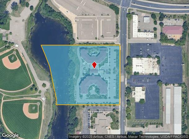
Property Record
12016 Ulysses St Ne, Minneapolis, MN 55434
NEARBY LISTINGS FOR SALE OR LEASE
Property Detail
12016 Ulysses St Ne
Minneapolis-St. Paul-Bloomington, MN-WI
Blaine Commons
08-31-23-31-0021
SLY 80 FT OF LOT 3 TOG/W LOTS 4 & 5 BLOCK 1 BLAINE COMMONS
Apartment
Anoka
A
Minnesota
27003C0328E
3-5
2024
7.60 AC
2025
Suburban St Paul
050824
Minneapolis/St Paul
76,383 SF
DEMOGRAPHICS near 12016 Ulysses St Ne
1 Mile
3 Mile
5 Mile
2024 Total Population
11,814
71,039
151,813
2029 Population
12,262
74,011
158,012
Pop Growth 2024-2029
+ 3.79%
+ 4.18%
+ 4.08%
Average Age
39
39
39
2024 Total Households
4,318
25,317
55,029
HH Growth 2024-2029
+ 3.77%
+ 4.14%
+ 4.05%
Median Household Inc
$99,775
$97,303
$91,208
Avg Household Size
2.70
2.70
2.70
2024 Avg HH Vehicles
2.00
2.00
2.00
Median Home Value
$279,095
$294,514
$286,105
Median Year Built
1991
1991
1988
Nearby Places
Map Layers
Map Styles
 Street
 Aerial
- Restaurants
- Banks
- Shops
- Fitness
- Groceries
PUBLIC TRANSPORTATION
COMMUTER RAIL
Coon Rapids-Riverdale Station (Northstar Corridor - Northstar Commuter Rail)
DRIVE
WALK
Distance
Coon Rapids-Riverdale Station (Northstar Corridor - Northstar Commuter Rail)
14 min
6.5 mi
Anoka Station (Northstar Corridor - Northstar Commuter Rail)
DRIVE
WALK
Distance
Anoka Station (Northstar Corridor - Northstar Commuter Rail)
16 min
8.2 mi
AIRPORT
Minneapolis-St Paul International/Wold-Chamberlain
DRIVE
WALK
Distance
Minneapolis-St Paul International/Wold-Chamberlain
44 min
30.1 mi
Nearby Properties
Address
Land Use
TOTAL SIZE
Lot Size
Zoning
Address
Land Use
TOTAL SIZE
Lot Size
Zoning
100,260 SF
74.82 AC
Address
Land Use
TOTAL SIZE
Lot Size
Zoning
1,075 SF
41.99 AC
Address
Land Use
TOTAL SIZE
Lot Size
Zoning
8,400 SF
10.10 AC
Address
Land Use
TOTAL SIZE
Lot Size
Zoning
225,576 SF
6.07 AC
Address
Land Use
TOTAL SIZE
Lot Size
Zoning
179,853 SF
37.73 AC
Address
Land Use
TOTAL SIZE
Lot Size
Zoning
192 SF
11.30 AC
Address
Land Use
TOTAL SIZE
Lot Size
Zoning
105,324 SF
13.36 AC
Address
Land Use
TOTAL SIZE
Lot Size
Zoning
98,642 SF
20.01 AC
Address
Land Use
TOTAL SIZE
Lot Size
Zoning
104,477 SF
18 AC
Address
Land Use
TOTAL SIZE
Lot Size
Zoning
119,907 SF
36.99 AC
Address
Land Use
TOTAL SIZE
Lot Size
Zoning
135,994 SF
3.20 AC
Address
Land Use
TOTAL SIZE
Lot Size
Zoning
135,746 SF
8.85 AC
Address
Land Use
TOTAL SIZE
Lot Size
Zoning
162,450 SF
9.97 AC
Address
Land Use
TOTAL SIZE
Lot Size
Zoning
83,688 SF
5.75 AC
Address
Land Use
TOTAL SIZE
Lot Size
Zoning
179,523 SF
16.58 AC
Address
Land Use
TOTAL SIZE
Lot Size
Zoning
8,410 SF
12.69 AC
Address
Land Use
TOTAL SIZE
Lot Size
Zoning
116,452 SF
8.68 AC
Address
Land Use
TOTAL SIZE
Lot Size
Zoning
23,014 SF
12.95 AC
Address
Land Use
TOTAL SIZE
Lot Size
Zoning
57,600 SF
11.73 AC
Address
Land Use
TOTAL SIZE
Lot Size
Zoning
168,694 SF
10.70 AC
Address
Land Use
TOTAL SIZE
Lot Size
Zoning
145,312 SF
1.84 AC
Address
Land Use
TOTAL SIZE
Lot Size
Zoning
76,374 SF
4.91 AC
Address
Land Use
TOTAL SIZE
Lot Size
Zoning
222,027 SF
14.94 AC
Address
Land Use
TOTAL SIZE
Lot Size
Zoning
Address
Land Use
TOTAL SIZE
Lot Size
Zoning
98,063 SF
5.78 AC
Address
Land Use
TOTAL SIZE
Lot Size
Zoning
156,889 SF
18.95 AC
Address
Land Use
TOTAL SIZE
Lot Size
Zoning
45,735 SF
4.02 AC
Address
Land Use
TOTAL SIZE
Lot Size
Zoning
51,658 SF
3.42 AC
The World's #1 Commercial Real Estate Marketplace
Connect with us
© 2026 CoStar Group
The information above has been obtained from sources believed reliable. While we do not doubt its accuracy we have not verified it and make no guarantee, warranty or representation about it. It is your responsibility to independently confirm its accuracy and completeness. Any projections, opinions, assumptions, or estimates used are for example only and do not represent the current or future performance of the property. The value of this transaction to you depends on tax and other factors which should be evaluated by your tax, financial, and legal advisors. You and your advisors should conduct a careful, independent investigation of the property to determine to your satisfaction the suitability of the property for your needs.