Property Record
12018 Frost Rd, Mantua, OH 44255


NEARBY LISTINGS FOR SALE OR LEASE
-
-
View all Mantua listings for sale on LoopNet.com
Property Detail
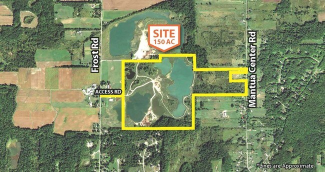
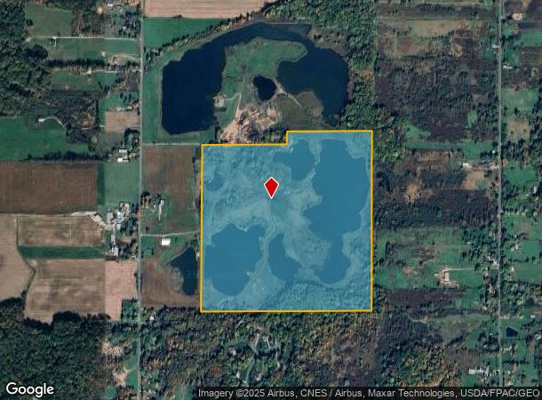
12018 Frost Rd
Akron, OH
Wilson S W
23-015-00-00-005-000
LOT 15 SW MH REG 8829
Agriculturalland
Portage
X
Ohio
39133C0035D
15
2024
118.91 AC
2024
Portage County
600200
Cleveland
3,600 SF
DEMOGRAPHICS near 12018 Frost Rd
1 Mile
3 Mile
5 Mile
2024 Total Population
467
5,730
19,241
2029 Population
474
5,774
19,416
Pop Growth 2024-2029
+ 1.50%
+ 0.77%
+ 0.91%
Average Age
46
44
43
2024 Total Households
189
2,307
7,248
HH Growth 2024-2029
+ 1.06%
+ 0.65%
+ 0.80%
Median Household Inc
$95,312
$85,972
$108,702
Avg Household Size
2.50
2.50
2.60
2024 Avg HH Vehicles
2.00
2.00
2.00
Median Home Value
$230,769
$250,849
$304,227
Median Year Built
1967
1968
1976
Nearby Places
Map Layers
Map Styles
 Street
 Aerial
- Restaurants
- Banks
- Shops
- Fitness
- Groceries
PUBLIC TRANSPORTATION
AIRPORT
Akron-Canton Regional
DRIVE
WALK
Distance
Akron-Canton Regional
62 min
45.3 mi
Freight Ports
Port of Toledo
DRIVE
WALK
Distance
Port of Toledo
168 min
143.1 mi
SALE & LEASE HISTORY
LISTING DATE
SALE/LEASE

Sep 24, 2016
For Sale
Feb 09, 2017
For Sale
Nearby Properties
Address
Land Use
TOTAL SIZE
Lot Size
Zoning
Address
Land Use
TOTAL SIZE
Lot Size
Zoning
129,894 SF
32.27 AC
Address
Land Use
TOTAL SIZE
Lot Size
Zoning
211,593 SF
64.96 AC
Address
Land Use
TOTAL SIZE
Lot Size
Zoning
18,878 SF
209.39 AC
Address
Land Use
TOTAL SIZE
Lot Size
Zoning
152,300 SF
16.72 AC
Address
Land Use
TOTAL SIZE
Lot Size
Zoning
38,460 SF
15 AC
Address
Land Use
TOTAL SIZE
Lot Size
Zoning
18,700 SF
3 AC
Address
Land Use
TOTAL SIZE
Lot Size
Zoning
17,364 SF
10.73 AC
R1
Address
Land Use
TOTAL SIZE
Lot Size
Zoning
202.27 AC
R1
Address
Land Use
TOTAL SIZE
Lot Size
Zoning
3,562 SF
234.66 AC
Address
Land Use
TOTAL SIZE
Lot Size
Zoning
7,163 SF
27.86 AC
Address
Land Use
TOTAL SIZE
Lot Size
Zoning
20,915 SF
2.66 AC
Address
Land Use
TOTAL SIZE
Lot Size
Zoning
3,170 SF
183.40 AC
Address
Land Use
TOTAL SIZE
Lot Size
Zoning
8,555 SF
73.42 AC
Address
Land Use
TOTAL SIZE
Lot Size
Zoning
6,898 SF
134.22 AC
Address
Land Use
TOTAL SIZE
Lot Size
Zoning
34,840 SF
2 AC
Address
Land Use
TOTAL SIZE
Lot Size
Zoning
30,464 SF
4.18 AC
Address
Land Use
TOTAL SIZE
Lot Size
Zoning
2,800 SF
59.38 AC
Address
Land Use
TOTAL SIZE
Lot Size
Zoning
4,315 SF
94.69 AC
Address
Land Use
TOTAL SIZE
Lot Size
Zoning
27,642 SF
24.13 AC
Address
Land Use
TOTAL SIZE
Lot Size
Zoning
7,130 SF
132.78 AC
Address
Land Use
TOTAL SIZE
Lot Size
Zoning
24,225 SF
1 AC
Address
Land Use
TOTAL SIZE
Lot Size
Zoning
8,826 SF
13.30 AC
Address
Land Use
TOTAL SIZE
Lot Size
Zoning
4,208 SF
101.03 AC
Address
Land Use
TOTAL SIZE
Lot Size
Zoning
7,322 SF
27.02 AC
Address
Land Use
TOTAL SIZE
Lot Size
Zoning
57.78 AC
Address
Land Use
TOTAL SIZE
Lot Size
Zoning
11,664 SF
2 AC
Address
Land Use
TOTAL SIZE
Lot Size
Zoning
131.45 AC
R1
Address
Land Use
TOTAL SIZE
Lot Size
Zoning
8,409 SF
112.25 AC
Address
Land Use
TOTAL SIZE
Lot Size
Zoning
5,258 SF
85.20 AC
Address
Land Use
TOTAL SIZE
Lot Size
Zoning
117.80 AC
The World's #1 Commercial Real Estate Marketplace
Connect with us
© 2025 CoStar Group
The information above has been obtained from sources believed reliable. While we do not doubt its accuracy we have not verified it and make no guarantee, warranty or representation about it. It is your responsibility to independently confirm its accuracy and completeness. Any projections, opinions, assumptions, or estimates used are for example only and do not represent the current or future performance of the property. The value of this transaction to you depends on tax and other factors which should be evaluated by your tax, financial, and legal advisors. You and your advisors should conduct a careful, independent investigation of the property to determine to your satisfaction the suitability of the property for your needs.