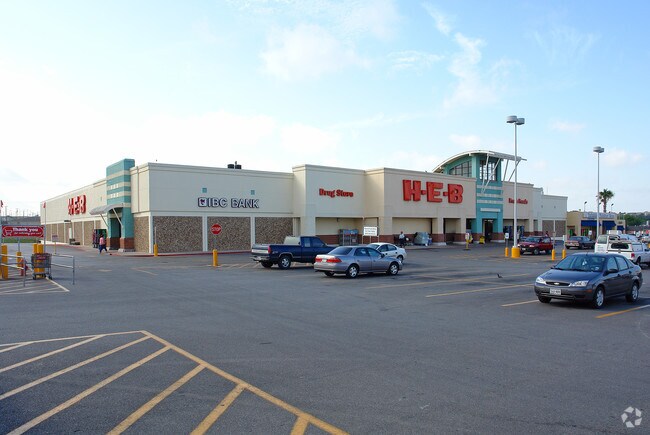
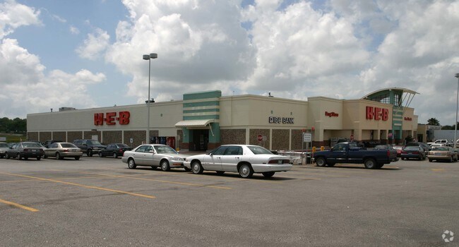
Property Record
12018 Perrin Beitel Rd, San Antonio, TX 78217

NEARBY LISTINGS FOR SALE OR LEASE
Property Detail
12018 Perrin Beitel Rd
San Antonio-New Braunfels, TX
Conv A/S Code
14940-001-0052
NCB 14940 BLK 1 LOT 1, 2 & 5 2021- RMS PER PLAT 20002/27 FILED 10-23-2020. ASGIS01-04-2021.2015 - MERGE ACCTS 564092 & 564097 PER APPRAISER CR #32911
Supermarket
Bexar
X
Texas
48029C0270G
52
2024
3.92 AC
2025
Northeast
121205
San Antonio
54,610 SF
DEMOGRAPHICS near 12018 Perrin Beitel Rd
1 Mile
3 Mile
5 Mile
2024 Total Population
11,260
96,036
266,110
2029 Population
11,874
101,273
282,157
Pop Growth 2024-2029
+ 5.45%
+ 5.45%
+ 6.03%
Average Age
38
39
39
2024 Total Households
4,626
38,825
105,054
HH Growth 2024-2029
+ 5.64%
+ 5.65%
+ 6.20%
Median Household Inc
$52,025
$59,158
$64,053
Avg Household Size
2.40
2.40
2.50
2024 Avg HH Vehicles
2.00
2.00
2.00
Median Home Value
$155,802
$186,110
$212,647
Median Year Built
1977
1981
1983
Nearby Places
Map Layers
Map Styles
 Street
 Aerial
- Restaurants
- Banks
- Shops
- Fitness
- Groceries
PUBLIC TRANSPORTATION
AIRPORT
San Antonio International
DRIVE
WALK
Distance
San Antonio International
11 min
5.6 mi
Freight Ports
Calhoun Port
DRIVE
WALK
Distance
Calhoun Port
184 min
151.7 mi
SALE & LEASE HISTORY
LISTING DATE
SALE/LEASE

Nov 06, 2018
For Lease
Dec 18, 2020
For Lease
Nearby Properties
Address
Land Use
TOTAL SIZE
Lot Size
Zoning
Address
Land Use
TOTAL SIZE
Lot Size
Zoning
359,349 SF
23.59 AC
Address
Land Use
TOTAL SIZE
Lot Size
Zoning
239,264 SF
9.02 AC
Address
Land Use
TOTAL SIZE
Lot Size
Zoning
266,702 SF
13.49 AC
Address
Land Use
TOTAL SIZE
Lot Size
Zoning
288,350 SF
13.01 AC
Address
Land Use
TOTAL SIZE
Lot Size
Zoning
229,077 SF
10.06 AC
Address
Land Use
TOTAL SIZE
Lot Size
Zoning
46,674 SF
53.43 AC
Address
Land Use
TOTAL SIZE
Lot Size
Zoning
180,000 SF
40.73 AC
Address
Land Use
TOTAL SIZE
Lot Size
Zoning
92,859 SF
11.95 AC
Address
Land Use
TOTAL SIZE
Lot Size
Zoning
265,015 SF
12.81 AC
Address
Land Use
TOTAL SIZE
Lot Size
Zoning
205,862 SF
10.79 AC
Address
Land Use
TOTAL SIZE
Lot Size
Zoning
275,327 SF
13.52 AC
Address
Land Use
TOTAL SIZE
Lot Size
Zoning
373,134 SF
16.29 AC
Address
Land Use
TOTAL SIZE
Lot Size
Zoning
263,209 SF
13.67 AC
Address
Land Use
TOTAL SIZE
Lot Size
Zoning
257,263 SF
10.07 AC
Address
Land Use
TOTAL SIZE
Lot Size
Zoning
276,202 SF
17.32 AC
Address
Land Use
TOTAL SIZE
Lot Size
Zoning
257,734 SF
5.57 AC
Address
Land Use
TOTAL SIZE
Lot Size
Zoning
324,905 SF
22.32 AC
Address
Land Use
TOTAL SIZE
Lot Size
Zoning
212,078 SF
9.83 AC
Address
Land Use
TOTAL SIZE
Lot Size
Zoning
213,566 SF
10.17 AC
Address
Land Use
TOTAL SIZE
Lot Size
Zoning
241,922 SF
18.20 AC
Address
Land Use
TOTAL SIZE
Lot Size
Zoning
261,471 SF
11 AC
Address
Land Use
TOTAL SIZE
Lot Size
Zoning
312,516 SF
15.61 AC
Address
Land Use
TOTAL SIZE
Lot Size
Zoning
325,697 SF
18.17 AC
Address
Land Use
TOTAL SIZE
Lot Size
Zoning
228,927 SF
16.25 AC
Address
Land Use
TOTAL SIZE
Lot Size
Zoning
191,072 SF
9.78 AC
Address
Land Use
TOTAL SIZE
Lot Size
Zoning
190,357 SF
18.08 AC
Address
Land Use
TOTAL SIZE
Lot Size
Zoning
231,706 SF
10.47 AC
Address
Land Use
TOTAL SIZE
Lot Size
Zoning
187,743 SF
10.41 AC
Address
Land Use
TOTAL SIZE
Lot Size
Zoning
94,659 SF
13.16 AC
Address
Land Use
TOTAL SIZE
Lot Size
Zoning
166,324 SF
11.72 AC
The World's #1 Commercial Real Estate Marketplace
Connect with us
© 2025 CoStar Group
The information above has been obtained from sources believed reliable. While we do not doubt its accuracy we have not verified it and make no guarantee, warranty or representation about it. It is your responsibility to independently confirm its accuracy and completeness. Any projections, opinions, assumptions, or estimates used are for example only and do not represent the current or future performance of the property. The value of this transaction to you depends on tax and other factors which should be evaluated by your tax, financial, and legal advisors. You and your advisors should conduct a careful, independent investigation of the property to determine to your satisfaction the suitability of the property for your needs.