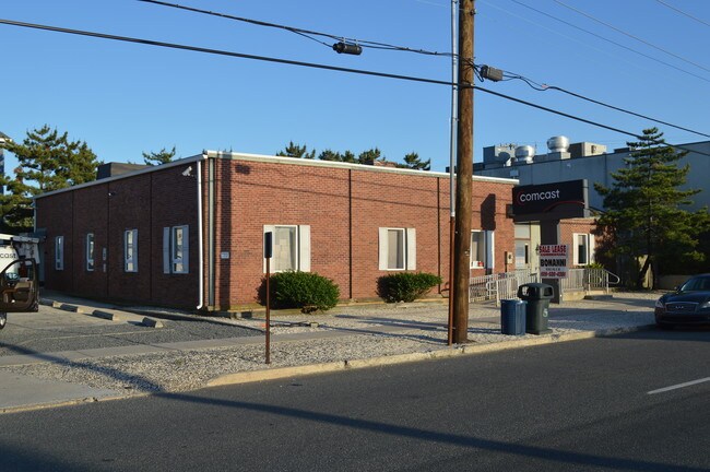
Property Record
1202 Boulevard Blvd, Ship Bottom, NJ 08008
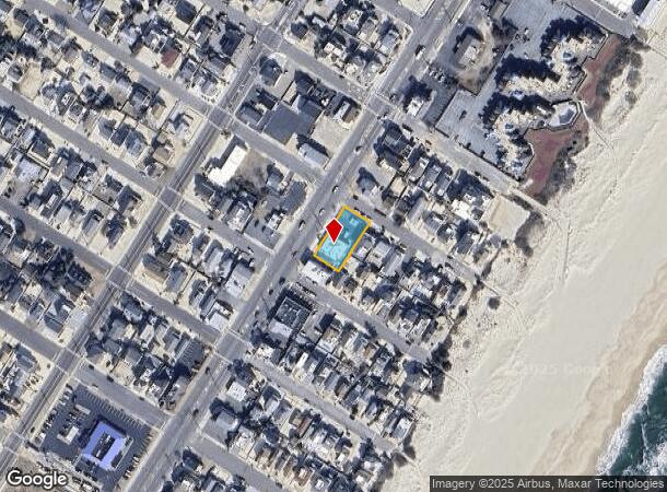
NEARBY LISTINGS FOR SALE OR LEASE
Property Detail
1202 Boulevard Blvd
29-00086-0000-00009
160X80 10,11
Commercialnec
Ocean
AE
New Jersey
34029C0518G
9
2024
0.29 AC
2025
Ocean County
738001
Northern New Jersey
4,485 SF
New York-Jersey City-White Plains, NY-NJ
DEMOGRAPHICS near 1202 Boulevard Blvd
1 Mile
3 Mile
5 Mile
2024 Total Population
5,359
15,767
27,862
2029 Population
6,335
18,688
32,869
Pop Growth 2024-2029
+ 18.21%
+ 18.53%
+ 17.97%
Average Age
52
53
52
2024 Total Households
2,569
7,328
12,974
HH Growth 2024-2029
+ 17.94%
+ 18.34%
+ 17.86%
Median Household Inc
$95,284
$108,468
$102,723
Avg Household Size
2.00
2.00
2.10
2024 Avg HH Vehicles
2.00
2.00
2.00
Median Home Value
$771,517
$724,524
$697,095
Median Year Built
1973
1980
1981
Nearby Places
Map Layers
Map Styles
 Street
 Aerial
- Restaurants
- Banks
- Shops
- Fitness
- Groceries
PUBLIC TRANSPORTATION
AIRPORT
Atlantic City International
DRIVE
WALK
Distance
Atlantic City International
68 min
37.2 mi
Freight Ports
Port of Philadelphia
DRIVE
WALK
Distance
Port of Philadelphia
82 min
60.3 mi
SALE & LEASE HISTORY
LISTING DATE
SALE/LEASE

Jun 21, 2018
For Lease
Jun 21, 2018
For Sale
Nearby Properties
Address
Land Use
TOTAL SIZE
Lot Size
Zoning
Address
Land Use
TOTAL SIZE
Lot Size
Zoning
18,880 SF
1.93 AC
GC
Address
Land Use
TOTAL SIZE
Lot Size
Zoning
5.62 AC
R50
Address
Land Use
TOTAL SIZE
Lot Size
Zoning
10,292 SF
1.28 AC
P
Address
Land Use
TOTAL SIZE
Lot Size
Zoning
17,884 SF
0.48 AC
P
Address
Land Use
TOTAL SIZE
Lot Size
Zoning
34,500 SF
2.53 AC
RA
Address
Land Use
TOTAL SIZE
Lot Size
Zoning
6,776 SF
3.96 AC
P
Address
Land Use
TOTAL SIZE
Lot Size
Zoning
27,365 SF
2.25 AC
R50
Address
Land Use
TOTAL SIZE
Lot Size
Zoning
14,440 SF
0.83 AC
MFR
Address
Land Use
TOTAL SIZE
Lot Size
Zoning
0.94 AC
R50
Address
Land Use
TOTAL SIZE
Lot Size
Zoning
2,892 SF
1.85 AC
RA
Address
Land Use
TOTAL SIZE
Lot Size
Zoning
5,904 SF
1.29 AC
B
Address
Land Use
TOTAL SIZE
Lot Size
Zoning
6,101 SF
0.92 AC
RA
Address
Land Use
TOTAL SIZE
Lot Size
Zoning
1.13 AC
R10E
Address
Land Use
TOTAL SIZE
Lot Size
Zoning
3,444 SF
0.86 AC
R50
Address
Land Use
TOTAL SIZE
Lot Size
Zoning
Address
Land Use
TOTAL SIZE
Lot Size
Zoning
1.93 AC
RA
Address
Land Use
TOTAL SIZE
Lot Size
Zoning
14,906 SF
1.26 AC
MC
Address
Land Use
TOTAL SIZE
Lot Size
Zoning
20,543 SF
5.56 AC
MC
Address
Land Use
TOTAL SIZE
Lot Size
Zoning
0.49 AC
RA
Address
Land Use
TOTAL SIZE
Lot Size
Zoning
2,990 SF
13.20 AC
MC
Address
Land Use
TOTAL SIZE
Lot Size
Zoning
9,094 SF
0.83 AC
B
Address
Land Use
TOTAL SIZE
Lot Size
Zoning
392 SF
0.31 AC
RA
Address
Land Use
TOTAL SIZE
Lot Size
Zoning
1,824 SF
0.39 AC
RA
Address
Land Use
TOTAL SIZE
Lot Size
Zoning
21,873 SF
0.41 AC
B
Address
Land Use
TOTAL SIZE
Lot Size
Zoning
2,406 SF
0.92 AC
GCEC
Address
Land Use
TOTAL SIZE
Lot Size
Zoning
0.51 AC
GC
Address
Land Use
TOTAL SIZE
Lot Size
Zoning
9,929 SF
1.93 AC
GC
Address
Land Use
TOTAL SIZE
Lot Size
Zoning
7,646 SF
0.46 AC
RA
Address
Land Use
TOTAL SIZE
Lot Size
Zoning
1.03 AC
R10
Address
Land Use
TOTAL SIZE
Lot Size
Zoning
7,760 SF
0.83 AC
B
The World's #1 Commercial Real Estate Marketplace
Connect with us
© 2025 CoStar Group
The information above has been obtained from sources believed reliable. While we do not doubt its accuracy we have not verified it and make no guarantee, warranty or representation about it. It is your responsibility to independently confirm its accuracy and completeness. Any projections, opinions, assumptions, or estimates used are for example only and do not represent the current or future performance of the property. The value of this transaction to you depends on tax and other factors which should be evaluated by your tax, financial, and legal advisors. You and your advisors should conduct a careful, independent investigation of the property to determine to your satisfaction the suitability of the property for your needs.