Property Record
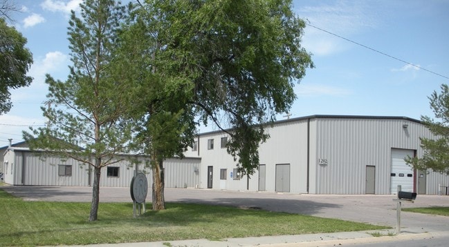
1202 E Saint Francis St, Rapid City, SD 57701

Property Detail
1202 E Saint Francis St
Rapid City, SD
NICHOLLS SUBD, W150' OF LOT 2
0054073
Pennington
Publicstorage
South Dakota
C and X Area of minimal flood hazard, usually depicted on FIRMs as above the 500-year flood level.
2
0
0.48 AC
2025
Rapid City
010600
Other Market Areas
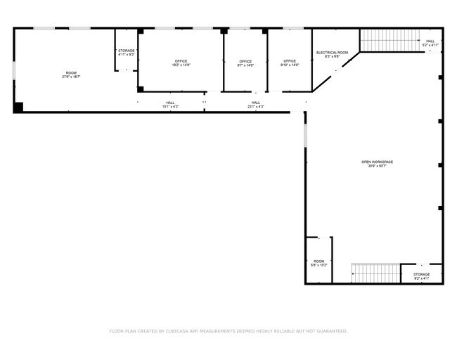
8,400 SF
NEARBY LISTINGS FOR SALE OR LEASE
DEMOGRAPHICS near 1202 E Saint Francis St
1 mile
3 mile
5 mile
2024 Total Population
6,126
51,807
83,257
2029 Population
6,339
54,221
86,892
Pop Growth 2024-2029
+ 3.48%
+ 4.66%
+ 4.37%
Average Age
38
40
40
2024 Total Households
2,589
21,409
34,802
HH Growth 2024-2029
+ 3.86%
+ 4.94%
+ 4.61%
Median Household Inc
$50,590
$66,250
$70,563
Avg Household Size
2.10
2.20
2.20
2024 Avg HH Vehicles
2.00
2.00
2.00
Median Home Value
$256,301
$273,555
$292,271
Median Year Built
1973
1980
1984
Nearby Places
Map Layers
Map Styles
 Street
 Aerial
Transit
 Traffic
 Biking
Places
Listings with unknown addresses are not visible on the map
- Restaurants
- Banks
- Shops
- Fitness
- Groceries
PUBLIC TRANSPORTATION
AIRPORT
Rapid City Regional
Drive
Walk
Distance
Rapid City Regional
15 min
8.7 mi
Nearby Properties
Address
Land Use
TOTAL SIZE
Lot Size
Zoning
Address
Land Use
TOTAL SIZE
Lot Size
Zoning
4,748 SF
9.94 AC
Address
Land Use
TOTAL SIZE
Lot Size
Zoning
19,728 SF
7.67 AC
Address
Land Use
TOTAL SIZE
Lot Size
Zoning
6,480 SF
11.58 AC
Address
Land Use
TOTAL SIZE
Lot Size
Zoning
5,448 SF
8 AC
Address
Land Use
TOTAL SIZE
Lot Size
Zoning
14,484 SF
5.20 AC
Address
Land Use
TOTAL SIZE
Lot Size
Zoning
12,258 SF
7.62 AC
Address
Land Use
TOTAL SIZE
Lot Size
Zoning
55,442 SF
23.96 AC
Address
Land Use
TOTAL SIZE
Lot Size
Zoning
4,005 SF
12.09 AC
Address
Land Use
TOTAL SIZE
Lot Size
Zoning
6,820 SF
10.60 AC
Address
Land Use
TOTAL SIZE
Lot Size
Zoning
38,030 SF
13.47 AC
Address
Land Use
TOTAL SIZE
Lot Size
Zoning
188,360 SF
37.53 AC
Address
Land Use
TOTAL SIZE
Lot Size
Zoning
8,764 SF
6 AC
Address
Land Use
TOTAL SIZE
Lot Size
Zoning
2,058 SF
6.70 AC
Address
Land Use
TOTAL SIZE
Lot Size
Zoning
2,018 SF
5.66 AC
Address
Land Use
TOTAL SIZE
Lot Size
Zoning
48,108 SF
38.14 AC
Address
Land Use
TOTAL SIZE
Lot Size
Zoning
26,807 SF
0.58 AC
Address
Land Use
TOTAL SIZE
Lot Size
Zoning
46,644 SF
11.89 AC
Address
Land Use
TOTAL SIZE
Lot Size
Zoning
24,360 SF
4.24 AC
Address
Land Use
TOTAL SIZE
Lot Size
Zoning
2,865 SF
7.08 AC
Address
Land Use
TOTAL SIZE
Lot Size
Zoning
29,226 SF
1.38 AC
Address
Land Use
TOTAL SIZE
Lot Size
Zoning
14,360 SF
2.07 AC
Address
Land Use
TOTAL SIZE
Lot Size
Zoning
28,584 SF
5.62 AC
Address
Land Use
TOTAL SIZE
Lot Size
Zoning
25,762 SF
5.74 AC
Address
Land Use
TOTAL SIZE
Lot Size
Zoning
62,209 SF
14.15 AC
Address
Land Use
TOTAL SIZE
Lot Size
Zoning
10,608 SF
10.90 AC
Address
Land Use
TOTAL SIZE
Lot Size
Zoning
714 SF
11.14 AC
Address
Land Use
TOTAL SIZE
Lot Size
Zoning
147,325 SF
11.93 AC
Address
Land Use
TOTAL SIZE
Lot Size
Zoning
162,960 SF
22.56 AC
Address
Land Use
TOTAL SIZE
Lot Size
Zoning
26,845 SF
3.49 AC
The World's #1 Commercial Real Estate Marketplace
Connect with us
© 2026 CoStar Group
The information above has been obtained from sources believed reliable. While we do not doubt its accuracy we have not verified it and make no guarantee, warranty or representation about it. It is your responsibility to independently confirm its accuracy and completeness. Any projections, opinions, assumptions, or estimates used are for example only and do not represent the current or future performance of the property. The value of this transaction to you depends on tax and other factors which should be evaluated by your tax, financial, and legal advisors. You and your advisors should conduct a careful, independent investigation of the property to determine to your satisfaction the suitability of the property for your needs.