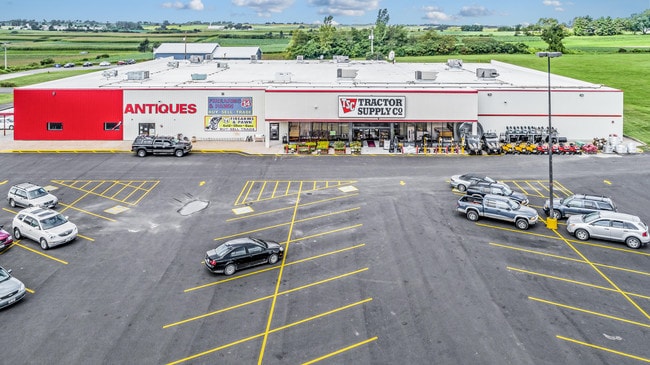
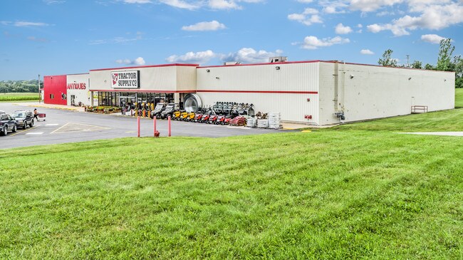
Property Record
1202 N Main St, Viroqua, WI 54665


Save to a Folder
{{folder.Name}}
{{folder.ListingIds.length}} Properties
{{folder.ListingIds.length}} Property
Create a New Folder
Property Detail
1202 N Main St
La Crosse-Onalaska, WI-MN
PART OF THE NE SE A PARCEL BEING 690 X 411.91 - EXC .01 ACRES TO STATE OF WI DOT FOR ROW SEE PRCL #1363.0001
286-01375-0000
Vernon
Commercialnec
Wisconsin
B and X Area of moderate flood hazard, usually the area between the limits of the 100-year and 500-year floods.
6.51 AC
2025
Wisconsin South Area
2025
Other Market Areas
960400
NEARBY LISTINGS FOR SALE OR LEASE
DEMOGRAPHICS near 1202 N Main St
1 mile
3 mile
5 mile
2025 Total Population
2,019
6,318
7,451
2030 Population
2,068
6,500
7,614
Pop Growth 2025-2030
+ 2.43%
+ 2.88%
+ 2.19%
Average Age
45
44
44
2025 Total Households
909
2,775
3,193
HH Growth 2025-2030
+ 2.64%
+ 2.92%
+ 2.25%
Median Household Inc
$60,196
$69,313
$70,609
Avg Household Size
2.10
2.20
2.20
2025 Avg HH Vehicles
1.00
2.00
2.00
Median Home Value
$230,994
$247,664
$251,745
Median Year Built
1973
1973
1973
Nearby Places
Map Layers
Map Styles
 Street
 Aerial
Layers
 Traffic
 Biking
Places
Listings with unknown addresses are not visible on the map
- Restaurants
- Banks
- Shops
- Fitness
- Groceries
PUBLIC TRANSPORTATION
AIRPORT
La Crosse Regional
Drive
Walk
Distance
La Crosse Regional
65 min
41.5 mi
Freight Ports
Port Milwaukee
Drive
Walk
Distance
Port Milwaukee
236 min
177.6 mi
SALE & LEASE HISTORY
LISTING DATE
SALE/LEASE

Oct 01, 2018
For Sale
Nearby Properties
Address
Land Use
TOTAL SIZE
Lot Size
Zoning
Address
Land Use
TOTAL SIZE
Lot Size
Zoning
Address
Land Use
TOTAL SIZE
Lot Size
Zoning
18.73 AC
Address
Land Use
TOTAL SIZE
Lot Size
Zoning
0.40 AC
Address
Land Use
TOTAL SIZE
Lot Size
Zoning
7.55 AC
Address
Land Use
TOTAL SIZE
Lot Size
Zoning
3.97 AC
Address
Land Use
TOTAL SIZE
Lot Size
Zoning
0.93 AC
Address
Land Use
TOTAL SIZE
Lot Size
Zoning
10.50 AC
Address
Land Use
TOTAL SIZE
Lot Size
Zoning
2.03 AC
Address
Land Use
TOTAL SIZE
Lot Size
Zoning
1.47 AC
Address
Land Use
TOTAL SIZE
Lot Size
Zoning
8.50 AC
Address
Land Use
TOTAL SIZE
Lot Size
Zoning
3.42 AC
Address
Land Use
TOTAL SIZE
Lot Size
Zoning
9.71 AC
Address
Land Use
TOTAL SIZE
Lot Size
Zoning
0.27 AC
Address
Land Use
TOTAL SIZE
Lot Size
Zoning
5.40 AC
Address
Land Use
TOTAL SIZE
Lot Size
Zoning
7.64 AC
Address
Land Use
TOTAL SIZE
Lot Size
Zoning
2.31 AC
Address
Land Use
TOTAL SIZE
Lot Size
Zoning
0.12 AC
Address
Land Use
TOTAL SIZE
Lot Size
Zoning
0.34 AC
Address
Land Use
TOTAL SIZE
Lot Size
Zoning
1.30 AC
Address
Land Use
TOTAL SIZE
Lot Size
Zoning
Address
Land Use
TOTAL SIZE
Lot Size
Zoning
3.41 AC
Address
Land Use
TOTAL SIZE
Lot Size
Zoning
6.36 AC
Address
Land Use
TOTAL SIZE
Lot Size
Zoning
1.40 AC
Address
Land Use
TOTAL SIZE
Lot Size
Zoning
3.36 AC
Address
Land Use
TOTAL SIZE
Lot Size
Zoning
3.17 AC
Address
Land Use
TOTAL SIZE
Lot Size
Zoning
4.76 AC
Address
Land Use
TOTAL SIZE
Lot Size
Zoning
0.82 AC
Address
Land Use
TOTAL SIZE
Lot Size
Zoning
0.91 AC
The World's #1 Commercial Real Estate Marketplace
Connect with us
© 2026 CoStar Group
The information above has been obtained from sources believed reliable. While we do not doubt its accuracy we have not verified it and make no guarantee, warranty or representation about it. It is your responsibility to independently confirm its accuracy and completeness. Any projections, opinions, assumptions, or estimates used are for example only and do not represent the current or future performance of the property. The value of this transaction to you depends on tax and other factors which should be evaluated by your tax, financial, and legal advisors. You and your advisors should conduct a careful, independent investigation of the property to determine to your satisfaction the suitability of the property for your needs.