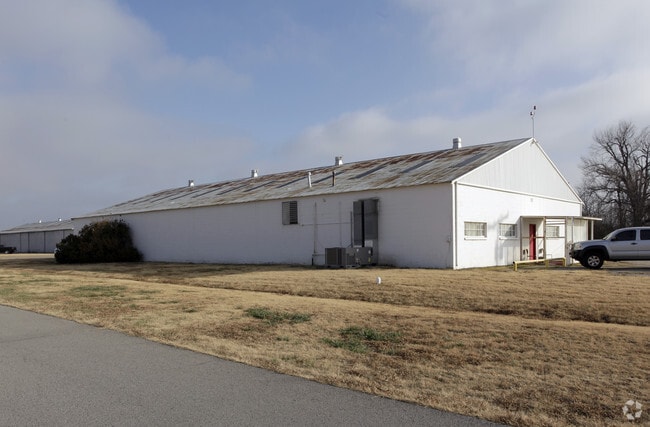
Property Record
1202 W 36Th St N, Tulsa, OK 74127


NEARBY LISTINGS FOR SALE OR LEASE
-
-
View all Tulsa listings for lease on LoopNet.com
Property Detail
1202 W 36Th St N
570066309
Non-Subdivision
Officebuilding
15-20-12 COMM AT SE/C-W 1411.75'-N 34 27 30 W 1615.07'-E 1376' TO POB-S 726'-W 300'-N 726'-E 300' TO POB, LESS .07AC CO RD
X
Osage
40143C0210L
Oklahoma
2024
4.93 AC
2025
Osage County
940005
Tulsa
3,000 SF
Tulsa, OK
DEMOGRAPHICS near 1202 W 36Th St N
1 Mile
3 Mile
5 Mile
2024 Total Population
942
35,011
94,043
2029 Population
961
36,640
98,995
Pop Growth 2024-2029
+ 2.02%
+ 4.65%
+ 5.27%
Average Age
40
38
37
2024 Total Households
389
13,802
37,873
HH Growth 2024-2029
+ 1.80%
+ 4.62%
+ 5.53%
Median Household Inc
$22,413
$32,689
$37,393
Avg Household Size
2.30
2.40
2.30
2024 Avg HH Vehicles
1.00
2.00
2.00
Median Home Value
$78,260
$91,910
$86,307
Median Year Built
1964
1962
1959
Nearby Places
Map Layers
Map Styles
 Street
 Aerial
- Restaurants
- Banks
- Shops
- Fitness
- Groceries
PUBLIC TRANSPORTATION
AIRPORT
Tulsa International
DRIVE
WALK
Distance
Tulsa International
14 min
7.3 mi
Freight Ports
Tulsa Port Of Catoosa
DRIVE
WALK
Distance
Tulsa Port Of Catoosa
24 min
15.4 mi
SALE & LEASE HISTORY
LISTING DATE
SALE/LEASE

Sep 25, 2016
For Lease
Nearby Properties
Address
Land Use
TOTAL SIZE
Lot Size
Zoning
Address
Land Use
TOTAL SIZE
Lot Size
Zoning
10,736 SF
101.62 AC
Address
Land Use
TOTAL SIZE
Lot Size
Zoning
92,407 SF
6.02 AC
CS
Address
Land Use
TOTAL SIZE
Lot Size
Zoning
144,570 SF
44.59 AC
RM2
Address
Land Use
TOTAL SIZE
Lot Size
Zoning
161,670 SF
8.57 AC
IL
Address
Land Use
TOTAL SIZE
Lot Size
Zoning
106,579 SF
6.76 AC
RM1
Address
Land Use
TOTAL SIZE
Lot Size
Zoning
56,476 SF
2.89 AC
RM2
Address
Land Use
TOTAL SIZE
Lot Size
Zoning
67,334 SF
0.84 AC
IL
Address
Land Use
TOTAL SIZE
Lot Size
Zoning
40,433 SF
2.92 AC
IL
Address
Land Use
TOTAL SIZE
Lot Size
Zoning
29,589 SF
12.37 AC
AG
Address
Land Use
TOTAL SIZE
Lot Size
Zoning
29,110 SF
3.96 AC
IL
Address
Land Use
TOTAL SIZE
Lot Size
Zoning
92,364 SF
8.58 AC
RM1
Address
Land Use
TOTAL SIZE
Lot Size
Zoning
149,204 SF
3.48 AC
CH
Address
Land Use
TOTAL SIZE
Lot Size
Zoning
84,400 SF
2.79 AC
CH
Address
Land Use
TOTAL SIZE
Lot Size
Zoning
33,340 SF
10.08 AC
AG
Address
Land Use
TOTAL SIZE
Lot Size
Zoning
37,400 SF
2.13 AC
CS
Address
Land Use
TOTAL SIZE
Lot Size
Zoning
33,750 SF
5.07 AC
RM1
Address
Land Use
TOTAL SIZE
Lot Size
Zoning
39,889 SF
3.62 AC
IL
Address
Land Use
TOTAL SIZE
Lot Size
Zoning
20,818 SF
2.09 AC
RS4
Address
Land Use
TOTAL SIZE
Lot Size
Zoning
16,164 SF
1.23 AC
CN
Address
Land Use
TOTAL SIZE
Lot Size
Zoning
45,883 SF
10.29 AC
RS3
Address
Land Use
TOTAL SIZE
Lot Size
Zoning
51,810 SF
7.61 AC
CS
Address
Land Use
TOTAL SIZE
Lot Size
Zoning
27,403 SF
70.91 AC
AG
Address
Land Use
TOTAL SIZE
Lot Size
Zoning
35,336 SF
1.68 AC
RS3
Address
Land Use
TOTAL SIZE
Lot Size
Zoning
24,812 SF
1.13 AC
CH
Address
Land Use
TOTAL SIZE
Lot Size
Zoning
31,154 SF
9.74 AC
RS3
Address
Land Use
TOTAL SIZE
Lot Size
Zoning
20,750 SF
1.10 AC
NCU
Address
Land Use
TOTAL SIZE
Lot Size
Zoning
12,421 SF
1.26 AC
IL
Address
Land Use
TOTAL SIZE
Lot Size
Zoning
34,580 SF
15 AC
RS3
Address
Land Use
TOTAL SIZE
Lot Size
Zoning
38,796 SF
4.44 AC
RM1
The World's #1 Commercial Real Estate Marketplace
Connect with us
© 2025 CoStar Group
The information above has been obtained from sources believed reliable. While we do not doubt its accuracy we have not verified it and make no guarantee, warranty or representation about it. It is your responsibility to independently confirm its accuracy and completeness. Any projections, opinions, assumptions, or estimates used are for example only and do not represent the current or future performance of the property. The value of this transaction to you depends on tax and other factors which should be evaluated by your tax, financial, and legal advisors. You and your advisors should conduct a careful, independent investigation of the property to determine to your satisfaction the suitability of the property for your needs.