Property Record
1202 W Betteravia Rd, Santa Maria, CA 93455
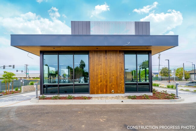

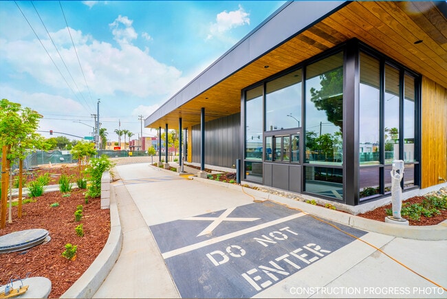

This Property Is For Sale
NEARBY LISTINGS FOR SALE OR LEASE
Property Detail
1202 W Betteravia Rd
Santa Maria-Santa Barbara, CA
POR SE1/4 NE 1/4 SEC 28 T.10N., R.34W.
111-400-032
Santa Barbara
Commercialnec
California
X
2
06083C0187F
0.50 AC
2024
North SB County
2025
Santa Barbara/Sta Maria/Goleta
002011
DEMOGRAPHICS near 1202 W Betteravia Rd
1 Mile
3 Mile
5 Mile
2024 Total Population
14,656
79,204
141,887
2029 Population
14,872
79,535
141,459
Pop Growth 2024-2029
+ 1.47%
+ 0.42%
(0.30%)
Average Age
34
34
35
2024 Total Households
4,202
22,008
40,248
HH Growth 2024-2029
+ 1.33%
+ 0.45%
(0.31%)
Median Household Inc
$95,283
$79,677
$86,545
Avg Household Size
3.40
3.50
3.40
2024 Avg HH Vehicles
2.00
2.00
2.00
Median Home Value
$596,927
$576,940
$599,212
Median Year Built
2005
1981
1980
Nearby Places
Map Layers
Map Styles
 Street
 Aerial
- Restaurants
- Banks
- Shops
- Fitness
- Groceries
PUBLIC TRANSPORTATION
COMMUTER RAIL
DRIVE
WALK
Distance
16 min
9.7 mi
AIRPORT
San Luis County Regional
DRIVE
WALK
Distance
San Luis County Regional
42 min
31.4 mi
Nearby Properties
Address
Land Use
TOTAL SIZE
Lot Size
Zoning
Address
Land Use
TOTAL SIZE
Lot Size
Zoning
211.15 AC
Address
Land Use
TOTAL SIZE
Lot Size
Zoning
49.99 AC
Address
Land Use
TOTAL SIZE
Lot Size
Zoning
14.45 AC
Address
Land Use
TOTAL SIZE
Lot Size
Zoning
146.75 AC
Address
Land Use
TOTAL SIZE
Lot Size
Zoning
6.35 AC
Address
Land Use
TOTAL SIZE
Lot Size
Zoning
9.46 AC
Address
Land Use
TOTAL SIZE
Lot Size
Zoning
18.19 AC
Address
Land Use
TOTAL SIZE
Lot Size
Zoning
Address
Land Use
TOTAL SIZE
Lot Size
Zoning
9.50 AC
Address
Land Use
TOTAL SIZE
Lot Size
Zoning
17.71 AC
Address
Land Use
TOTAL SIZE
Lot Size
Zoning
4.05 AC
Address
Land Use
TOTAL SIZE
Lot Size
Zoning
Address
Land Use
TOTAL SIZE
Lot Size
Zoning
Address
Land Use
TOTAL SIZE
Lot Size
Zoning
21.09 AC
Address
Land Use
TOTAL SIZE
Lot Size
Zoning
10.75 AC
Address
Land Use
TOTAL SIZE
Lot Size
Zoning
6.36 AC
Address
Land Use
TOTAL SIZE
Lot Size
Zoning
10.81 AC
Address
Land Use
TOTAL SIZE
Lot Size
Zoning
6.17 AC
Address
Land Use
TOTAL SIZE
Lot Size
Zoning
5.80 AC
DR20
Address
Land Use
TOTAL SIZE
Lot Size
Zoning
45.32 AC
Address
Land Use
TOTAL SIZE
Lot Size
Zoning
13.76 AC
Address
Land Use
TOTAL SIZE
Lot Size
Zoning
Address
Land Use
TOTAL SIZE
Lot Size
Zoning
Address
Land Use
TOTAL SIZE
Lot Size
Zoning
Address
Land Use
TOTAL SIZE
Lot Size
Zoning
27.05 AC
Address
Land Use
TOTAL SIZE
Lot Size
Zoning
Address
Land Use
TOTAL SIZE
Lot Size
Zoning
6.11 AC
Address
Land Use
TOTAL SIZE
Lot Size
Zoning
2.81 AC
Address
Land Use
TOTAL SIZE
Lot Size
Zoning
The World's #1 Commercial Real Estate Marketplace
Connect with us
© 2025 CoStar Group
The information above has been obtained from sources believed reliable. While we do not doubt its accuracy we have not verified it and make no guarantee, warranty or representation about it. It is your responsibility to independently confirm its accuracy and completeness. Any projections, opinions, assumptions, or estimates used are for example only and do not represent the current or future performance of the property. The value of this transaction to you depends on tax and other factors which should be evaluated by your tax, financial, and legal advisors. You and your advisors should conduct a careful, independent investigation of the property to determine to your satisfaction the suitability of the property for your needs.