Property Record
12021 Mt Holly-Huntersville Rd, Huntersville, NC 28078
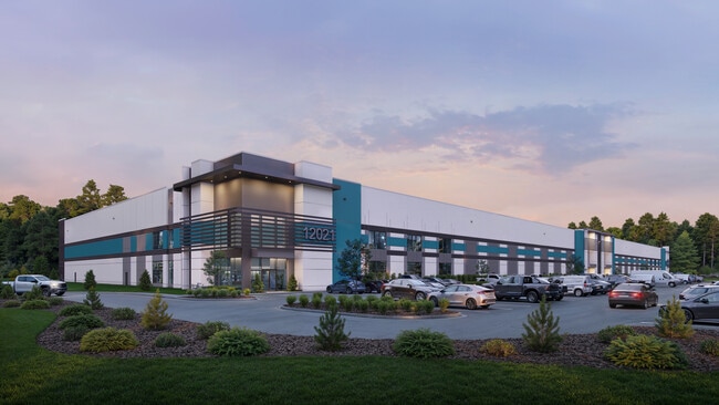
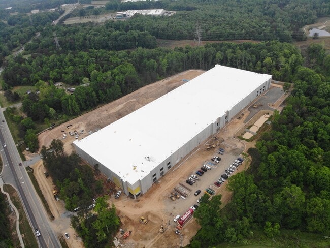
This Property Is For Sale
Current Lease Availabilities
Industrial LEASE
Negotiable
50,000 - 197,206 SF
NEARBY LISTINGS FOR SALE OR LEASE
Property Detail
12021 Mt Holly-Huntersville Rd
Charlotte-Concord-Gastonia, NC-SC
Conveyed To Grantor
017-203-07
SEE 1720306
Industrialgeneral
Mecklenburg
X
North Carolina
3710464000K
6
2024
7.43 AC
2025
North
006212
Charlotte
196,268 SF
DEMOGRAPHICS near 12021 Mt Holly-Huntersville Rd
1 Mile
3 Mile
5 Mile
2024 Total Population
1,707
39,749
126,232
2029 Population
1,855
42,416
133,743
Pop Growth 2024-2029
+ 8.67%
+ 6.71%
+ 5.95%
Average Age
39
37
37
2024 Total Households
667
15,812
48,518
HH Growth 2024-2029
+ 8.70%
+ 6.77%
+ 6.00%
Median Household Inc
$92,555
$94,554
$90,076
Avg Household Size
2.50
2.50
2.50
2024 Avg HH Vehicles
2.00
2.00
2.00
Median Home Value
$330,374
$347,154
$325,342
Median Year Built
2010
2005
2002
Nearby Places
Map Layers
Map Styles
 Street
 Aerial
- Restaurants
- Banks
- Shops
- Fitness
- Groceries
PUBLIC TRANSPORTATION
AIRPORT
Concord-Padgett Regional
DRIVE
WALK
Distance
Concord-Padgett Regional
18 min
10.6 mi
Charlotte/Douglas International
DRIVE
WALK
Distance
Charlotte/Douglas International
28 min
18.6 mi
Freight Ports
North Charleston Terminal
DRIVE
WALK
Distance
North Charleston Terminal
240 min
210.8 mi
Nearby Properties
Address
Land Use
TOTAL SIZE
Lot Size
Zoning
Address
Land Use
TOTAL SIZE
Lot Size
Zoning
417,671 SF
30.58 AC
CICD
Address
Land Use
TOTAL SIZE
Lot Size
Zoning
719,240 SF
55.73 AC
CC
Address
Land Use
TOTAL SIZE
Lot Size
Zoning
338,136 SF
15.13 AC
Address
Land Use
TOTAL SIZE
Lot Size
Zoning
263,035 SF
10.42 AC
CC
Address
Land Use
TOTAL SIZE
Lot Size
Zoning
334,333 SF
19.33 AC
BP
Address
Land Use
TOTAL SIZE
Lot Size
Zoning
246,846 SF
13.56 AC
R3
Address
Land Use
TOTAL SIZE
Lot Size
Zoning
417,771 SF
14.55 AC
BP
Address
Land Use
TOTAL SIZE
Lot Size
Zoning
505,355 SF
37.59 AC
Address
Land Use
TOTAL SIZE
Lot Size
Zoning
223,714 SF
16.93 AC
CB
Address
Land Use
TOTAL SIZE
Lot Size
Zoning
211,601 SF
20.80 AC
Address
Land Use
TOTAL SIZE
Lot Size
Zoning
220,336 SF
11.52 AC
Address
Land Use
TOTAL SIZE
Lot Size
Zoning
129,017 SF
7.27 AC
CC
Address
Land Use
TOTAL SIZE
Lot Size
Zoning
249,694 SF
41.60 AC
NR
Address
Land Use
TOTAL SIZE
Lot Size
Zoning
172,200 SF
8.07 AC
Address
Land Use
TOTAL SIZE
Lot Size
Zoning
165,567 SF
22.80 AC
NR
Address
Land Use
TOTAL SIZE
Lot Size
Zoning
255,119 SF
20.39 AC
R12MFCD
Address
Land Use
TOTAL SIZE
Lot Size
Zoning
134,925 SF
13.68 AC
CC
Address
Land Use
TOTAL SIZE
Lot Size
Zoning
217,845 SF
9.58 AC
CB
Address
Land Use
TOTAL SIZE
Lot Size
Zoning
127,866 SF
3.72 AC
Address
Land Use
TOTAL SIZE
Lot Size
Zoning
211,235 SF
49.22 AC
CI
Address
Land Use
TOTAL SIZE
Lot Size
Zoning
315,420 SF
21.83 AC
Address
Land Use
TOTAL SIZE
Lot Size
Zoning
177,149 SF
15.21 AC
CB
Address
Land Use
TOTAL SIZE
Lot Size
Zoning
588,388 SF
38.51 AC
CB
Address
Land Use
TOTAL SIZE
Lot Size
Zoning
155,951 SF
8.20 AC
Address
Land Use
TOTAL SIZE
Lot Size
Zoning
196,022 SF
9.04 AC
Address
Land Use
TOTAL SIZE
Lot Size
Zoning
150,358 SF
6.01 AC
HC(CD)
Address
Land Use
TOTAL SIZE
Lot Size
Zoning
174,118 SF
10.92 AC
R17MFCD
Address
Land Use
TOTAL SIZE
Lot Size
Zoning
306,007 SF
22.40 AC
Address
Land Use
TOTAL SIZE
Lot Size
Zoning
156,092 SF
17.20 AC
NRCD
Address
Land Use
TOTAL SIZE
Lot Size
Zoning
244,960 SF
14.21 AC
The World's #1 Commercial Real Estate Marketplace
Connect with us
© 2025 CoStar Group
The information above has been obtained from sources believed reliable. While we do not doubt its accuracy we have not verified it and make no guarantee, warranty or representation about it. It is your responsibility to independently confirm its accuracy and completeness. Any projections, opinions, assumptions, or estimates used are for example only and do not represent the current or future performance of the property. The value of this transaction to you depends on tax and other factors which should be evaluated by your tax, financial, and legal advisors. You and your advisors should conduct a careful, independent investigation of the property to determine to your satisfaction the suitability of the property for your needs.