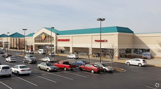
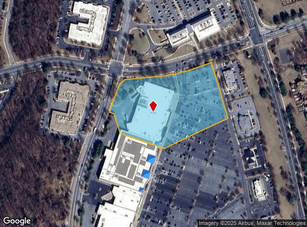
Property Record
12028 Cherry Hill Rd, Silver Spring, MD 20904
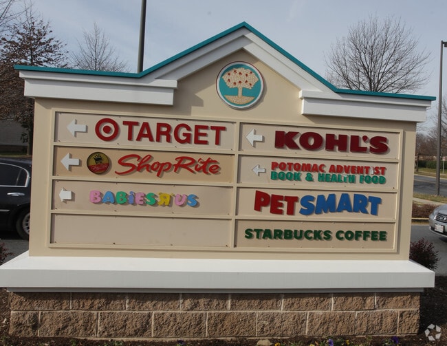

NEARBY LISTINGS FOR SALE OR LEASE
Property Detail
12028 Cherry Hill Rd
Washington-Arlington-Alexandria, DC-VA-MD-WV
Bealls Manor
05-03206167
PAR VVV WESTFARM TECHNOLOGY PARK
Supermarket
Montgomery
X
Maryland
24033C0037E
vvv
2024
5.52 AC
2025
North Silver Spring/Rt 29
701425
Washington, DC
65,750 SF
DEMOGRAPHICS near 12028 Cherry Hill Rd
1 mile
3 mile
5 mile
2024 Total Population
15,880
106,841
294,216
2029 Population
15,848
105,167
288,852
Pop Growth 2024-2029
(0.20%)
(1.57%)
(1.82%)
Average Age
47
40
38
2024 Total Households
6,392
36,897
96,955
HH Growth 2024-2029
+ 0.19%
(1.56%)
(1.95%)
Median Household Inc
$88,449
$89,851
$93,021
Avg Household Size
2.40
2.80
2.90
2024 Avg HH Vehicles
2.00
2.00
2.00
Median Home Value
$369,135
$435,260
$461,329
Median Year Built
1988
1979
1974
Nearby Places
Map Layers
Map Styles
 Street
 Aerial
Transit
 Traffic
 Biking
Places
Listings with unknown addresses are not visible on the map
- Restaurants
- Banks
- Shops
- Fitness
- Groceries
PUBLIC TRANSPORTATION
COMMUTER RAIL
Greenbelt (Green Line - Washington Metropolitan Area Transit Authority Metrorail (Metrorail))
Drive
Walk
Distance
Greenbelt (Green Line - Washington Metropolitan Area Transit Authority Metrorail (Metrorail))
10 min
5.2 mi
Greenbelt (Camden Line - Maryland Area Regional Commuter Trains (The MARC))
Drive
Walk
Distance
Greenbelt (Camden Line - Maryland Area Regional Commuter Trains (The MARC))
10 min
5.3 mi
AIRPORT
Ronald Reagan Washington Ntl
Drive
Walk
Distance
Ronald Reagan Washington Ntl
33 min
18.1 mi
Baltimore/Washington International Thurgood Marshall
Drive
Walk
Distance
Baltimore/Washington International Thurgood Marshall
34 min
25.5 mi
Washington Dulles International
Drive
Walk
Distance
Washington Dulles International
54 min
34.2 mi
Freight Ports
Port of Baltimore
Drive
Walk
Distance
Port of Baltimore
38 min
28.1 mi
Nearby Properties
Address
Land Use
TOTAL SIZE
Lot Size
Zoning
Address
Land Use
TOTAL SIZE
Lot Size
Zoning
456,429 SF
35.07 AC
I3
Address
Land Use
TOTAL SIZE
Lot Size
Zoning
610.61 AC
RE2
Address
Land Use
TOTAL SIZE
Lot Size
Zoning
1,244,733 SF
38.03 AC
RE2
Address
Land Use
TOTAL SIZE
Lot Size
Zoning
917,092 SF
17.19 AC
R10
Address
Land Use
TOTAL SIZE
Lot Size
Zoning
1,146,407 SF
60.25 AC
AG
Address
Land Use
TOTAL SIZE
Lot Size
Zoning
66,150 SF
6.79 AC
CRF
Address
Land Use
TOTAL SIZE
Lot Size
Zoning
508 SF
7.27 AC
LTOE
Address
Land Use
TOTAL SIZE
Lot Size
Zoning
531,312 SF
25.70 AC
R30
Address
Land Use
TOTAL SIZE
Lot Size
Zoning
458,546 SF
8.56 AC
R10
Address
Land Use
TOTAL SIZE
Lot Size
Zoning
385,000 SF
16.42 AC
RH
Address
Land Use
TOTAL SIZE
Lot Size
Zoning
482,799 SF
17.79 AC
R30
Address
Land Use
TOTAL SIZE
Lot Size
Zoning
310,052 SF
9.63 AC
R20
Address
Land Use
TOTAL SIZE
Lot Size
Zoning
371,939 SF
21.54 AC
EOF1.
Address
Land Use
TOTAL SIZE
Lot Size
Zoning
285,116 SF
14.62 AC
AG
Address
Land Use
TOTAL SIZE
Lot Size
Zoning
15.11 AC
RMF20
Address
Land Use
TOTAL SIZE
Lot Size
Zoning
296,100 SF
12.08 AC
R20
Address
Land Use
TOTAL SIZE
Lot Size
Zoning
39.59 AC
ROS
Address
Land Use
TOTAL SIZE
Lot Size
Zoning
170,619 SF
11.49 AC
R20
Address
Land Use
TOTAL SIZE
Lot Size
Zoning
564,644 SF
16.85 AC
RH
Address
Land Use
TOTAL SIZE
Lot Size
Zoning
598,096 SF
24.36 AC
NAC
Address
Land Use
TOTAL SIZE
Lot Size
Zoning
222,345 SF
14.21 AC
R30
Address
Land Use
TOTAL SIZE
Lot Size
Zoning
545,265 SF
9.51 AC
R10
Address
Land Use
TOTAL SIZE
Lot Size
Zoning
16.09 AC
RMF20
Address
Land Use
TOTAL SIZE
Lot Size
Zoning
394,180 SF
9.62 AC
LTOE
Address
Land Use
TOTAL SIZE
Lot Size
Zoning
235,616 SF
12.81 AC
R30
Address
Land Use
TOTAL SIZE
Lot Size
Zoning
4,380 SF
17.89 AC
CRT22
Address
Land Use
TOTAL SIZE
Lot Size
Zoning
169,000 SF
0.65 AC
I3
Address
Land Use
TOTAL SIZE
Lot Size
Zoning
220,730 SF
13.11 AC
R20
Address
Land Use
TOTAL SIZE
Lot Size
Zoning
92,294 SF
3.22 AC
CR0.7
Address
Land Use
TOTAL SIZE
Lot Size
Zoning
291,413 SF
12.07 AC
R20
The World's #1 Commercial Real Estate Marketplace
Connect with us
© 2026 CoStar Group
The information above has been obtained from sources believed reliable. While we do not doubt its accuracy we have not verified it and make no guarantee, warranty or representation about it. It is your responsibility to independently confirm its accuracy and completeness. Any projections, opinions, assumptions, or estimates used are for example only and do not represent the current or future performance of the property. The value of this transaction to you depends on tax and other factors which should be evaluated by your tax, financial, and legal advisors. You and your advisors should conduct a careful, independent investigation of the property to determine to your satisfaction the suitability of the property for your needs.