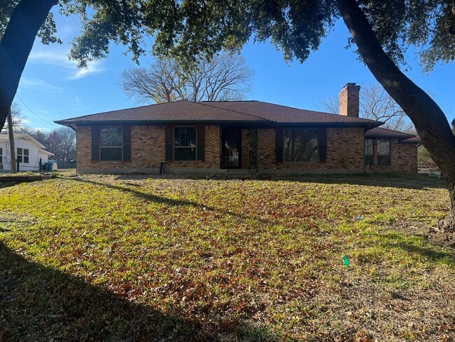
Property Record
1203 N Goliad St, Rockwall, TX 75087


Property Detail
1203 N Goliad St
16757
BARRETT HEIGHTS BLK A LOT 1
Commercialnec
Rockwall
SF2
Texas
A Areas with a 1% annual chance of flooding and a 26% chance of flooding over the life of a 30-year mortgage.
1
2024
Rockwall
2025
Dallas/Ft Worth
040101
Dallas-Fort Worth-Arlington, TX
1,874 SF
NEARBY LISTINGS FOR SALE OR LEASE
DEMOGRAPHICS near 1203 N Goliad St
1 mile
3 mile
5 mile
2025 Total Population
11,750
38,662
123,262
2030 Population
13,953
46,212
143,315
Pop Growth 2025-2030
+ 18.75%
+ 19.53%
+ 16.27%
Average Age
38
39
38
2025 Total Households
3,806
13,767
41,564
HH Growth 2025-2030
+ 18.58%
+ 19.42%
+ 16.40%
Median Household Inc
$125,464
$108,696
$113,332
Avg Household Size
3.00
2.70
2.90
2025 Avg HH Vehicles
2.00
2.00
2.00
Median Home Value
$427,471
$436,737
$399,769
Median Year Built
2007
2006
2005
Nearby Places
Map Layers
Map Styles
 Street
 Aerial
Layers
 Traffic
 Biking
Places
Listings with unknown addresses are not visible on the map
- Restaurants
- Banks
- Shops
- Fitness
- Groceries
PUBLIC TRANSPORTATION
AIRPORT
Dallas Love Field
Drive
Walk
Distance
Dallas Love Field
45 min
29.5 mi
Dallas-Fort Worth International
Drive
Walk
Distance
Dallas-Fort Worth International
57 min
47.0 mi
SALE & LEASE HISTORY
LISTING DATE
SALE/LEASE

Nov 08, 2023
For Lease
Nearby Properties
Address
Land Use
TOTAL SIZE
Lot Size
Zoning
Address
Land Use
TOTAL SIZE
Lot Size
Zoning
193,393 SF
69.53 AC
Address
Land Use
TOTAL SIZE
Lot Size
Zoning
44,191 SF
32.66 AC
Address
Land Use
TOTAL SIZE
Lot Size
Zoning
288,677 SF
41.65 AC
P11
Address
Land Use
TOTAL SIZE
Lot Size
Zoning
413,908 SF
35.30 AC
Address
Land Use
TOTAL SIZE
Lot Size
Zoning
157,834 SF
30.89 AC
Address
Land Use
TOTAL SIZE
Lot Size
Zoning
198,270 SF
21.48 AC
Address
Land Use
TOTAL SIZE
Lot Size
Zoning
250,627 SF
18.17 AC
Address
Land Use
TOTAL SIZE
Lot Size
Zoning
242,845 SF
16.01 AC
Address
Land Use
TOTAL SIZE
Lot Size
Zoning
126,341 SF
18.41 AC
L1
Address
Land Use
TOTAL SIZE
Lot Size
Zoning
211,790 SF
11.58 AC
MF1
Address
Land Use
TOTAL SIZE
Lot Size
Zoning
245,501 SF
6.65 AC
Address
Land Use
TOTAL SIZE
Lot Size
Zoning
353,525 SF
42.99 AC
Address
Land Use
TOTAL SIZE
Lot Size
Zoning
174,826 SF
11.13 AC
Address
Land Use
TOTAL SIZE
Lot Size
Zoning
191,568 SF
10.31 AC
Address
Land Use
TOTAL SIZE
Lot Size
Zoning
223,664 SF
3.80 AC
Address
Land Use
TOTAL SIZE
Lot Size
Zoning
101,024 SF
8.46 AC
Address
Land Use
TOTAL SIZE
Lot Size
Zoning
253,274 SF
18.76 AC
Address
Land Use
TOTAL SIZE
Lot Size
Zoning
121,766 SF
4.28 AC
Address
Land Use
TOTAL SIZE
Lot Size
Zoning
91,612 SF
12 AC
Address
Land Use
TOTAL SIZE
Lot Size
Zoning
152,094 SF
20.29 AC
Address
Land Use
TOTAL SIZE
Lot Size
Zoning
146,730 SF
7.33 AC
Address
Land Use
TOTAL SIZE
Lot Size
Zoning
211,211 SF
10.19 AC
L1
Address
Land Use
TOTAL SIZE
Lot Size
Zoning
139,917 SF
8.91 AC
Address
Land Use
TOTAL SIZE
Lot Size
Zoning
213,280 SF
15.31 AC
Address
Land Use
TOTAL SIZE
Lot Size
Zoning
80,042 SF
6.42 AC
Address
Land Use
TOTAL SIZE
Lot Size
Zoning
42,023 SF
4.19 AC
Address
Land Use
TOTAL SIZE
Lot Size
Zoning
120,525 SF
6.64 AC
Address
Land Use
TOTAL SIZE
Lot Size
Zoning
93,932 SF
11 AC
Address
Land Use
TOTAL SIZE
Lot Size
Zoning
202,607 SF
25.93 AC
Address
Land Use
TOTAL SIZE
Lot Size
Zoning
56,652 SF
11.26 AC
The World's #1 Commercial Real Estate Marketplace
Connect with us
© 2026 CoStar Group
The information above has been obtained from sources believed reliable. While we do not doubt its accuracy we have not verified it and make no guarantee, warranty or representation about it. It is your responsibility to independently confirm its accuracy and completeness. Any projections, opinions, assumptions, or estimates used are for example only and do not represent the current or future performance of the property. The value of this transaction to you depends on tax and other factors which should be evaluated by your tax, financial, and legal advisors. You and your advisors should conduct a careful, independent investigation of the property to determine to your satisfaction the suitability of the property for your needs.