Property Record
12032 Malone Rd, Newark, TX 76071
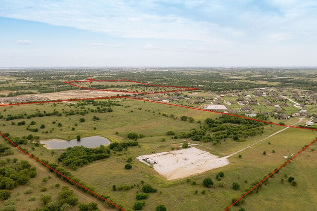
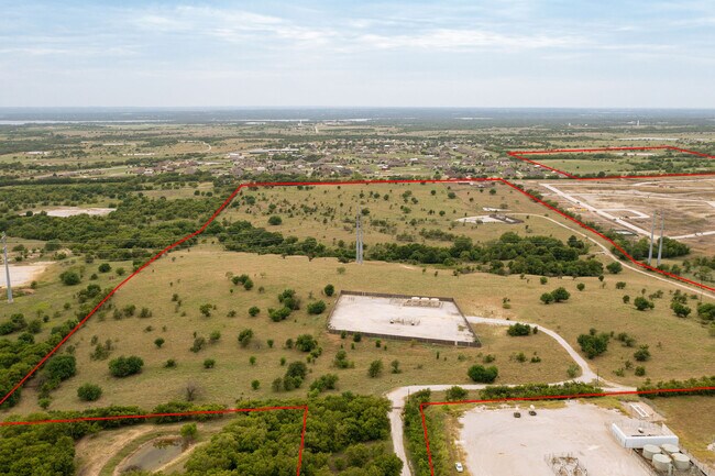

Property Detail
12032 Malone Rd
Dallas-Fort Worth-Arlington, TX
NEWARK ADDN BLOCK B LOT 21
40902811
TARRANT
Residentialacreage
Texas
B and X Area of moderate flood hazard, usually the area between the limits of the 100-year and 500-year floods.
21
2024
1.09 AC
2025
Northwest Ft Worth
114105
Dallas/Ft Worth
NEARBY LISTINGS FOR SALE OR LEASE
DEMOGRAPHICS near 12032 Malone Rd
1 mile
3 mile
5 mile
2024 Total Population
1,948
9,575
35,749
2029 Population
2,214
10,521
39,951
Pop Growth 2024-2029
+ 13.66%
+ 9.88%
+ 11.75%
Average Age
37
37
36
2024 Total Households
650
3,040
11,472
HH Growth 2024-2029
+ 13.69%
+ 10.00%
+ 11.79%
Median Household Inc
$91,980
$121,525
$115,922
Avg Household Size
3.00
3.10
3.10
2024 Avg HH Vehicles
2.00
2.00
2.00
Median Home Value
$312,931
$402,339
$348,440
Median Year Built
2005
2007
2007
Nearby Places
Map Layers
Map Styles
 Street
 Aerial
Transit
 Traffic
 Biking
Places
Listings with unknown addresses are not visible on the map
- Restaurants
- Banks
- Shops
- Fitness
- Groceries
PUBLIC TRANSPORTATION
AIRPORT
Dallas-Fort Worth International
Drive
Walk
Distance
Dallas-Fort Worth International
43 min
30.2 mi
Freight Ports
Port of Shreveport
Drive
Walk
Distance
Port of Shreveport
265 min
242.7 mi
SALE & LEASE HISTORY
LISTING DATE
SALE/LEASE

Aug 04, 2021
For Sale
Nearby Properties
Address
Land Use
TOTAL SIZE
Lot Size
Zoning
Address
Land Use
TOTAL SIZE
Lot Size
Zoning
74,825 SF
13.41 AC
Address
Land Use
TOTAL SIZE
Lot Size
Zoning
247,070 SF
5.79 AC
Address
Land Use
TOTAL SIZE
Lot Size
Zoning
260,000 SF
116.99 AC
Address
Land Use
TOTAL SIZE
Lot Size
Zoning
181,074 SF
14 AC
Address
Land Use
TOTAL SIZE
Lot Size
Zoning
78,591 SF
9.20 AC
Address
Land Use
TOTAL SIZE
Lot Size
Zoning
147,806 SF
21.60 AC
Address
Land Use
TOTAL SIZE
Lot Size
Zoning
111,532 SF
6.75 AC
Address
Land Use
TOTAL SIZE
Lot Size
Zoning
8,707 SF
6.23 AC
Address
Land Use
TOTAL SIZE
Lot Size
Zoning
30,788 SF
3.29 AC
Address
Land Use
TOTAL SIZE
Lot Size
Zoning
39.90 AC
Address
Land Use
TOTAL SIZE
Lot Size
Zoning
97,904 SF
5.06 AC
Address
Land Use
TOTAL SIZE
Lot Size
Zoning
19,985 SF
2.52 AC
Address
Land Use
TOTAL SIZE
Lot Size
Zoning
14,940 SF
10 AC
Address
Land Use
TOTAL SIZE
Lot Size
Zoning
4,350 SF
5 AC
Address
Land Use
TOTAL SIZE
Lot Size
Zoning
39,800 SF
9.25 AC
Address
Land Use
TOTAL SIZE
Lot Size
Zoning
238.17 AC
Address
Land Use
TOTAL SIZE
Lot Size
Zoning
102,700 SF
7.93 AC
Address
Land Use
TOTAL SIZE
Lot Size
Zoning
31,250 SF
3.72 AC
Address
Land Use
TOTAL SIZE
Lot Size
Zoning
24,762 SF
5 AC
Address
Land Use
TOTAL SIZE
Lot Size
Zoning
306.74 AC
Address
Land Use
TOTAL SIZE
Lot Size
Zoning
4,410 SF
1.34 AC
Address
Land Use
TOTAL SIZE
Lot Size
Zoning
Address
Land Use
TOTAL SIZE
Lot Size
Zoning
265.50 AC
Address
Land Use
TOTAL SIZE
Lot Size
Zoning
4,158 SF
1.21 AC
Address
Land Use
TOTAL SIZE
Lot Size
Zoning
57,575 SF
3 AC
Address
Land Use
TOTAL SIZE
Lot Size
Zoning
22.21 AC
Address
Land Use
TOTAL SIZE
Lot Size
Zoning
5,000 SF
3 AC
Address
Land Use
TOTAL SIZE
Lot Size
Zoning
Address
Land Use
TOTAL SIZE
Lot Size
Zoning
14,640 SF
16.26 AC
Address
Land Use
TOTAL SIZE
Lot Size
Zoning
241.27 AC
The World's #1 Commercial Real Estate Marketplace
Connect with us
© 2026 CoStar Group
The information above has been obtained from sources believed reliable. While we do not doubt its accuracy we have not verified it and make no guarantee, warranty or representation about it. It is your responsibility to independently confirm its accuracy and completeness. Any projections, opinions, assumptions, or estimates used are for example only and do not represent the current or future performance of the property. The value of this transaction to you depends on tax and other factors which should be evaluated by your tax, financial, and legal advisors. You and your advisors should conduct a careful, independent investigation of the property to determine to your satisfaction the suitability of the property for your needs.