Property Record
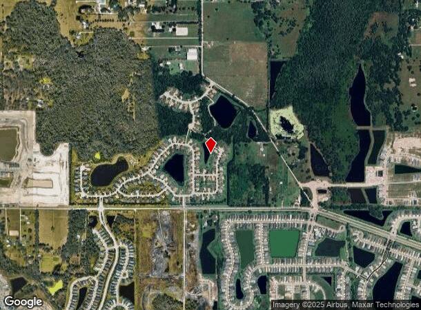
5865 Bella Rd, Parrish, FL 34219
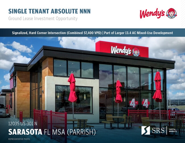
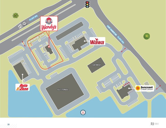
This Property Is For Sale
NEARBY LISTINGS FOR SALE OR LEASE
Property Detail
5865 Bella Rd
North Port-Bradenton-Sarasota, FL
A PARCEL OF LAND LYING IN SEC 32, TWN 33S, RNG 19E, MANATEE COUNTY, FL BEING MORE PARTICULARLY DESC AS FOLLOWS: COM AT THE SE COR OF THE NW 1/4 OF SEC 32, TWN 33S, RNG 19E,
4834-1025-9
Manatee
Residentialnec
Florida
2023
13.36 AC
2024
Manatee
001913
Tampa/St Petersburg
DEMOGRAPHICS near 5865 Bella Rd
1 mile
3 mile
5 mile
2024 Total Population
4,633
31,136
70,866
2029 Population
5,172
35,903
81,379
Pop Growth 2024-2029
+ 11.63%
+ 15.31%
+ 14.84%
Average Age
42
43
46
2024 Total Households
1,669
11,310
27,380
HH Growth 2024-2029
+ 11.68%
+ 14.84%
+ 14.48%
Median Household Inc
$100,340
$110,188
$104,705
Avg Household Size
2.70
2.70
2.50
2024 Avg HH Vehicles
2.00
2.00
2.00
Median Home Value
$413,960
$448,671
$452,285
Median Year Built
2010
2010
2009
Nearby Places
Map Layers
Map Styles
 Street
 Aerial
Transit
 Traffic
 Biking
Places
Listings with unknown addresses are not visible on the map
- Restaurants
- Banks
- Shops
- Fitness
- Groceries
PUBLIC TRANSPORTATION
AIRPORT
Sarasota/Bradenton International
Drive
Walk
Distance
Sarasota/Bradenton International
40 min
21.2 mi
St Pete-Clearwater International
Drive
Walk
Distance
St Pete-Clearwater International
64 min
43.1 mi
Tampa International
Drive
Walk
Distance
Tampa International
69 min
45.7 mi
Freight Ports
Port Manatee
Drive
Walk
Distance
Port Manatee
26 min
14.2 mi
Nearby Properties
Address
Land Use
TOTAL SIZE
Lot Size
Zoning
Address
Land Use
TOTAL SIZE
Lot Size
Zoning
16,661 SF
132.10 AC
RSMH-6
Address
Land Use
TOTAL SIZE
Lot Size
Zoning
96.46 AC
Address
Land Use
TOTAL SIZE
Lot Size
Zoning
164,551 SF
31.22 AC
PD-MU
Address
Land Use
TOTAL SIZE
Lot Size
Zoning
47.43 AC
Address
Land Use
TOTAL SIZE
Lot Size
Zoning
136.89 AC
Address
Land Use
TOTAL SIZE
Lot Size
Zoning
50.25 AC
Address
Land Use
TOTAL SIZE
Lot Size
Zoning
357.30 AC
Address
Land Use
TOTAL SIZE
Lot Size
Zoning
19,260 SF
140.65 AC
A GENERAL
Address
Land Use
TOTAL SIZE
Lot Size
Zoning
66,063 SF
9.24 AC
PD-C
Address
Land Use
TOTAL SIZE
Lot Size
Zoning
166.55 AC
A GENERAL
Address
Land Use
TOTAL SIZE
Lot Size
Zoning
43,464 SF
14.47 AC
VIL VILLAG
Address
Land Use
TOTAL SIZE
Lot Size
Zoning
190.90 AC
PD-R
Address
Land Use
TOTAL SIZE
Lot Size
Zoning
161,245 SF
12.11 AC
PD-MU
Address
Land Use
TOTAL SIZE
Lot Size
Zoning
50,580 SF
5.97 AC
Address
Land Use
TOTAL SIZE
Lot Size
Zoning
53,851 SF
6.32 AC
Address
Land Use
TOTAL SIZE
Lot Size
Zoning
30,101 SF
13.44 AC
PD-C
Address
Land Use
TOTAL SIZE
Lot Size
Zoning
76.98 AC
Address
Land Use
TOTAL SIZE
Lot Size
Zoning
36,700 SF
17 AC
A-1 SUBURB
Address
Land Use
TOTAL SIZE
Lot Size
Zoning
109.06 AC
Address
Land Use
TOTAL SIZE
Lot Size
Zoning
63,916 SF
1.53 AC
PD-MU
Address
Land Use
TOTAL SIZE
Lot Size
Zoning
3.11 AC
Address
Land Use
TOTAL SIZE
Lot Size
Zoning
4.07 AC
Address
Land Use
TOTAL SIZE
Lot Size
Zoning
53,448 SF
3 AC
PD-C
Address
Land Use
TOTAL SIZE
Lot Size
Zoning
25,842 SF
3.92 AC
Address
Land Use
TOTAL SIZE
Lot Size
Zoning
9,806 SF
4.04 AC
VIL VILLAG
Address
Land Use
TOTAL SIZE
Lot Size
Zoning
14,910 SF
4.67 AC
Address
Land Use
TOTAL SIZE
Lot Size
Zoning
17,677 SF
9.52 AC
A-1 SUBURB
Address
Land Use
TOTAL SIZE
Lot Size
Zoning
3,749 SF
22.25 AC
A GENERAL
Address
Land Use
TOTAL SIZE
Lot Size
Zoning
113.80 AC
The World's #1 Commercial Real Estate Marketplace
Connect with us
© 2026 CoStar Group
The information above has been obtained from sources believed reliable. While we do not doubt its accuracy we have not verified it and make no guarantee, warranty or representation about it. It is your responsibility to independently confirm its accuracy and completeness. Any projections, opinions, assumptions, or estimates used are for example only and do not represent the current or future performance of the property. The value of this transaction to you depends on tax and other factors which should be evaluated by your tax, financial, and legal advisors. You and your advisors should conduct a careful, independent investigation of the property to determine to your satisfaction the suitability of the property for your needs.