Property Record
1204 Bundrant Dr, Killeen, TX 76543
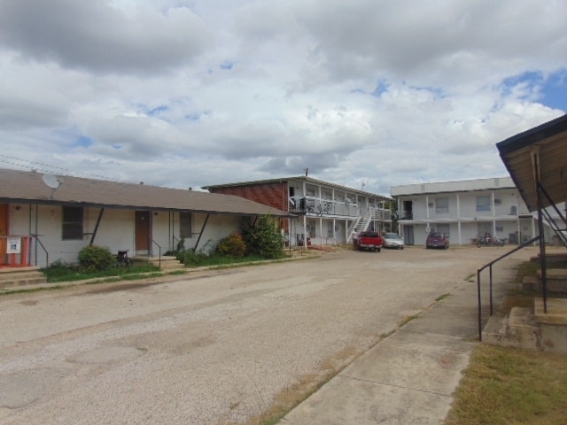

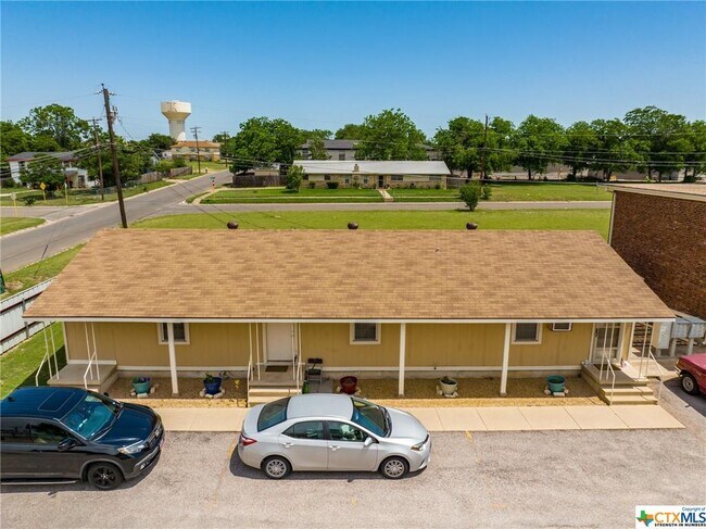
Property Detail
1204 Bundrant Dr
97661
A0266BC A DICKSON, 710-281 & BUSINESS PERSONAL PROPERTY, ACRES .79
Multifamilydwelling
Bell
R-3
Texas
B and X Area of moderate flood hazard, usually the area between the limits of the 100-year and 500-year floods.
0.79 AC
2025
Killeen/Fort Hood
2025
Killeen/Temple/Fort Hood
022101
Killeen-Temple, TX
10,880 SF
NEARBY LISTINGS FOR SALE OR LEASE
DEMOGRAPHICS near 1204 Bundrant Dr
1 mile
3 mile
5 mile
2025 Total Population
12,745
64,842
143,367
2030 Population
13,585
69,122
151,552
Pop Growth 2025-2030
+ 6.59%
+ 6.60%
+ 5.71%
Average Age
34
34
34
2025 Total Households
5,305
26,041
54,116
HH Growth 2025-2030
+ 6.86%
+ 6.84%
+ 5.95%
Median Household Inc
$53,795
$47,801
$57,808
Avg Household Size
2.30
2.30
2.50
2025 Avg HH Vehicles
2.00
2.00
2.00
Median Home Value
$136,946
$150,660
$201,607
Median Year Built
1980
1981
1988
Nearby Places
Map Layers
Map Styles
 Street
 Aerial
Transit
 Traffic
 Biking
Places
Listings with unknown addresses are not visible on the map
- Restaurants
- Banks
- Shops
- Fitness
- Groceries
PUBLIC TRANSPORTATION
AIRPORT
Killeen Municipal
Drive
Walk
Distance
Killeen Municipal
10 min
3.9 mi
Robert Gray AAF
Drive
Walk
Distance
Robert Gray AAF
26 min
13.5 mi
SALE & LEASE HISTORY
LISTING DATE
SALE/LEASE

May 21, 2022
For Sale
Jun 10, 2020
For Sale
Aug 20, 2024
For Sale
Apr 06, 2024
For Sale
Nearby Properties
Address
Land Use
TOTAL SIZE
Lot Size
Zoning
Address
Land Use
TOTAL SIZE
Lot Size
Zoning
4 SF
55.08 AC
Address
Land Use
TOTAL SIZE
Lot Size
Zoning
1 SF
7.81 AC
Address
Land Use
TOTAL SIZE
Lot Size
Zoning
Address
Land Use
TOTAL SIZE
Lot Size
Zoning
200,345 SF
42.44 AC
CUP
Address
Land Use
TOTAL SIZE
Lot Size
Zoning
133,210 SF
8.52 AC
R-3
Address
Land Use
TOTAL SIZE
Lot Size
Zoning
160,143 SF
13.30 AC
Address
Land Use
TOTAL SIZE
Lot Size
Zoning
151,969 SF
10 AC
R-3
Address
Land Use
TOTAL SIZE
Lot Size
Zoning
13,000 SF
31.72 AC
Address
Land Use
TOTAL SIZE
Lot Size
Zoning
46,892 SF
2.48 AC
Address
Land Use
TOTAL SIZE
Lot Size
Zoning
154,910 SF
9.38 AC
Address
Land Use
TOTAL SIZE
Lot Size
Zoning
192,820 SF
14.26 AC
Address
Land Use
TOTAL SIZE
Lot Size
Zoning
386,344 SF
171.40 AC
B-5
Address
Land Use
TOTAL SIZE
Lot Size
Zoning
132,202 SF
11.52 AC
R-3
Address
Land Use
TOTAL SIZE
Lot Size
Zoning
133,648 SF
6.52 AC
Address
Land Use
TOTAL SIZE
Lot Size
Zoning
108,964 SF
4.50 AC
Address
Land Use
TOTAL SIZE
Lot Size
Zoning
114,585 SF
4.64 AC
Address
Land Use
TOTAL SIZE
Lot Size
Zoning
121,285 SF
11.75 AC
Address
Land Use
TOTAL SIZE
Lot Size
Zoning
162,090 SF
8.28 AC
R-3
Address
Land Use
TOTAL SIZE
Lot Size
Zoning
366,112 SF
44.17 AC
Address
Land Use
TOTAL SIZE
Lot Size
Zoning
201,823 SF
20.78 AC
Address
Land Use
TOTAL SIZE
Lot Size
Zoning
228,165 SF
22.43 AC
Address
Land Use
TOTAL SIZE
Lot Size
Zoning
120,948 SF
32.68 AC
Address
Land Use
TOTAL SIZE
Lot Size
Zoning
152,393 SF
9.78 AC
Address
Land Use
TOTAL SIZE
Lot Size
Zoning
91,475 SF
11.33 AC
Address
Land Use
TOTAL SIZE
Lot Size
Zoning
176,443 SF
10 AC
R-3
Address
Land Use
TOTAL SIZE
Lot Size
Zoning
126,152 SF
8 AC
B-5
Address
Land Use
TOTAL SIZE
Lot Size
Zoning
57,219 SF
10.35 AC
Address
Land Use
TOTAL SIZE
Lot Size
Zoning
117,988 SF
7.77 AC
Address
Land Use
TOTAL SIZE
Lot Size
Zoning
1 SF
13.02 AC
Address
Land Use
TOTAL SIZE
Lot Size
Zoning
79,142 SF
2.11 AC
The World's #1 Commercial Real Estate Marketplace
Connect with us
© 2026 CoStar Group
The information above has been obtained from sources believed reliable. While we do not doubt its accuracy we have not verified it and make no guarantee, warranty or representation about it. It is your responsibility to independently confirm its accuracy and completeness. Any projections, opinions, assumptions, or estimates used are for example only and do not represent the current or future performance of the property. The value of this transaction to you depends on tax and other factors which should be evaluated by your tax, financial, and legal advisors. You and your advisors should conduct a careful, independent investigation of the property to determine to your satisfaction the suitability of the property for your needs.