Property Record
1204 Crocus St, Mays Landing, NJ 08330

NEARBY LISTINGS FOR SALE OR LEASE
Property Detail
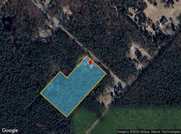
1204 Crocus St
Atlantic City-Hammonton, NJ
Jackson Park
11-00223-0000-00002
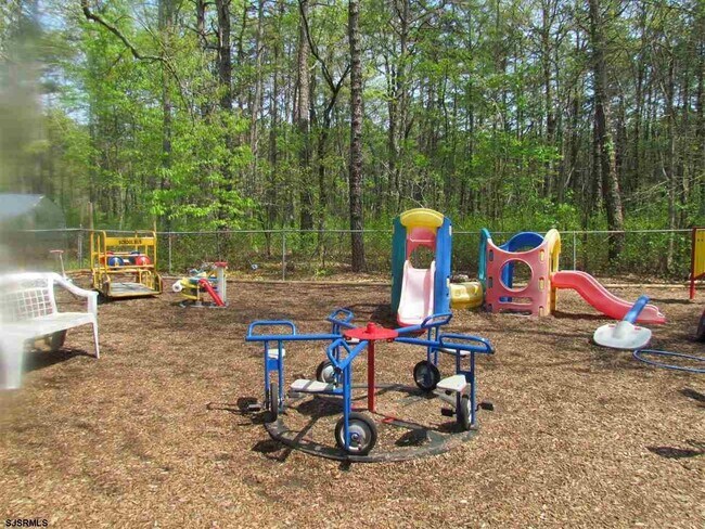
HEADSTART BUILDINGS
Daycare
Atlantic
ARE
New Jersey
34001C0144F
2
2024
4.37 AC
2025
Atlantic City/Hammonton
010401
Philadelphia
1,252 SF
DEMOGRAPHICS near 1204 Crocus St
1 Mile
3 Mile
5 Mile
2024 Total Population
923
8,547
22,271
2029 Population
900
8,346
21,837
Pop Growth 2024-2029
(2.49%)
(2.35%)
(1.95%)
Average Age
44
42
40
2024 Total Households
381
3,294
8,389
HH Growth 2024-2029
(2.89%)
(2.98%)
(2.59%)
Median Household Inc
$88,451
$70,201
$71,980
Avg Household Size
2.40
2.50
2.50
2024 Avg HH Vehicles
2.00
2.00
2.00
Median Home Value
$225,373
$227,869
$235,875
Median Year Built
1964
1967
1982
Nearby Places
Map Layers
Map Styles
 Street
 Aerial
- Restaurants
- Banks
- Shops
- Fitness
- Groceries
PUBLIC TRANSPORTATION
COMMUTER RAIL
Egg Harbor City (Atlantic City Line - NJ Transit Commuter Rail (NJ Transit))
DRIVE
WALK
Distance
Egg Harbor City (Atlantic City Line - NJ Transit Commuter Rail (NJ Transit))
4 min
1.7 mi
AIRPORT
Atlantic City International
DRIVE
WALK
Distance
Atlantic City International
34 min
9.6 mi
Freight Ports
Broadway Terminal - Pier 5
DRIVE
WALK
Distance
Broadway Terminal - Pier 5
54 min
40.8 mi
SALE & LEASE HISTORY
LISTING DATE
SALE/LEASE

Mar 05, 2021
For Sale
Nearby Properties
Address
Land Use
TOTAL SIZE
Lot Size
Zoning
Address
Land Use
TOTAL SIZE
Lot Size
Zoning
66.23 AC
3.2C
Address
Land Use
TOTAL SIZE
Lot Size
Zoning
35.65 AC
IRD
Address
Land Use
TOTAL SIZE
Lot Size
Zoning
68,744 SF
5.03 AC
R-11
Address
Land Use
TOTAL SIZE
Lot Size
Zoning
94,984 SF
2.07 AC
R-9
Address
Land Use
TOTAL SIZE
Lot Size
Zoning
2.27 AC
R-9
Address
Land Use
TOTAL SIZE
Lot Size
Zoning
70.67 AC
RD-5
Address
Land Use
TOTAL SIZE
Lot Size
Zoning
90.90 AC
RD-5
Address
Land Use
TOTAL SIZE
Lot Size
Zoning
21,056 SF
5.23 AC
IND
Address
Land Use
TOTAL SIZE
Lot Size
Zoning
4,652 SF
14.80 AC
HC-2
Address
Land Use
TOTAL SIZE
Lot Size
Zoning
12,673 SF
2.58 AC
R-9
Address
Land Use
TOTAL SIZE
Lot Size
Zoning
14,546 SF
0.48 AC
R-C
Address
Land Use
TOTAL SIZE
Lot Size
Zoning
15,974 SF
2.87 AC
H-C
Address
Land Use
TOTAL SIZE
Lot Size
Zoning
31.90 AC
TI
Address
Land Use
TOTAL SIZE
Lot Size
Zoning
6,256 SF
4.55 AC
R-22
Address
Land Use
TOTAL SIZE
Lot Size
Zoning
31.06 AC
IRD
Address
Land Use
TOTAL SIZE
Lot Size
Zoning
9,984 SF
0.52 AC
R-6
Address
Land Use
TOTAL SIZE
Lot Size
Zoning
23,500 SF
2.27 AC
H-C
Address
Land Use
TOTAL SIZE
Lot Size
Zoning
2.15 AC
H-C
Address
Land Use
TOTAL SIZE
Lot Size
Zoning
9,972 SF
0.69 AC
R-6
Address
Land Use
TOTAL SIZE
Lot Size
Zoning
8,720 SF
2.76 AC
R-9
Address
Land Use
TOTAL SIZE
Lot Size
Zoning
10,674 SF
0.55 AC
R-9
Address
Land Use
TOTAL SIZE
Lot Size
Zoning
8,056 SF
1.12 AC
R-9
Address
Land Use
TOTAL SIZE
Lot Size
Zoning
10,044 SF
0.28 AC
R-6
Address
Land Use
TOTAL SIZE
Lot Size
Zoning
8,550 SF
0.34 AC
R-C
Address
Land Use
TOTAL SIZE
Lot Size
Zoning
17 AC
AG
Address
Land Use
TOTAL SIZE
Lot Size
Zoning
6.36 AC
VC
Address
Land Use
TOTAL SIZE
Lot Size
Zoning
4,935 SF
1.38 AC
R-9
Address
Land Use
TOTAL SIZE
Lot Size
Zoning
1,000,000 SF
4 AC
HC-2
Address
Land Use
TOTAL SIZE
Lot Size
Zoning
47,696 SF
4.87 AC
IND
Address
Land Use
TOTAL SIZE
Lot Size
Zoning
12,566 SF
0.96 AC
H-C
The World's #1 Commercial Real Estate Marketplace
Connect with us
© 2025 CoStar Group
The information above has been obtained from sources believed reliable. While we do not doubt its accuracy we have not verified it and make no guarantee, warranty or representation about it. It is your responsibility to independently confirm its accuracy and completeness. Any projections, opinions, assumptions, or estimates used are for example only and do not represent the current or future performance of the property. The value of this transaction to you depends on tax and other factors which should be evaluated by your tax, financial, and legal advisors. You and your advisors should conduct a careful, independent investigation of the property to determine to your satisfaction the suitability of the property for your needs.